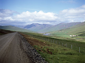
Blanda
| Blanda | ||
|
Blanda in Blöndudalur |
||
| Data | ||
| location | Iceland | |
| River system | Blanda | |
| muzzle |
Húnafjörður ( Arctic Ocean ) Coordinates: 65 ° 39 ′ 40 " N , 20 ° 18 ′ 0" W 65 ° 39 ′ 40 " N , 20 ° 18 ′ 0" W |
|
| Mouth height |
0 m
|
|
| length | 125 km | |
| Catchment area | 2370 km² | |
| Drain |
NNQ MQ HHQ |
20 m³ / s 60 m³ / s 550 m³ / s |
| Reservoirs flowed through | Blondulón | |
| Communities | Blönduós | |
|
Blanda at the mouth with Blönduós |
||
The Blanda is a glacial river in northern Iceland .
Most important dates
Blanda has a length of over 125 km, making it one of the longest rivers in Iceland. The average amount of water in the river is 60 m³ / s. In summer the amount of water is 40–90 m³ / sec., In winter 20–30 m³ / sec. The largest measured amount of water in the Blöndudalur was 550 m³ / sec.
course
The river has its source in many small streams on the Hofsjökull ice cap on the Icelandic highlands . To the north of this is the Blöndujökull glacier tongue .
It crosses the Blöndulón reservoir . Finally it re-enters the built-up area in the district of Húnavatnssýsla , flows through a gorge, Blöndugil , and flows into the bay of Húnaflói , more precisely into the Húnafjörður , at the place named after him, Blönduós ( isl. " Mouth of the Blanda ") of the Arctic Ocean .
Power plant and reservoir
The Blanda is dammed up in the highlands in the Blöndulón, with the water being used to generate electricity in the Blanda power station, which has been in existence since 1991 and is located a few kilometers downstream .
traffic
There are numerous well-known fords in the river, which are now used mainly to catch sheep in autumn.
The northern part of the Kjölur highland slope follows the river over long stretches. The Hringvegur crosses it on a bridge near Blönduós .
Salmon fishing
Blanda is considered to be one of the best salmon rivers in the country. The demand is correspondingly high. In 2010, 2,777 salmon were caught in the river, according to the Association of Fishing Rights Holders.
Protected island in the river: Hrútey
Shortly before Blönduós is the small island of Hrútey - d. i. the island of Aries - which has been a nature reserve since 1975. The 11 hectare island is mainly covered with birch trees and is the nesting place for numerous bird species. Many different species of geese can be found here in summer. From the end of April to the end of June, access is closed due to the breeding season.
Efforts have been made to reforest the island since 1943 ; it is under the aegis of the Skógræktarfélag Austur-Húnvetningar and was made accessible to the public in 2004 under the seal of Opinn skógur ( Open Forest ) with the help of a footbridge over the Blanda.
See also
Web links
- Skógræktarfélag Íslands (Icelandic Forest and Forest Association) (English)
- Visit Iceland: Hrútey (English)
- The Blanda power plant
Individual evidence
- ↑ a b c d e f Íslandshandbókin. Náttúra, saga og sérkenni. 1. bindi. Edited by T. Einarsson, H. Magnússon. Örn og Örlygur, Reykjavík 1989, p. 342
- ↑ a b cf. Ísland Vega Atlas. Ed. Ferðakort, Reykjavík 2006, 14 and 15
- ↑ Landsvirkjun: Blanda Hydropower Station . Retrieved August 18, 2019 .
- ↑ http://angling.is/en/waters/salmon-rivers/on-the-northwest-coast/6456/ (English); Accessed July 30, 2011
- ^ HU Schmid: Dictionary Icelandic - German. Buske, Hamburg, 2001, 112 and 54, respectively
- ↑ Vegahandbókin. Ed. Landmælingar Íslands, 2006, 508
- ↑ See also: Skógræktarfélag Íslands: Hrútey ; accessed: September 8, 2012

