
Húnafjörður
| Húnafjörður | ||
|---|---|---|
 Húnafjörður |
||
| Waters | Greenland Sea | |
| Land mass | Iceland | |
| Geographical location | 65 ° 36 ′ N , 20 ° 28 ′ W | |
|
||
| width | 15 km | |
| depth | 10 km | |
| Tributaries | Hóp , Húnavatn, Blanda | |

The Húnafjörður is a fjord in northern Iceland . It is the eastern part of the Húnaflói Bay and is bounded by the Vatnsnes peninsulas to the west and Skagi to the east.
Blönduós is on the east bank and Skagaströnd is a little further north . The region belongs to the municipality of Húnavatn .
With a width of around 15 kilometers and a depth of around 10 kilometers, the bay is more of a wide bay, but is still referred to as a fjord ( Fjörður ) in Icelandic usage .
To the south of the bay are some lagoon lakes , including the Hóp , separated from the fjord by the Þingeyrasandur headland , on which the Þingeyrarkirkja church stands. The Bjargarós river flows into the Hóp . The lagoons to the east are fed by the Vatnsdalsá river , which drains the Vatnsdalur valley. The river flows into the Húnavatn .
The glacier river Blanda flows directly into the bay at Blönduós .
The rock Hvítserkur on the west side of the fjord is known, according to legend, a petrified troll .

Location of Húnafjörður
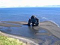
Hvítserkur

