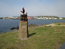
Skagastrond

|
|
| Basic data | |
|---|---|
| State : |
|
| Region: | Norðurland vestra |
| Constituency : | Norðvesturkjördæmi |
| Population: | 452 (January 1, 2019) |
| Surface: | 53 km² |
| Population density: | 8.53 inhabitants / km² |
| Post Code: | 545 |
| politics | |
| Community number | 5609 |
| Mayor: | Magnús B. Jónsson |
| Contact | |
| Website: | www.skagastrond.is |
| map | |

Coordinates: 65 ° 49 ′ N , 20 ° 18 ′ W |
|
Skagaströnd [ ˈskaːɣastrœnt ] ( Isl. Sveitarfélagið Skagaströnd ) is an Icelandic municipality in the region of Norðurland vestra . On January 1, 2019, the community had 452 inhabitants.
geography
Skagaströnd is located on the Skagi peninsula and at the same time on the east bank of the Húnaflói Bay in northern Iceland. To the north and south lies the municipality of Skagabyggð , to the east that of Skagafjörður .
The main town of the municipality of the same name, an important fishing town, is located in a bay below the mountain Spákonufell and the basalt rock formation called Spákonufellshöfði (German for "fortune tellers foothills "). Therefore it was called Höfðakaupstaður in earlier times .
Surname
The name (dt. Skagi beach or more precisely peninsula beach ) initially referred to the coastal strip on the Húnaflói bay from the Laxá á Refasveit river to the tip of the Skagi peninsula. In the past there were numerous winter fishing villages here (isl. Verstöðvar ).
The name of the mountain Spákonufell and, to a certain extent, the old name of the place come from a folk tale, according to which the fortune teller Þórdís would have settled in the Spákonufell farm below the mountain of the same name in the 10th century. Both were named after her. It is also used in the Icelandic sagas , e.g. B. Mentioned in the Vatsndæla saga, where she got caught up in wizarding battles with Guðmundur ríki from Möðruvellir . In Jón Árnason's collection of folk sagas, too, there are a number of legends about her, e. B. Regarding a treasure hidden in the mountains.
history
The English and Hanseatic merchants probably already traded here in the 15th and 16th centuries. However, they were expelled after the establishment of the Danish trade monopoly in 1602. At that time the royal order was issued that the people from Húnavatnssýsla as well as from western Skagafjörður were only allowed to do business with the Danish merchants in Skagaströnd. At first this only happened in summer, only from the beginning of the 18th century are permanent buildings occupied and from then on the Danish merchants also lived on site.
The place slowly flourished like all of Iceland in the 19th century. First under the merchant Christian G. Schram, later under the merchants Bergmann and Hildebrandt, although competition arose at the end of the 19th century. This intensified when businesses were set up in Blönduós and Sauðárkrókur .
At the beginning of the 20th century, people in Skagaströnd got into fishing and fish processing to an increasing extent, which have since been the main livelihoods in the town. Already in the years of the First World War , but also in the 1920s and 1930s, the fishing grounds in the Húnaflói were considered so excellent that up to 80 ships could be seen fishing at the same time. The city's port was expanded from the 1920s onwards, and even further after the Second World War . In 1944 and 1946 a cold store and a herring factory were built. But the herrings were largely absent after the 1960s. Despite the further boom in the 1970s, it has not yet succeeded in attracting larger employers other than fishing and processing. In the meantime, however, there is also tourism, e.g. B. with the Wild West inn Kántrýbær .
population
The population has largely stagnated in recent years.
- 2005: 547 inhabitants
- 2009: 521 inhabitants
- 2011: 530 inhabitants
Web links
Individual evidence
- ^ HU Schmid: Dictionary Icelandic - German. Buske, Hamburg, 234, 131, 116.
- ^ Jón Torfason: Húnaþing eystra frá jöklum til ystu stranda. Ferðafélag Íslands, árbók 2007. Reykjavík 2007, 182 f.
- ^ HU Schmid: Dictionary Icelandic - German. Buske, Hamburg, 215 u. 243
- ↑ cf. Íslandshandbókin. Náttúra, saga og sérkenni. 1. bindi. Edited by T. Einarsson, H. Magnússon. Örn og Örlygur, Reykjavík 1989, 357.
- ^ Jón Torfason: Húnaþing eystra frá jöklum til ystu stranda. Ferðafélag Íslands, árbók 2007. Reykjavík 2007, 185
- ↑ a b c d Jón Torfason: Húnaþing eystra frá jöklum til ystu stranda. Ferðafélag Íslands, árbók 2007. Reykjavík 2007, 187
- ↑ cf. http://northwest.is/2skagastrond.asp .
- ↑ http://hagstofa.is/?PageID=2593&src=/temp/Dialog/varval.asp?ma=MAN03106%26ti=Mannfj%F6ldi+eftir+bygg%F0akj%F6rnum%2C+kyni+og+aldri+1 % 2E + jan% FAar + 1998% 2D2011 +++++% 26path = .. / Database / mannfjoldi / Byggdakjarnar /% 26lang = 3% 26units = Fj% F6ldi Hagstofa (Statistical Office of Iceland) (Icelandic); Accessed July 31, 2011.

