Húnaþing vestra

|
|
| Basic data | |
|---|---|
| State : |
|
| Region: | Norðurland vestra |
| Constituency : | Norðvesturkjördæmi |
| Sýsla : | Vestur-Húnavatnssýsla |
| Population: | 1181 (January 1, 2019) |
| Surface: | 2506 km² |
| Population density: | 0.47 inhabitants / km² |
| Post Code: | 530 Hvammstangi (place), 531 Hvammstangi (area) |
| politics | |
| Community number | 5508 |
| Mayor: | Skúli Þórðarson |
| Contact | |
| Address of the municipal administration: | Klapparstíg 4 530 Hvammstanga |
| Website: | www.hunathing.is |
| map | |

Coordinates: 65 ° 24 ′ N , 20 ° 57 ′ W |
|
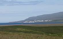
The municipality of Húnaþing vestra is located in northwest Iceland on the Húnaflói Bay in the Norðurland vestra region .
On January 1, 2019, the community had 1,181 inhabitants. 573 inhabitants lived in the main town of Hvammstangi . The second largest settlement is Laugarbakki with 55 inhabitants.
geography
The municipality lies north on the Húnaflói ; in the north-west is the Hrútafjörður , east of it the Miðfjörður , even further east of the Húnafjörður . The north of the municipality is formed by the Vatnsnes peninsula , the Hindisvík bay is at its northern tip. In the northeast of the municipality are the lakes Vesturhópsvatn and Sigríðarstaðavatn , which are located west of the large lake Hóp . Its eastern bank is already in the rural municipality of Húnavatn .
In the southeast of the municipality is the lake-rich plateau Arnarvatnsheiði and the lake Arnarvatn stóra, which gives it its name .
To the northwest of the municipality of Húnaþing vestra is the municipality of Strandabyggð , east of Húnavatn , south of Borgarbyggð , and west of Dalabyggð .
history
The area had risen economically due to rich shrimp fishing grounds in the Húnaflói. The problem of rural exodus has existed for years (see population development).
The municipality was formed in 1998 by the merger of seven rural communities: Staðarhreppur, Fremri-Torfustaðahreppur, Ytri-Torfustaðahreppur, Hvammstangahreppur, Kirkjuhvammshreppur, Þverárhreppur and Þorkelshólshreppur. On January 1, 2012, the western rural community of Bær was incorporated.
Population development
As in now only a few areas of Iceland apart from the southwest around the capital Reykjavík, the population development in Húnaþing vestra is minimally declining (1997 to 2006: −11.4%).
| date | Residents |
|---|---|
| Dec 1, 1997 | 1.317 |
| Dec. 1, 2003 | 1,175 |
| Dec. 1, 2004 | 1,175 |
| Dec 1, 2005 | 1,173 |
| Dec 1, 2006 | 1,167 |
traffic
The ring road ( Hringvegur ) runs south of Hvammstangi .
Daughters and sons of the church
- Björgvin Páll Gústavsson (* 1985), handball player
- Ásgeir Trausti (* 1992), singer-songwriter
Web links
- Local government website (Icelandic)
