Vesturhópsvatn
| Vesturhópsvatn | ||
|---|---|---|

|
||
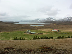
| Vesturhópsvatn with Vatnsendatjörn, looking south-southwest | ||
| Geographical location | Iceland | |
| Tributaries | Reyðarlækur | |
| Drain | Faxalækur | |
| Data | ||
| Coordinates | 65 ° 28 '30 " N , 20 ° 38' 30" W | |
|
|
||
| Altitude above sea level | 19 m | |
| surface | 10.3 km² | |
| length | 7 km | |
| width | 2.3 km | |
| Maximum depth | 28 m | |
The Vesturhópsvatn is a lake in the northwest of Iceland . It is located in the municipality of Húnaþing vestra in the Norðurland vestra region .
geography
The Vesturhópsvatn is located southwest of the Hóp and south of the Sigríðarstaðavatn . The Víðidalsá , with which the lake is connected via the Faxalækur , flows east of the lake . To the east of the lake is the Borgarvirki fortress .
To the west is the Vatnsnesfjall on Vatnsnes , also to the west of the lake is the river Klambraá .
North of Vesturhópsvatn is the small lake Vatnsendatjörn. The area north of the lake is called Vesturhóp .
To the south, Vesturhópsvatn is connected to Lake Miðfjarðarvatn via Reyðarlækur .
The lake is about 7 km long and 2.3 km wide. Its area is about 10.3 km²; the maximum depth is 28 m and the lake is about 19 m above sea level.
traffic
Hringvegur , Iceland's most important road, runs a few kilometers east of the lake . Road 711 runs west of the lake, road 717 runs north and east .
