Skagabyggð
| Basic data | |
|---|---|
| State : |
|
| Region: | Norðurland vestra |
| Constituency : | Norðvesturkjördæmi |
| Sýsla : | Austur-Húnavatnssýsla |
| Population: | 90 (January 1, 2019) |
| Surface: | 489 km² |
| Population density: | 0.18 inhabitants / km² |
| Post Code: | 545 |
| politics | |
| Community number | 5611 |
| Head of the municipal council: | Rafn Sigurbjörnsson |
| Contact | |
| Address of the municipal administration: | Örlygsstöðum 2 545 Skagaströnd |
| map | |

Coordinates: 65 ° 54 ′ N , 20 ° 17 ′ W |
|
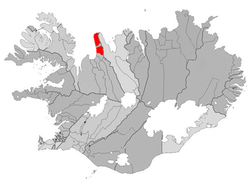
The municipality of Skagabyggð is located in northwest Iceland in the Norðurland vestra region . On January 1, 2019, the community had 90 inhabitants. The church is Höskuldsstaðir .
geography
The community is located on the east bank of the Húnaflói . In the northeast of the municipality is the area of Skagaheiði . The largest lake is the Langavatn north of the Skagastrandarfjöll . The northern and southern parts of the municipality are delimited by the municipality of Skagaströnd in between . South of the municipality is Blönduós , east Skagafjörður .
history
Skagabyggð was formed on December 31, 2001 through the merger of the two rural communities Vindhælishreppur and Skagahreppur.
Population development
| date | Residents |
|---|---|
| Dec. 1, 1997: | 91 (area 2001) |
| Dec. 1, 2003: | 97 |
| Dec. 1, 2004: | 101 |
| Dec. 1, 2005: | 99 |
| Dec. 1, 2006: | 96 |
| Jan. 1, 2009: | 102 |