Landvegur
| Main Street 26 Iceland |
||||||||||||||||||||||||||||
| Landvegur | ||||||||||||||||||||||||||||

|
||||||||||||||||||||||||||||
| map | ||||||||||||||||||||||||||||
| Basic data | ||||||||||||||||||||||||||||
| Operator: | Vegagerðin | |||||||||||||||||||||||||||
| Start of the street: |
Hringvegur ( 63 ° 53 ′ N , 20 ° 30 ′ W ) |
|||||||||||||||||||||||||||
| End of street: |
Þjórsárdalsvegur ( 64 ° 9 ′ N , 19 ° 31 ′ W ) |
|||||||||||||||||||||||||||
| Overall length: | 62.61 km | |||||||||||||||||||||||||||
|
Course of the road
|
||||||||||||||||||||||||||||
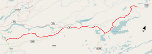
The Landvegur is a main road in the south of Iceland . It connects the ring road with the southern Sprengisandur slope.
The road is number 26 and branches off the ring road between Selfoss and Hella in the east-northeast direction. It is 63 km long and the first 49 km to Landmannaleið are paved. The Landvegur runs south of the Þjórsá and has some side roads to the surrounding farms in the lower section. It ends in the east where it meets the Þjórsárdalsvegur ![]() . The further course bears the number 26, but is then called Sprengisandsleið .
. The further course bears the number 26, but is then called Sprengisandsleið .
Web links
- Webcam on the ring road towards Landvegur
See also
Individual evidence
- ↑ Vegaskrá 2016 - kaflaskipt. Retrieved November 3, 2017 (isl.).
