Hella (Rangárþing ytra)
| Hella | ||
|---|---|---|
|
|
||
| Coordinates | 63 ° 50 ′ N , 20 ° 24 ′ W | |
| Basic data | ||
| Country | Iceland | |
| Southurland | ||
| ISO 3166-2 | IS-8 | |
| local community | Rangárþing ytra | |
| Residents | 865 (January 1, 2019) | |
|
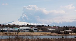
View over Hella with the volcanic eruption of Eyjafjallajökull . 2010
|
||
Hella [ ˈhɛtla ] is a place in southern Iceland in the municipality of Rangárþing ytra . On January 1, 2019, the place had 865 inhabitants.
geography
Hella is located on the Ytri-Rangá river , about 15 km west of Hvolsvöllur and about 25 km east of Selfoss .
Surname
The name means "cave" in German. This is because there are actually a number of caves on the banks of the river in the village.
They are associated with Irish monks, hermits who also live here in these caves - such as B. also to have lived on the island of Papey near Djúpivogur or on the Westman Islands . On the other hand, this tradition could not be proven on the basis of archaeological finds.
Nowadays the caves are often used as storage rooms, one of them, in the south of the Ringstrasse , even serves as a garage.
Service center
Hella was founded as a service center for the farmers in the area and is still today. However, at the beginning of the 21st century, tourism is playing an increasing role.
You can find supermarkets, petrol stations, a hotel and a swimming pool here. There is also a primary school in town.
In the summer of 2004 and 2009, the state competition for Icelandic horses called Landsmót took place on the Gaddstaðaflatir site near Hella .
In July there is an annual festival called Töðugjöld .
earthquake
Since the place is in the south of the country, which is criss-crossed by crevasses, it was sometimes affected by strong earthquakes. One of the two earthquakes in 2000 (magnitude 6.5 on the Richter scale) had its epicenter very close. Some damage was done to streets and houses. The earthquakes of 2008 were also felt, although the epicentres were further west.
traffic
Hella is located on the Hringvegur , the country's most important traffic artery.
Web links
- Hella in nat.is (Icelandic)
- Hella on landsmot.is (Icelandic)


