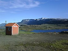
Breiðdalsheiði
The Breiðdalsheiði is a plateau in the east of Iceland .
The part of the Icelandic ring road that runs through it until November 2017 is also named. In this area the road is not yet paved and difficult to drive in winter. It was then avoided over the Norðfjarðarvegur ![]() to Reyðarfjörður and further on the Suðurfjarðavegur . On November 11, 2017, this alternative route was officially rededicated as part of the ring road (number 1), while the original route became Skriðdals- og Breiðdalsvegur
to Reyðarfjörður and further on the Suðurfjarðavegur . On November 11, 2017, this alternative route was officially rededicated as part of the ring road (number 1), while the original route became Skriðdals- og Breiðdalsvegur![]() .
.
The connection from Egilsstaðir to Breiðdalsvík is 82 kilometers long over the Breiðdalsheiði, 25 of which are unpaved. The route over the East Fjords is 10 kilometers longer, but completely paved.
The Breiðdalsheiði lies between the valley Breiðdalur and the associated bay Breiðdalsvík on the one hand and the lake Lagarfljót on the other. You can take this pass road as a connecting route from Höfn í Hornarfirði to Egilsstaðir , if you do not prefer the shorter but much steeper route (17% slope ) over the Öxi pass .
At its highest point, the Breiðdalsheiði reaches 470 m.
A small lake, the Heiðarvatn , is located near the pass road. You can catch trout in it.
As on many such passes in Iceland, there is also an emergency shelter here, which is called Stefánsbúð .
The largest part of the Breiðdalsheiði is located in the area of a huge extinct central volcano, the Breiðdalsvulkan , which was active about 6-7 million years ago.
See also
Web links
- Webcam on the Breiðdalsheiði looking west
- Webcam on the Breiðdalsheiði looking east
Individual evidence
- ^ Geir Finnsson: Changes To Ring Road This Weekend ( English ) In: Iceland Review . November 9, 2017. Retrieved November 11, 2017.
Coordinates: 64 ° 54'25.2 " N , 14 ° 36'21.6" W.
