Varmahlíð (Skagafjörður)
| Varmahlíð | ||
|---|---|---|
|
|
||
| Coordinates | 65 ° 33 ′ N , 19 ° 27 ′ W | |
| Basic data | ||
| Country | Iceland | |
| Norðurland vestra | ||
| ISO 3166-2 | IS-5 | |
| local community | Skagafjordur | |
| Residents | 132 (January 1, 2019) | |
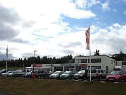
Varmahlíð [ ˈvarmal̥iˑð ] ( Eng . "Warm slope") is a small place in the Icelandic municipality Skagafjörður in the region Norðurland vestra with 132 inhabitants (as of January 1, 2019).
geography
Varmahlíð is located in a thermal area with greenhouses. The place is at the foot of the forested hill Reykjarhóll . Víðimýri farm is located about three kilometers to the southwest . The river Víðimýrará flows through this and later flows past Varmahlíð to the west. The Húseyjarhvísl flows east of Varmahlíð, and the mightier Héraðsvötn river even further east .
History and tourism
The place, which has a tree nursery, developed into a service center of the region due to its location as a traffic junction. There is a supermarket with a post office, a fast food restaurant, a gas station, a bank, a tourist information office, a campsite, a swimming pool and a hotel in the village. The place is the seat of a horse riding tour and a rafting tour operator . The nationwide annual horse show Landsmót has already been held several times on the slope Vindheimamelar near Varmahlíð.
traffic
Varmahlíð is located on the ring road ( Hringvegur ), which leads east to Öxnadalsheiði . From Varmahlíð, road 75 leads to Glaumbær and Sauðárkrókur , the largest town in the region.
The distance to Reykjavík is 294 km and to Akureyri there are 94 km.
literature
- Jens Willhardt, Christine Sadler: Iceland. 3rd updated and revised edition. Michael Müller, Erlangen 2003, ISBN 3-89953-115-9 , p. 463ff.
Individual evidence
- ↑ a b Jens Willhardt, Christine Sadler: Iceland. 3rd updated and revised edition. Michael Müller, Erlangen 2003, ISBN 3-89953-115-9 , p. 465f.

