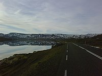
Seyðisfjarðarvegur
| Main Road 93 Iceland |
|||||||||||||||||||||||||||||||||||||||||||||||||
| Seyðisfjarðarvegur | |||||||||||||||||||||||||||||||||||||||||||||||||

|
|||||||||||||||||||||||||||||||||||||||||||||||||
| map | |||||||||||||||||||||||||||||||||||||||||||||||||
| Basic data | |||||||||||||||||||||||||||||||||||||||||||||||||
| Operator: | Vegagerðin | ||||||||||||||||||||||||||||||||||||||||||||||||
| Start of the street: |
Egilsstaðir Hringvegur ( 65 ° 16 ′ N , 14 ° 23 ′ W ) |
||||||||||||||||||||||||||||||||||||||||||||||||
| End of street: |
Seyðisfjörður Hánefsstaðavegur ( 65 ° 16 ′ N , 14 ° 0 ′ W ) |
||||||||||||||||||||||||||||||||||||||||||||||||
| Overall length: | 27.26 km | ||||||||||||||||||||||||||||||||||||||||||||||||
| Development condition: | asphalted | ||||||||||||||||||||||||||||||||||||||||||||||||
| Seyðisfjarðarvegur at Heiðarvatn | |||||||||||||||||||||||||||||||||||||||||||||||||
|
Course of the road
|
|||||||||||||||||||||||||||||||||||||||||||||||||
The Seyðisfjarðarvegur is a main road in the east of Iceland . It is the only road connection from Egilsstaðir and the other parts of the country to Seyðisfjörður .
The road ![]() is 27 km long and paved along its entire length. It starts in Egilsstaðir on the ring road . After about 10 km it turns east. Straight ahead to the north the Borgarfjarðarvegur leads
is 27 km long and paved along its entire length. It starts in Egilsstaðir on the ring road . After about 10 km it turns east. Straight ahead to the north the Borgarfjarðarvegur leads ![]() to Borgarfjörður eystri . On the Fjarðarheiði , the Seyðisfjarðarvegur rises to an altitude of 620 meters. The traffic and road conditions as well as the weather are observed in two places with three webcams each. In Seyðisfjörður the road turns north in the direction of Vestdalseyrarvegurs
to Borgarfjörður eystri . On the Fjarðarheiði , the Seyðisfjarðarvegur rises to an altitude of 620 meters. The traffic and road conditions as well as the weather are observed in two places with three webcams each. In Seyðisfjörður the road turns north in the direction of Vestdalseyrarvegurs ![]() on the north bank of the fjord and then turns to the ferry terminal of the Norröna . The Seyðisfjarðarvegur ends at Hánefsstaðavegur
on the north bank of the fjord and then turns to the ferry terminal of the Norröna . The Seyðisfjarðarvegur ends at Hánefsstaðavegur ![]() on the south bank of the fjord. Hánefsstaðir was the first trading post in this fjord around 1800. Both roads are spur roads and do not lead further into the neighboring fjords.
on the south bank of the fjord. Hánefsstaðir was the first trading post in this fjord around 1800. Both roads are spur roads and do not lead further into the neighboring fjords.
The street has had its name and number since 1972. In addition to the current 124 m long bridge over the Eyvindará from 2001, there is also its predecessor from 1919, which was only 16 m long. The largest volume of traffic on this road is in the summer months on Thursday morning when the Norröna ferry from the Faroe Islands and Denmark docks. Due to the weather and the great height of the pass, the road can be impassable and closed for days in winter. The TV series Trapped was about such a situation . That is why test drillings were carried out in the summer of 2016 to find out how a Fjarðarheiðargöng or Seyðisfjarðargöng could be built. At 13.5 km it will be the longest tunnel in Iceland .
See also
Web links
- Webcam at Fjarðarheiði looking west
- Webcam at Mjósund looking east
Individual evidence
- ↑ Vegaskrá 2018 - kaflaskipt. Retrieved August 22, 2019 (Icelandic).
- ↑ Bundið slitlag á þjóðvegum 2019. Retrieved July 23, 2020 (Icelandic).
- ↑ a b c d Hæð nokkurra vega yfir sjó. Retrieved November 1, 2017 (Icelandic).
- ↑ Hæð nokkurra vega yfir sjó. Retrieved November 1, 2017 (Icelandic).
- ^ Iceland Road Guide, 1988, p. 342
- ↑ Brúaskrá - Brýr utan þjóðvega (February 2016). Retrieved August 22, 2019 (Icelandic).
- ↑ Sænskir bormenn leita að stæði fyrir munna Fjarðarheiðaganga. Retrieved August 24, 2019 (Icelandic).

