Borgarfjardarvegur
| Main Route 94 Iceland |
|||||||||||||||||||||||||||||||||||||||||||||||||||||||||||||
| Borgarfjardarvegur | |||||||||||||||||||||||||||||||||||||||||||||||||||||||||||||

|
|||||||||||||||||||||||||||||||||||||||||||||||||||||||||||||
| map | |||||||||||||||||||||||||||||||||||||||||||||||||||||||||||||
| Basic data | |||||||||||||||||||||||||||||||||||||||||||||||||||||||||||||
| Operator: | Vegagerðin | ||||||||||||||||||||||||||||||||||||||||||||||||||||||||||||
| Start of the street: |
Seyðisfjarðarvegur ( 65 ° 48 ′ N , 14 ° 24 ′ W ) |
||||||||||||||||||||||||||||||||||||||||||||||||||||||||||||
| End of street: |
Borgarfjörður ( 65 ° 16 ′ N , 14 ° 1 ′ W ) |
||||||||||||||||||||||||||||||||||||||||||||||||||||||||||||
| Overall length: | 68.17 km | ||||||||||||||||||||||||||||||||||||||||||||||||||||||||||||
| View from the pass road Vatnsskarð eystra to the bay Njarðvík | |||||||||||||||||||||||||||||||||||||||||||||||||||||||||||||
|
Course of the road
|
|||||||||||||||||||||||||||||||||||||||||||||||||||||||||||||
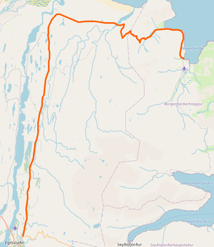
The Borgarfjarðarvegur is a main road in the east of Iceland .
The road begins northeast of Egilsstaðir , where the Seyðisfjarðarvegur ![]() branches off to the east
branches off to the east ![]() . It initially runs north for about 36 km. The solid road surface ends behind the town of Eiðar with the transmitter mast . It stays that way until Hjaltastaðarvegur
. It initially runs north for about 36 km. The solid road surface ends behind the town of Eiðar with the transmitter mast . It stays that way until Hjaltastaðarvegur ![]() . From the west the Lagarfossvegur flows into the street
. From the west the Lagarfossvegur flows into the street ![]() from the waterfall and Hróarstunga . Then it turns east and bridges the Selfljót, which could already be seen east of the road.
from the waterfall and Hróarstunga . Then it turns east and bridges the Selfljót, which could already be seen east of the road.
The asphalt ends again before the climb to Vatnsskarð . At 431 m, the pass is the highest point on the road. Up here is a station from Vegagerðin to monitor traffic and weather. The section at Njaðvíkurskriður has only been accessible by vehicles since 1950. This route is built on the slope. On one side is the sea, on the other side there can be rockfalls. Then the valley opens with the place Bakkagerði . Borgarfjarðarvegur ends here. The further course is the Desjarmýrarvegur ![]() , which leads to the port. The Hólalandsvegur branches off to the south
, which leads to the port. The Hólalandsvegur branches off to the south ![]() . This later becomes Loðmundarfjarðarvegur
. This later becomes Loðmundarfjarðarvegur ![]() and after 27 km it reaches the abandoned Loðmundarfjörður .
and after 27 km it reaches the abandoned Loðmundarfjörður .
The distance between Bakkagerði and Egilsstaðir is 71 km, of which 28 km are not yet paved. The asphalting work on Njaðvíkurskriður was completed in August 2019. In 2020 the path over Vatnsskarð will also be paved.
See also
Web links
Individual evidence
- ↑ Vegaskrá 2018 - kaflaskipt. Retrieved August 29, 2019 (Icelandic).
- ↑ a b Brúaskrá - Brýr á þjóðvegum (February 2016). Retrieved September 5, 2019 (Icelandic).
- ↑ Hæð nokkurra vega yfir sjó 22.12.2010. Retrieved September 6, 2019 (Icelandic).
- ↑ Bakkagerði-Egilsstaðir. Retrieved September 6, 2019 (Icelandic).
- ↑ Búið að malbika Njarðvíkurskriður. Retrieved September 7, 2019 (Icelandic).
- ↑ Framkvæmdir 2019 - Helstu verk sem unnið er að á árinu 2019. Accessed September 7, 2019 (Icelandic).

