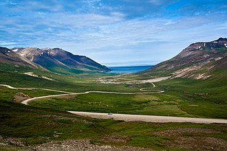
Vatnsskarð eystra
| Vatnsskarð eystra | |||
|---|---|---|---|
|
View from the pass road Vatnsskarð eystra to the bay Njarðvík |
|||
| Compass direction | west | east | |
| Pass height | 431 m | ||
| region | Austurland | ||
| Watershed | Lagarfljót | ||
| Valley locations | Fljótsdalshérað | Bakkagerdi | |
| expansion | Pass road | ||
| Mountains | Dyrfjöll | ||
| Map (Austurland) | |||
|
|
|||
| Coordinates | 65 ° 33 '43 " N , 13 ° 59' 35" W | ||
Vatnsskarð eystra is a mountain pass in the Austurland region in eastern Iceland .
The pass is at Njarðvík on the way to Bakkagerði on Borgarfjörður eystri . The Borgarfjarðarvegur runs over it and ![]() leads from Egilsstaðir and the Héraðsflói bay over the Dyrfjöll and into the east fjords .
leads from Egilsstaðir and the Héraðsflói bay over the Dyrfjöll and into the east fjords .
The pass road is steep and unpaved and can be difficult to drive in rainy weather or in winter. At its highest point it reaches 431 m.
literature
- Vegahandbókin , Landmælingar Íslands, 2004, ISBN 9979-9750-0-8
Web links
- Webcam of the Icelandic road watch in northwest direction over Hróarstunga
- Webcam of the Icelandic road watch heading east

