Dyrfjöll
| Dyrfjöll | ||
|---|---|---|
|
Dyrfjöll behind the lake Lögurinn (in the background, middle) |
||
| height | 1136 m | |
| location | Austurland , Iceland | |
| Coordinates | 65 ° 31 ′ 0 ″ N , 13 ° 57 ′ 0 ″ W | |
|
|
||
| Type | Central volcano (extinct) | |
| Age of the rock | approx. 12–3 million years | |
| Last eruption | about 3 million years ago | |
| First ascent | around 1900 | |
| particularities | Scharte divides the mountain range into two parts | |
|
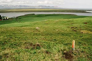
View from the foot of Dyrfjöll over the bay of Héraðsflói |
||
The Dyrfjöll ( Icelandic Door Mountains ) are a mountain range in northeast Iceland .
This mountain range is located west of Borgarfjörður eystri and east of the municipality of Fljótsdalshérað .
Surname
They get their name Türberge from the cut Dyr, 856 m high, which is shaped like a gate.
More detailed description of the Dyrfjöll
The mountain range is one of the oldest parts of Iceland and was formed around 12 million years ago when this part of the island was above the hot spot .
The highest peak is the Súlur in Ytra-Dyrfjall with a height of 1137 m. It can be climbed from the side of Borgarfjörður eystri, which was first done in 1952 by three locals u. a. Jón Sigurðsson from Sólbakki.
A lower peak, Dyrfjallstindur (1025 m), is often climbed from the same side. The first to climb Dyrfjöll were probably Norwegians shortly after 1900.
From the side of Borgarfjörður, the valley of Jökuldalur extends under the cut called Dyr (Eng. Door ). Its bottom is glaciated in the upper part.
On the northern side of Fljótsdalshérað you can clearly see the traces of a major landslide caused by glacial erosion during the Ice Age. Hiking trails lead to this so-called Stórurð . The landslide is 4 to 5 km long. The largest boulders are the size of a large house.
Central volcano from the Tertiary
The central volcano Dyrfjöll originated in the Tertiary and consists of different, clearly separated layers.
Five different phases of the structure were determined: First, the basalt layers emerged, which are visible at the bottom, for example on the steep erosion slopes of the so-called Njarðvíkur Skriður , which drop steeply into the sea on the south side of the mountain range. The individual layers of lava are believed to have flowed down the slopes of a shield volcano.
The next phase produced rocks with a high SiO2 content both as intrusions and as layers of lava and ash. One recognizes some such rhyolite intrusions in the basalt layers e.g. B. up in Skjaldarfjall . In some places where liparite lavas emerged, obsidian is also found , e.g. B. in the uppermost layers of Grjótfjall . The Hvannagil Gorge offers a particularly good view of the up to 200 m thick rhyolite layers . In between you can also discover ignimbrite and charcoal layers .
During the third active phase of the volcano again, he produced mainly basalt, which, however, sometimes of intermediate Islandit - and dacite is pierced -Gestein.
In the fourth phase, a large explosive eruption resulted in a small caldera at the point where the Dyrfjöll are today. The outbreak was mainly reflected in thick layers of ignimbrite. Only a small part of this caldera still exists in the form of the Tindfell south of the Dyrfjöll.
After the magma chamber had collapsed, a lake formed on the bottom of the caldera, and in this eruption under water, today's Dyrfjöll, which mainly consists of palagonite and pillow lavas , was created.
The eruptions continued until about 3 million years ago. Then the erosion forces of the Ice Age glaciers shaped the landscape.
Transport links
Until the middle of the 20th century, the area around Borgarfjörður eystri was one of the most remote in Iceland. However, this improved noticeably with the completion of the road connection over the Vatnskarð pass in 1954.
Vegetation
17 species of flowers were found at altitudes above 1,100 meters.
See also
literature
- Lúðvík Ekart Gustafsson: Geology and Petrography of the Dyrfjöll Central Volcano Eastern Iceland. Berlin 1992
Web links
- http://www.borgarfjordureystri.is/Myndir-Storurd.htm Off. Website, Borgarfjörður eystri, with landscape photos
- http://www.nat.is/travelguide/ahugav_st_dyrfjoll.htm (Icelandic with photo)
- http://www.nat.is/gonguleidirisl/gonguleidir_viknaslodir11_12.htm Hiking map of the area around Dyrfjöll, Stórurð left, not quite legible
- http://www.flickr.com/photos/johannakh/4957988635/ Photo Stórurð
Individual evidence
- ↑ a b Íslandshandbókin, Náttúra, saga og sérkenni. 2. bindi. Edited by T. Einarsson, H. Magnússon. 1989 p. 568.
- ↑ a b c Hjörleifur Guttormsson: Útihérað. Ferðafélag Íslands, árbók 2008, p. 80.
- ^ HU Schmid: Dictionary Icelandic-German . Hamburg 2001, p. 44.
- ↑ Hjörleifur Guttormsson: Útihérað. Ferðafélag Íslands, árbók 2008, p. 89.
- ↑ after: Hjörleifur Guttormsson: Útihérað. Ferðafélag Íslands, árbók 2008, pp. 88/89.
- ↑ Hjörleifur Guttormsson: Útihérað. Ferðafélag Íslands, árbók 2008, p. 60.


