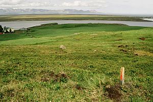
Héraðsflói
| Héraðsflói | ||
|---|---|---|
|
The bay in the background in front of the Kollamúli |
||
| Waters | Atlantic Ocean | |
| Land mass | Iceland | |
| Geographical location | 65 ° 40 ′ 9 ″ N , 14 ° 11 ′ 12 ″ W | |
|
|
||
| Tributaries | Jökulsá á Brú , Lagarfljót | |
The Héraðsflói is a wide, not far inland bay in northeast Iceland in front of the Hróarstunga region .
Characteristics
The wide bay, open to the northeast, is framed by mountain ranges in the northwest and southeast, with the northwestern mountain range Fagradalsfjöll, for example at the cape with the Kollamúli volcano, being characterized by colorful rhyolite rocks, while the southeast lying Dyrfjöll (= Isl. "Türberge") is more likely have an alpine character. The name of the mountains, which can be clearly recognized by their shape, comes from an enormous indentation in their middle, which was created by a prehistoric landslide.
Further surroundings
Behind these mountains lie the town of Vopnafjörður in the northwest and Bakkagerði on Borgarfjörður Eystri , southeast of Dyrfjöll , a well-known hiking area with colorful mountains.
Rivers
The two rivers Jökulsá á Brú and Lagarfljót , which converge shortly before the mouth, flow into this bay . Jökulsá á Brú is dammed at Kárahnjúkar .
Additional income for the farmers
One source of income in this bay is driftwood.

