Núpsvötn
| Núpsvötn | ||
|
View from the bridge over the river, Lómagnúpur li. and Skeiðarárjökull right. |
||
| Data | ||
| location | Iceland | |
| River system | Núpsvötn | |
| origin | Confluence of the Núpsá and Súla rivers 63 ° 59 ′ 31 ″ N , 17 ° 28 ′ 55 ″ W |
|
| muzzle | in the Atlantic Ocean , south coast of Iceland, Skeiðarársandur Coordinates: 63 ° 44 ′ 58 ″ N , 17 ° 30 ′ 16 ″ W 63 ° 44 ′ 58 ″ N , 17 ° 30 ′ 16 ″ W
|
|
| length | 35 km | |
| Drain |
MNQ MHQ HHQ (1996) |
30 m³ / s 100 m³ / s 2300 m³ / s |
|
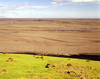
View from the foot of Lómagnúpur to Skeiðarársandur with Núpsvötn and the bridge of Hringvegur |
||
In Núpsvötn is a major glacial river in the south of Iceland .
As is usual with glacier rivers, especially in the area affected by volcanoes, its water flow fluctuates greatly.
The highest in its range, i.e. H. on the sand , measured water volume was 45,000 m³ / s during the course of the glacier due to the volcanic eruption in Gjálp 1996. However, under the bridge and thus in the Núpsvötn itself, only a high of 2,300 m³ / s was measured, most of the glacier flow over the River beds from Skeiðará and Gígjukvísl .
location
The river is located on the Skeiðarársandur plain to the east of Mount Lómagnúpur . It flows over a length of about 35 km - it is changeable because the course of the river is subject to great changes again and again - over the westernmost side of the sander along the mountain Lómagnúpur and from there to the sea.
According to old sources, two rivers ran here until about 200 years ago. On the one hand, it was the Lómagnúpsá river, a source river on the Lómagnúpur mountain. This was later renamed Núpsá. On the other hand, the glacier river Súluá, which is now called Súla, ran a little further to the east .
The two rivers merged about 200-300 years ago after the glaciers had advanced during the Little Ice Age and have been called Núpsvötn since then.
Transport links
A 420 m long bridge, the Súlubrú, has been running slightly southeast of the Lómagnúpur over the river since 1974, which is crossed by the Hringvegur at this point . It survived the 1996 glacier run unscathed.
Origins
The main source rivers are Núpsá and Súla, both of which have their origins in valley glaciers on the southern edge of Vatnajökull . Both flow a few kilometers north of the Lómagnúpur on the southern edge of the Skeiðarárjökull and form the Núpsvötn. However, the rivers have often changed their path and with it the place where they meet.
Núpsá
The Núpsá River has its sources on Grænalónsjökull and the volcanic mountain range Hágöngur . From there it flows more or less directly to the south. He brushes the forest area Núpsstaðaskógur, which is accessible by highland jeep . In the inner valley, an impressive gorge, you can find u. a. beautiful waterfalls, the Núpsárfoss and the Hvítárfoss.
At the beginning of the 20th century the Núpsá had its origin in the glacial lake Grænalón . However, this changed with the increasing melting of the glaciers.
Súla
The other tributary, Súla, is a pure glacial river and comes from the Skeiðarárjökull . The small glacier runs from the Grænalón glacial lake into the Núpsvötn regularly pour over it .
The more extensive glacier run from the Grímsvötn in 2010 partly took this route.
See also
literature
- Hjörleifur Guttormsson, Oddur Sigurðson: Leyndardómur Vatnajökuls. Viðerni, fjöll and byggðir. Stórbrotin náttúra, eldgos og jökulhlaup. Reykjavík (Fjöll og firnindi) 1997 ISBN 9979-60-325-9
Web links
- Photo: Grænalón
- Coordinates (at Lómagnúpur): 63 ° 59 ′ 31 ″ N , 17 ° 28 ′ 55 ″ W.
Individual evidence
- ↑ Hjörleifur Guttormsson, 1997, p. 42
- ↑ Hjörleifur Guttormsson, 1997, p. 153
- ↑ Íslandshandbókin. 2. bindi. 1989, p. 712
- ↑ Grein - Bruin yfir Núpsvötn stóðst atlöguna Accessed: December 28, 2010
- ↑ a b Íslandshandbókin. 2. bindi. 1989, p. 712
- ↑ cf. Ísland Vega Atlas. 2006, p. 7
- ↑ cf. Vegahandbókin. Ed. Landmælingar Íslands. 2006, p. 125

