Jökulsá í Lóni
| Jökulsá í Lóni | ||
|
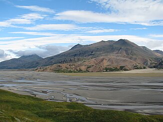
Jökulsá í Lóni in the Lónsöræfi |
||
| Data | ||
| location | Austurland , Iceland | |
| River system | Jökulsá í Lóni | |
| source | Vesturdalsjökull on the eastern edge of Vatnajökull | |
| muzzle | in Lónsfjörður ( Atlantic Ocean ) Coordinates: 64 ° 21 ′ 40 ″ N , 14 ° 49 ′ 30 ″ W 64 ° 21 ′ 40 ″ N , 14 ° 49 ′ 30 ″ W |
|
| Mouth height |
0 m
|
|
| length | 46 km | |
| Navigable | No | |
The Jökulsá í Lóni is a glacial river in southeast Iceland .
The river has its source in Vesturdalsjökull on the eastern edge of Vatnajökull . It is 46 kilometers long and flows into the Lónsfjörður . About nine kilometers before the mouth, the ring road with the only road bridge leads over the Jökulsá í Lóni.
Behind the end of the Kollumúlavegur ![]() near Illakambur, a 70 year old pedestrian suspension bridge led across the river to the Múlaskáli hut. It collapsed in a storm in January 2019 and was then replaced by a new one in July.
near Illakambur, a 70 year old pedestrian suspension bridge led across the river to the Múlaskáli hut. It collapsed in a storm in January 2019 and was then replaced by a new one in July.
Individual evidence
- ↑ Bruin í Lónsöræfum hrunin. Retrieved July 3, 2019 (Icelandic).
- ^ New Walking Bridge Over Jökulsá í Lóni. Retrieved July 3, 2019 .
