
Berufjörður (Austfirðir)
| Berufjörður in East Iceland | ||
|---|---|---|
 |
||
| location | Austurland , Iceland | |
| Geographical location | 64 ° 41 ′ N , 14 ° 17 ′ W | |
|
||
| Type | Fjord | |
| length | 35 km | |

The Berufjörður is about 35 km long fjord in East Iceland . It extends from the fishing village of Djúpivogur in a north-westerly direction inland.
Until recently there was a salmon farm in the fjord . Ships took care of the care and transport of the fish. Otherwise, the fjord is considered difficult to navigate for shipping due to numerous shallows.
Breiðdals volcano and glacial cut
On the east bank are the remains of the large tertiary Breiðdal volcano , whose chimneys are clearly visible in good weather. They consist mainly of the rhyolite rock typical of central volcanoes and therefore have a beige and reddish glow, sometimes also mixed with dark basalt intrusions . Often, however, these rugged peaks are hidden under clouds. The highest peaks reach up to 1200 m. Like all mountains in the east fjords, they were ground down by the Ice Age glaciers , which rested on this part of Iceland for a particularly long time (until around 10,000 years ago).
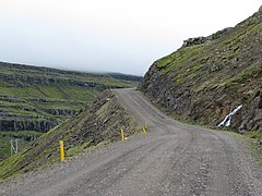
The pass road Axarvegur or Öxi

Berufjörður with Búlandstindur from Djúpivogur
Búlandstindur at Berufjörður


Berufjörður from the Teigarhorn


Berufjörður from Öxi

traffic
The Hringvegur circles the fjord. Around Djúpivogur and in the direction of Höfn ( Hvalnesskríður ) there are still some of the few unpaved parts of the ring road.
The 19 km long Axarvegur ( Öxi ), which branches off inside the fjord, can shorten the route between Djúpivogur and Egilsstaðir to 85 km. Over the Breiðdalsheiði on the previous Hringvegur the distance is 146 km. Before the original piste was expanded, this shortcut over the Öxi did not save time due to poor traffic conditions. Even today the road is always closed in winter.
The Öxi path is still unpaved for the time being, just better paved and widened. Currently (as of January 2008) there is still a discussion about whether it should be expanded into an all-year path in the near future and thus be paved. Isolation of the eastern fjords would be a possible disadvantage; In Breiðdalsvík in particular, the alternative route across Breiðdalsheiði (inside the Breiðdalsvík bay) to Egilsstaðir is preferred.
Old yards
The Berunes Youth Hostel is located on the east bank of the fjord .
There is also a farm of the same name in the fjord, where Eiríkur Magnússon (1833–1913) was born in the 19th century and became a Cambridge librarian .
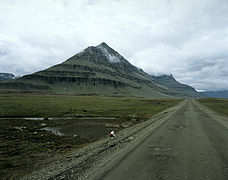
Búlandstindur and Teigarhorn
The pyramid-shaped, over 900 m high summit Búlandstindur on the west bank also owes its shape to fire and ice. At his feet, on the so-called Teigarhorn, is an important site of the mineral calcite , also known as "Iceland spar" , which is known in optics for its double refraction of light and which is why it was mined here. The place is under nature protection.