Akranes
| Basic data | |
|---|---|
| State : |
|
| Region: | Vesturland |
| Constituency : | Norðvesturkjördæmi |
| Sýsla : | circular |
| Population: | 7411 (January 1, 2019) |
| Surface: | 9 km² |
| Population density: | 823.44 inhabitants / km² |
| Post Code: | 300, 301, 302 |
| politics | |
| Community number | 3000 |
| Mayor: | Regína Ásvaldsdóttir |
| Contact | |
| Address of the municipal administration: | Stillholti 16-18 300 Akranesi |
| Website: | www.akranes.is |
| map | |

Coordinates: 64 ° 19 ′ N , 22 ° 4 ′ W |
|
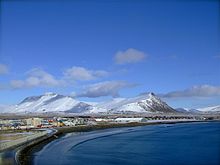
Akranes [ 'aːkraˌnɛˑs ] is a port city in Iceland north of Reykjavík in the Vesturland region . On January 1, 2019, the city had 7,411 inhabitants. This makes it the largest city in West Iceland.
Name and geography
The name of the city means Kornacker Peninsula . This name can be found in very old sources and can therefore be assumed that a lot of grain was planted in the area during the Viking Age.
The tip of the peninsula where the present city is located was formerly called Skagi (German: peninsula ) and from the 17th century Skipskagi or Skipaskagi . Colloquially, the name Skagi is still often used for Akranes, especially in West Iceland.
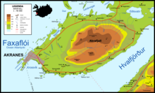
To the east of Akranes is Mount Akrafjall , on the south side of which is Innrihólmur . Akranes is located on the large Faxaflói bay , the southern part (around Langisandur) on the much smaller Krossvík bay , which belongs to Hvalfjörður .
history
First settlers
The area is since the Conquest settled Islands.
The land register reports that the Irish brothers Þormóður gamli Bresason and Ketill Bresason came to Iceland from Ireland and took possession of the land between the rivers Aurríðaá and Kalmansá . Some farm names in the area refer to other Irish settlers such as B. Kjaranstaðir, Kalmansvík, Bekanstaðir.
Role of fishing and the Hanseatic League
Presumably this was a place of fishing from ancient times, but there is evidence of a winter fishing village of the Bishop of Skálholt Brynjólfur Sveinsson from the middle of the 17th century. Soon afterwards the first fishing village in Iceland was built here. Even today, fishing and processing play a very important role as an employer in Akranes, which is one of the main fishing locations in the country.
In the Middle Ages, the Hanseatic League also had a base in the Krossvík Bay until 1602 . With the introduction of the Danish trade monopoly, however, the people of Akranes were forced to conduct their business at Hólminn near Reykjavík.
Urban development
Akranes developed from this fishing village in the 19th century and was granted market rights in 1864. At that time the town had 300 inhabitants.
The first jetties date from 1874, and port facilities were built in the Krossvík Bay in 1929. And there is still the port, which is one of the most important fishing ports in Iceland.
The church was moved from Garðar to Akranes in 1896.
Akranes received city charter in 1941 and is one of the largest cities in Iceland outside the capital region.
Culture and sights
Akranes Museum Grounds
Akranes has a relatively large open-air and local museum ( Safnasvæðið á Akranesi , formerly: Museum in Garðar ). This includes a mineral collection and a boat and fishing museum, which includes Iceland's oldest surviving fishing trawler. Other larger sections of the museum include: a section on sports in Iceland and a section of the National Surveying Institute and tunneling under nearby Hvalfjörður , the importance of which should not be underestimated for the prosperity of the city of Akranes. .
Lighthouses
Also worth seeing are the lighthouses built in 1918 (restored in 1992) and 1946. A modern sculpture commemorates the sinking of the Hafmeyjan ship , in which 11 young people were killed in 1905.
festival
Because of the history of settlement, Akranes feels connected to Ireland. The Írskir dagar festival is therefore held once a year in Akranes.
Sports
Akranes is also considered one of the cities where sport holds a particularly high place.
The football club ÍA Akranes has won multiple Icelandic championships and cups and has played many UEFA Cup games.
Part of the museum in Garðar is dedicated to Icelandic sport.
education
There are several schools on site, including elementary schools and a secondary school ( Fjölbrautaskóli Vesturlands ).
Economy and Infrastructure
Iceland's largest cement plant processes shell limestone in Akranes. A well-known joke says that there are two architectural styles in Iceland: before and after the Akranes cement plant was built.
One lives from fishing and processing, but now also increasingly from the service area. In addition, thanks to the Hvalfjörður tunnel, which has existed since 1998, many residents commute to work in Reykjavík.
The hot water for heating and daily use comes from the largest spring in the country, Deildartunguhver , and is piped to Akranes via approx. 60 km long pipes.
Population development
| date | Residents |
|---|---|
| Dec. 1, 1981: | 5,267 |
| Dec. 1, 1997: | 5,127 |
| Dec. 1, 2003: | 5,582 |
| Dec. 1, 2004: | 5,655 |
| Dec. 1, 2005: | 5,782 |
| Dec. 1, 2006: | 5,955 |
| Dec. 1, 2007: | 5,976 |
| Dec. 1, 2008: | 6,401 |
| Dec. 1, 2009: | 6,609 |
| Dec. 1, 2010: | 6,549 |
Town twinning
-
 Bamble , Norway
-
 Narpes , Finland
-
 Qaqortoq , Greenland
-
 Sörvágur , Faroe Islands
-
 Tønder , Denmark
-
 Västervik , Sweden
sons and daughters of the town
- Jón Óskar (1921–1998), poet and translator
- Ríkharður Jónsson (1929–2017), football coach, manager and player
- Guðbjartur Hannesson (1950–2015), politician
- Edda Heiðrún Backman (1957–2016), actress, director and painter
- Pétur Pétursson (* 1959), football player
- Þórður Guðjónsson (* 1973), football player
- Sigurbjörg Þrastardóttir (* 1973), writer
- Gunnleifur Gunnleifsson (* 1975), football player
- Bjarni Guðjónsson (* 1979), football player
- Garðar Gunnlaugsson (born 1983), football player
- Arnór Smárason (* 1988), football player
- Arnór Sigurðsson (* 1999), football player
Transport links
Since 1998 Akranes has been connected to Reykjavík via national road 1 ( Hringvegur ), more precisely its part called Vesturlandsvegur , through the Hvalfjarðargöng tunnel , which runs under Hvalfjörður . From the tunnel, road no.501 leads to Akranes and on the north side around Mount Akrafjall, while Hringvegur runs south past the mountain towards Borgarnes.
Before the tunnel was built, there was only a ferry connection and a poor cross-country route to Reykjavík.
See also
Web links
Photos and videos
Other
- German-language website of the city administration ( Memento from August 19, 2014 in the Internet Archive )
- City administration website (Icelandic)
Individual evidence
- ↑ See HU Schmid: Dictionary Icelandic-German. Buske, Hamburg 2001, 3; Buske translates acurately as field in general, but since only grain was planted in Iceland in the Middle Ages, in cases like this it is translated as corn field ; see. also Akureyri .
- ↑ a b c d e f Íslandshandbókin. Náttúra, saga og sérkenni. 1. bindi. Edited by T. Einarsson, H. Magnússon. Örn and Örlygur, Reykjavík 1989, 100
- ↑ cf. HU Schmid: Dictionary Icelandic-German. Buske, Hamburg 2001, 215
- ↑ See e.g. B. http://visir.is/ludarnir-fara-upp-a-skaga/article/200660914091 Lúðarnir fara upp á Skaga. , Article in the daily Vísir on September 14, 2006; here the term Skipaskagi is used synonymously (Icelandic); Accessed July 3, 2001
- ↑ Landmælingar Íslands: Vegahandbókin. 2007, p. 234
- ↑ Myndmæling á cutter Sigurfara . Akranes Folk Museum , April 13, 2018, accessed March 15, 2019 (Icelandic).
- ↑ cf. German-language website of the museum; ( Memento of October 4, 2013 in the Internet Archive ) Accessed: July 3, 2011
- ↑ Írskir dagar á Akranesi ( Icelandic ) irskirdagar.is. February 5, 2006. Archived from the original on February 5, 2006. Retrieved June 19, 2010.
- ↑ http://www.fva.is/ website of Fjölbrautaskóli Vesturlands (English); Accessed July 3, 2011


