Stokkseyri
| Stokkseyri | ||
|---|---|---|
|
|
||
| Coordinates | 63 ° 54 ′ N , 21 ° 5 ′ W | |
| Basic data | ||
| Country | Iceland | |
| Southurland | ||
| ISO 3166-2 | IS-8 | |
| local community | Árborg | |
| Residents | 515 (January 1, 2019) | |
|
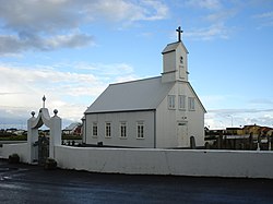
Stokkseyrarkirkja
|
||
Stokkseyri is a fishing village in the south of Iceland .
The Gaulverjabæjarvegur ![]() runs through the village. In the eastern part it is called Hásteinsvegur in town, then Eyrarbraut. The place belongs to the municipality of Árborg and has 515 inhabitants (as of January 1, 2019) . The driving distance to Selfoss is just under 2 km. To the west it is 6 km to Eyrarbakki . From May 18, 1897 to June 7, 1998 there was an independent municipality Stokkseyri ( Stokkseyrarhreppur ). About 4 km east of Stokkseyri you can visit Rjómabúið Baugsstaðir , the country's last remaining small dairy .
runs through the village. In the eastern part it is called Hásteinsvegur in town, then Eyrarbraut. The place belongs to the municipality of Árborg and has 515 inhabitants (as of January 1, 2019) . The driving distance to Selfoss is just under 2 km. To the west it is 6 km to Eyrarbakki . From May 18, 1897 to June 7, 1998 there was an independent municipality Stokkseyri ( Stokkseyrarhreppur ). About 4 km east of Stokkseyri you can visit Rjómabúið Baugsstaðir , the country's last remaining small dairy .
Þuríðarbúð
In Stokkseyri the Þuríðarbúð was built in 1949 in Strandgata, roughly at the point where Þuríður Einarsdóttir (1777–1863) had her fishing hut. Þuríður, usually called Þuríður formaður ( foreman Þuríður , boat driver ), was one of the few women who went fishing at the time. For almost half a century until 1843 she went fishing, mostly as a foreman. A peat house was rebuilt for this small fishing museum , as was common in the 19th century.
Sons and daughters of the place
- Páll Ísólfsson (1893–1974), composer, organist, teacher and conductor
Individual evidence
- ↑ Stokkseyri-Selfoss. Retrieved April 14, 2020 (Icelandic).

