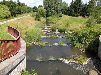
Schnnauder
| Schnnauder | ||
| Data | ||
| Water code | DE : 56658 | |
| location | Germany ( Saxony-Anhalt , Thuringia , Saxony ) | |
| River system | Elbe | |
| Drain over | White Elster → Saale → Elbe → North Sea | |
| source | Pool in Hirschfeld (Thuringia) 50 ° 56 ′ 29 ″ N , 12 ° 10 ′ 52 ″ E |
|
| Source height | 280 m above sea level NN | |
| muzzle | near Groitzsch , district Audigast in the White Elster Coordinates: 51 ° 10 ′ 51 ″ N , 12 ° 17 ′ 1 ″ E 51 ° 10 ′ 51 ″ N , 12 ° 17 ′ 1 ″ E |
|
| Mouth height | 127 m above sea level NN | |
| Height difference | 153 m | |
| Bottom slope | 3 ‰ | |
| length | 51.6 km | |
| Catchment area | 257.4 km² | |
| Drain at the weir Audigast gauge |
MQ |
500 l / s |
| Left tributaries | Stockhausener Graben, Rainbach, Schlunger Bach, Schwennigke | |
| Right tributaries | Nißmaer Graben, Saalgraben | |
| Small towns | Meuselwitz , Lucka , Groitzsch | |
The Schnauder is a river around 52 kilometers long, the two arms of which, the Große and Kleine Schnauder, arise in the Altenburg-Zeitz loess hill country.
course
The source streams, which are regionally also called Kaynaer and Lindenberger Schnauder , unite halfway up between Loitsch and Spora near the former Gera-Meuselwitz railway line, still south of Oelsen. Continuing via Meuselwitz , the now unified Schnauder crosses the plains of the Leipzig lowland bay and flows into the White Elster near a district of Groitzsch . From the source to the mouth, the river crosses the three federal states of Saxony-Anhalt, Thuringia and Saxony.
The Kaynaer Schnauder rises at Beiersdorf in Thuringia, it performs an annual average more water than the small re in Heuckewalde springing Lindenberger Schnauder . The latter is also referred to as Lindenbergsche Schnauder in some publications, following a different form of adjectivation of the city name .
Drain
The mean discharge of the Schnauder at the Audigast weir about 1.5 kilometers above the mouth is about 0.50 m³ / s. Since there are no long-term level observations for the Schnauder, only the mean discharge can be given. The value was calculated and should therefore only be classified as an orientation.
history
The river was already known as Snudra in 1105 , which goes back to the Old High German Snudra-aha . This means something like flowing water . In 1831 there were 31 watermills on the river.
Between Wildenhain and Groitzsch, the course of the river is routed in an eight-kilometer-long canal due to lignite mining .
literature
- The Altenburger Land . In: Academy of Sciences of the GDR (ed.): Values of our homeland . tape 23 . Akademie-Verlag, Berlin 1973, DNB 740153579 , A 1, p. 34 .
- Miles & measurement table sheets & equidistant map of Saxony (1780-1942) on: deutschefotothek.de
Web links
Individual evidence
- ↑ Environmental report 1999-2009 ( Memento of the original from June 21, 2015 in the Internet Archive ) Info: The archive link was inserted automatically and has not yet been checked. Please check the original and archive link according to the instructions and then remove this notice. District Office Altenburger Land; April 2010; On: altenburgerland.de (pdf; 14.0 MB)
- ↑ Thuringian State Institute for the Environment (ed.): Area and water code index and map. Jena 1998; 26 pp.
- ↑ a b Environmental report on the “United Schleenhain opencast mine”, section 2.3 Summary inventory of the relevant aspects of the current state of the environment including the environmental characteristics of the areas with likely significant influence , Regional Planning Association Westsachsen, September 26, 2008, page 26, Auf: rpv-westsachsen. de (PDF, German, 2.04 MB)
- ↑ a b zoning plan planning association Zeitz and coll. Municipalities; March 2009; On: zeitz.de (pdf; 844 kB)
- ↑ Schnaudertal news community Schnaudertal; August 2008; On: zeitz.de (pdf; 920 kB)
- ↑ Schnaudertal news community Schnaudertal; October 2010; On: zeitz.de (pdf; 946 kB)
