Russen-Kleinstorkwitz
|
Russen-Kleinstorkwitz
City of Zwenkau
Coordinates: 51 ° 11 ′ 13 ″ N , 12 ° 18 ′ 17 ″ E
|
||
|---|---|---|
| Height : | 134 m | |
| Residents : | 483 (May 9, 2011) | |
| Incorporation : | October 1, 1996 | |
| Postal code : | 04442 | |
| Area code : | 034203 | |
|
Location of Rüssen-Kleinstorkwitz in Saxony |
||
|
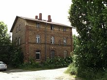
Lindenstrasse in Rüssen
|
||
Rüssen-Kleinstorkwitz has been part of the city of Zwenkau in Saxony since October 1, 1996 . Before that, the community that originally emerged on January 1, 1957 from the connection between Rüssen and Kleinstorkwitz was independent.
Location and traffic
The place is located directly on the federal highway 2 between Zwenkau and Pegau on the right bank of the White Elster . Between 1874 and the closure of the line, Rüssen had a station on the Gaschwitz – Meuselwitz railway line . In 1957 it was renamed "Rüssen-Kleinstorkwitz".
history
Rüssen was first mentioned in 1266 as Ruessin , but the place is much older and was founded as a Slavic Rundling. In the 11th century, German settlers came along who converted the place into a lane village. Little has survived from the old farms.
Kleinstorkwitz, immediately to the south, is also of Slavic origin and emerged as a dead end village . It was first mentioned in 1378 as Storkewicz parva . The place, which stretches in a fan shape around a cul-de-sac, was mainly known for its upper bower houses, of which only one still exists today, but which has already fallen into disrepair. One of the oldest half-timbered houses in the area dates from 1705 . A mighty Art Nouveau villa from the Wilhelmine era is also worth seeing.
While the floodplain was originally forested, agriculture and horticulture soon established itself on the fertile soils. The White Elster was in the middle of the 20th century. straightened. State sovereignty over Rüssen and Kleinstorkwitz lay with Electoral Saxony and until 1918 with the Kingdom of Saxony . Rüssen with its districts Döhlen and Kleinstorkwitz were in the Electoral Saxon and Royal Saxon Office of Pegau until 1856 . From 1856 the places belonged to the court office of Zwenkau and from 1875 to the district administration of Leipzig . Since the beginning of industrialization, the landscape around the two places has been shaped by open-cast lignite mining, which has created a large fallow area east of the B 2. In 1910 there were 226 inhabitants in Rüssen and 104 in Kleinstorkwitz.
On January 1, 1957, the community was formed from the previous communities Kleinstorkwitz and Rüssen with Döhlen. On October 1, 1996 it was incorporated into the city of Zwenkau.
Rüssen-Kleinstorkwitz does not have its own church. There was a primary school in the village, but it was closed a few years ago. Since 2008 there has been a privately owned primary school on the site of the former school, which has renovated the schoolhouse and has been using it again since November 2010, see Döhlen .
Web links
- Rüssen-Kleinstorkwitz in the Digital Historical Directory of Saxony
- Rüssen in the Digital Historical Directory of Saxony
- Kleinstorkwitz in the Digital Historical Directory of Saxony
Individual evidence
- ↑ Small-scale municipality sheet for Zwenkau, city. (PDF; 0.23 MB) State Statistical Office of the Free State of Saxony , September 2014, accessed on February 2, 2015 .
- ↑ Rüssen-Kleinstorkwitz
- ^ Karlheinz Blaschke , Uwe Ulrich Jäschke : Kursächsischer Ämteratlas. Leipzig 2009, ISBN 978-3-937386-14-0 ; P. 62 f.
- ↑ The Amtshauptmannschaft Leipzig in the municipal register 1900
- ↑ Municipalities 1994 and their changes since January 1, 1948 in the new federal states , Metzler-Poeschel publishing house, Stuttgart, 1995, ISBN 3-8246-0321-7 , publisher: Federal Statistical Office
- ^ StBA: Changes in the municipalities in Germany, see 1996


