
Lossatal
| coat of arms | Germany map | |
|---|---|---|

|
Coordinates: 51 ° 24 ' N , 12 ° 52' E |
|
| Basic data | ||
| State : | Saxony | |
| County : | Leipzig | |
| Height : | 144 m above sea level NHN | |
| Area : | 111.15 km 2 | |
| Residents: | 6049 (Dec. 31, 2019) | |
| Population density : | 54 inhabitants per km 2 | |
| Postal code : | 04808 | |
| Primaries : | 034262, 034263 | |
| License plate : | L , BNA, GHA, GRM, MTL, WUR | |
| Community key : | 14 7 29 245 | |
| LOCODE : | DE S2L | |
| Community structure: | 17 districts | |
| Address of the municipal administration: |
Karl-Marx-Str. 14 04808 Lossatal |
|
| Website : | ||
| Mayor : | Uwe Weigelt | |
| Location of the municipality Lossatal in the district of Leipzig | ||
  |
||

Lossatal is a municipality in the Leipzig district in Saxony .
geography
location
Lossatal is east of Leipzig and northeast of Wurzen . The eponymous Lossa flows through the municipality through Müglenz, Hohburg, Klein- and Großzschepa to the Mulde . Falkenhain lies on the western edge of the Dahlener Heide . Around the place Hohburg are the Hohburg mountains with the 240 m high Löbenberg .
Neighboring communities are Mockrehna in the north, Dahlen and Belgern-Schildau in the east, Wurzen in the south and Thallwitz in the west.
Community structure
17 localities belong to the municipality of Lossatal . The administration is based in Falkenhain.


Großzschepa Church

Dornreichenbach church

Körlitz Church

Meltewitz Church
_Dorfkirche.jpg)


history
The municipality of Lossatal was created on January 1, 2012 through the merger of the municipalities of Falkenhain and Hohburg with their districts.
| Former parish | date | annotation |
|---|---|---|
| Dornreichenbach | April 1, 1997 | Incorporation to Falkenhain |
| Dornreichenbach, manor district | around 1922 | Incorporation to Dornreichenbach |
| Falcon Grove | January 1, 2012 | Merger with Hohburg to Lossatal |
| Falkenhain, manor | around 1922 | Incorporation to Falkenhain |
| Frauwalde | July 1, 1972 | Incorporation to Frauwalde |
| Frauwalde, manor district | around 1922 | Incorporation to Heyda |
| Großzschepa | February 15, 1993 | Incorporation to Hohburg |
| Großzschepa, manor district | around 1922 | Incorporation to Großzschepa |
| Heyda | 1st December 1972 | Incorporation to Falkenhain |
| Heyda (with Mark Stolpen), manor district | around 1922 | Incorporation to Heyda |
| Hohburg | January 1, 2012 | Merger with Falkenhain to Lossatal |
| Cape village | before 1875 | Incorporation to Hohburg |
| Kleinzschepa | September 15, 1961 | Incorporation to Hohburg |
| Knatewitz | April 1, 1936 | Incorporation to Meltewitz |
| Koerlitz | July 1, 1977 | Incorporation to Kühnitzsch |
| Kühnitzsch | April 1, 1997 | Incorporation to Falkenhain |
| Kühnitzsch, manor district | around 1922 | Incorporation to Kühnitzsch |
| Lüptitz | February 15, 1993 | Incorporation to Hohburg |
| Mark Schönstädt | before 1875 | Incorporation to Meltewitz |
| Meltewitz | January 1, 1999 | Incorporation to Falkenhain |
| Müglenz | July 1, 1972 | Incorporation to Hohburg |
| Müglenz, manor district | around 1922 | Incorporation to Müglenz |
| Thammenhain | January 1, 1999 | Incorporation to Falkenhain |
| Thammenhain, manor district | around 1922 | Incorporation to Thammenhain |
| Voigtshain | 1st January 1973 | Incorporation to Thammenhain |
| Voigtshain, manor district | around 1922 | Incorporation to Voigtshain |
| Sweat | July 1, 1950 | Incorporation to Hohburg |
| Zschorna | January 1, 1952 | Incorporation to Lüptitz |
| Zschorna, manor district | around 1922 | Incorporation to Zschorna |
politics
Municipal council
Since the municipal council election on May 26, 2019 , the 18 seats of the municipal council have been distributed among the individual groups as follows:
| CDU | 6 seats |
| BFWL | 3 seats |
| Citizens for Lossatal (BFL) | 3 seats |
| AfD | 2 seats |
| LEFT | 2 seats |
| SPD | 1 seat |
| Green | 1 seat |
mayor
The merger to form the municipality of Lossatal made it necessary to elect the first mayor . Wolfram Ebert ( CDU ), Martina Lehnigk (Independent Voters' Association) and Uwe Weigelt (individual applicants) stood for election. After the first ballot on March 25, 2012, Uwe Weigelt (* 1963), the former mayor of the municipality of Hohburg, won the election with 71% of the valid votes cast.
Weigelt was confirmed in office on March 10, 2019 with 82.9% of the valid votes. The competitor was Ulrich Fandrey (CDU), who won the remaining 17.1% of the vote. The turnout was 53.1%.
coat of arms
At its meeting on September 10, 2014, the municipal council passed the resolution on the new coat of arms. The coat of arms was approved by the Leipzig District Office on November 13, 2014.
Blazon : “In silver, a black cart with two wheels on the central crest of a green three-mountain topped with a silver contoured blue wavy bar, on it a silver stonecutter's teeth (crossed hammers with chisels), on each of the small outer mountain crests two leafy green ears a cut green oak tree on each side. "
The coat of arms was designed by the municipal heraldist Jörg Mantzsch and, following a decision by the municipal council on September 10, 2014, was included in the approval process. The heraldic symbols refer to the Lossa flowing through the municipality, the quarrying of quartz porphyry, the surrounding mountains, agriculture and the natural, tree-rich surroundings with oaks.
The colors of the church are green and white.
Partnerships
Lossatal's partner communities are Bodelshausen in Baden-Württemberg , formerly the partner community of Hohburg, and Přemyslovice in Okres Prostějov in the Czech Republic . In addition, there are friendly contacts between the former Thammenhain community and the Siegelsbach community in Baden-Württemberg, which Lossatal continues to maintain.
Culture and sights
- see also: List of cultural monuments in Lossatal
- Dornreichenbach: castle, castle park (garden monument), church, animal enclosure with fallow deer, disused quarry, manor with ice cream parlor
- Mark Schönstädt: Waldbad, stonework canteen (oldest preserved stonework canteen in Saxony)
- Heyda: Castle with castle park
- Falkenhain: church, castle
- Frauwalde: Museum of prehistory and early history with barrows and devil's stone
- Kühnitzsch: Castle with village museum and castle park, post windmill , church, natural swimming pool
- Meltewitz: church and tower windmill
- Voigtshain: mansion, tower windmill
- Thammenhain: Castle with castle park and church
- Hohburg: former kaolin open pit (bathing lake with sunbathing lawns and hiking trails), Hohburg mountains with the Black Wall natural monument , "National Geotope" wind and glacier grinding on the Kleiner Berg, Steinarbeiterhaus museum ( Geopark Porphyrland geoportal )
- Großzschepa: Großzschepa local history museum
- near Lüptitz: Wolfsberg quarry and Spitzberg

Voigtshain, tower windmill

- Müglenz: church and castle
- Zschorna: Castle

Heyda Castle

Dornreichenbach Castle

Thammenhain Castle
Zschorna Castle
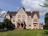
_Rittergut_Barockschlo%C3%9F.jpg)


Economy and Infrastructure
The B 6 , the Leipzig – Dresden railway and the Wurzen – Eilenburg railway, which is used for freight transport, run through the municipality .
There is a primary and a secondary school in Lossatal . The closest grammar school is in Wurzen. The community has had a modern sports center in the Falkenhain district since January 2017.
Sons and daughters of the previous towns
- Johann VI. von Saalhausen , bishop, made Wurzen the bishopric, born in Thammenhain
- Johann Christian Götze (1692–1749), librarian and theologian
- Gotthelf August Eichler (1821–1896), teacher and principal of the school for the deaf and dumb in Leipzig
- Hermann Pöge (1840–1894), entrepreneur
- Georg Wünning (* 1948), organ builder, born in Dornreichenbach
- Karl Czok (1949–2012), educator and politician (CDU)
- Reinhardt Hassa (* 1952), manager
- Helfried Schmidt (* 1957), publisher
- Holger Pohland (* 1963), athlete
- Tobias Bilz (* 1964 in Dornreichenbach), Evangelical Lutheran theologian , Regional Bishop of the Evangelical Lutheran Church of Saxony (since March 1, 2020)
Web links
Individual evidence
- ↑ Population of the Free State of Saxony by municipalities on December 31, 2019 ( help on this ).
- ↑ a b c d e f g State Statistical Office of the Free State of Saxony: Area changes
- ↑ a b c d e f g h municipalities 1994 and their changes since 01.01.1948 in the new federal states , Metzler-Poeschel publishing house, Stuttgart, 1995, ISBN 3-8246-0321-7 , publisher: Federal Statistical Office
- ^ A b Directory of communities and places for the Kingdom of Saxony, 1904, publisher: Statistical Bureau of the Royal Ministry of the Interior
- ^ The Sachsenbuch, Kommunal-Verlag Sachsen KG, Dresden, 1943
- ↑ a b Lists of the municipalities incorporated since May 1945 and evidence of the breakdown of the independent manor districts and state forest districts, 1952, publisher: Ministry of the Interior of the State of Saxony
- ↑ Results of the 2019 municipal council elections
- ↑ Final result of the mayoral election of the municipality of Lossatal ( page no longer available , search in web archives ) Info: The link was automatically marked as defective. Please check the link according to the instructions and then remove this notice. ( PDF file; 17 kB)
- ↑ Jörg Mantzsch : The coat of arms of the municipality of Lossatal, documentation on the approval process , deposited with the Leipzig district in 2014 (report: Saxon Central State Archive Dresden)
- ↑ Alexander Hoffmann: Communal coat of arms show . In: HEROLD, Association for Heraldry, Genealogy and Allied Sciences (Hrsg.): The Herold, quarterly for heraldry, genealogy and allied sciences . No. 3-4 / 2018 . Self-published, Berlin 2018.
- ↑ Inauguration of the new sports center in 2017
- ↑ Kai-Uwe Brandt: Lord Mayor opens exhibition in the St. Wenceslai town church - entirely under the sign of Wurzen Bishop Johann VI. von Salhausen, the exhibition “My Faith, My Power” has been in the Wenceslaikirche since Whit Monday. The mostly original exhibits can be seen until the beginning of October. Leipziger Volkszeitung , online portal. Retrieved May 27, 2018 .