Droßdorf (Groitzsch)
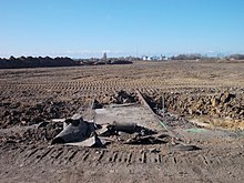
Droßdorf was a village northwest of Borna , which in the years 1982 and 1983, the lignite mining by open pit Schleenhain has fallen victim. His corridor now belongs to the village of Großstolpen in the city of Groitzsch in the Leipzig district ( Free State of Saxony ).
Geographical location and traffic
Droßdorf was in the Leipzig lowland bay between Borna in the southeast and Groitzsch in the northwest. It was on the B 176 and had a station on the Neukieritzsch – Pegau railway line, which is now closed . The devastated location is today in the north of the "Schleenhain" mining field of the United Schleenhain opencast mine, east of Pödelwitz and north of the newly traced B 176. Neukieritzsch is in the northeast .
history
Droßdorf was called around 1150 as "Drogisdorff". The local manor has been occupied since 1696. The first owner was the von Bose family , who sold the estate to the von Helldorf family at the beginning of the 18th century . Until 1856, Droßdorf was in the Electoral Saxon or Royal Saxon Office of Borna . From 1856 the place belonged to the Borna court office and from 1875 to the Borna district administration . On October 1, 1909, Droßdorf received a railway connection with the station of the same name on the Neukieritzsch – Pegau railway line .
1952 Droßdorf was assigned to the Borna district in the Leipzig district. On April 1, 1966, it was incorporated into Großstolpen . In the mining area of the Schleenhain opencast mine, which has been approaching from the south and later from the west since 1949 , Droßdorf was initially not planned due to its peripheral location on trunk road 176. Nevertheless, the place and the manor were demolished between 1982 and 1983. The 300 residents of Droßdorf were resettled. In the Groitzsch district of Großpriesligk , new homes were built on "Droßdorfer Straße" for the former Droßdorfer from 1981. Only the train station, a sheep farm and the brickworks a little to the north survived the devastation in Droßdorf, but they have since been demolished. The location of the Luther memorial, inaugurated in 1884, one kilometer east of Droßdorf, was also in the mining area of the Schleenhain opencast mine. For this reason, the 3.50 meter high obelisk with portraits of Katharina and Martin Luther was moved to the Neukieritzsch market in 1983 . Katharina von Bora , who later became Martin Luther's wife, was born in 1499 near Gut Lippendorf . Years later, her husband bought the Zöllsdorf estate in the Kieritzsch district as a retirement home for her , the location of which also had to give way to the opencast mine.
On June 1, 1997, travel on the Neukieritzsch – Pegau line was finally stopped. In 1998 all buildings on the site of the Droßdorf station were demolished. H. the U. a. of the signal box and the reception building from 1957. Parts of the former route have now been dredged over by the United Schleenhain opencast mine . The corridor of Droßdorf, which has not yet been dredged over, is intended for dismantling.
With the incorporation of Großstolpen into Groitzsch, the Droßdorf corridor has belonged to Groitzsch since January 1, 1996.
Places of remembrance
The coat of arms stone of the Droßdorf manor house, built in 1910, is the only remnant of the building that stands on a sandstone plinth in the corridor stone lapidarium on the Wiprechtsburg Groitzsch .
Web links
Individual evidence
- ↑ The Droßdorf Manor at www.sachsens-schlösser.de
- ^ Karlheinz Blaschke , Uwe Ulrich Jäschke : Kursächsischer Ämteratlas. Leipzig 2009, ISBN 978-3-937386-14-0 ; P. 62 f.
- ^ The Borna District Administration in the municipal directory 1900
- ↑ Droßdorf on gov.genealogy.net
- ^ Description of the Schleenhain opencast mine in a LMBV document
- ↑ Großpriesligk on www.reitwanderfuehrer.de
- ↑ Droßdorf in a geocaching portal including an old map
- ^ Description of the Peres opencast mine in a LMBV document; P. 31 and 34
- ^ The Droßdorf stop at www.sachsenschiene.net , accessed on July 19, 2016.
- ↑ The Flursteinlapidarium on www.reitwanderfuehrer.de
Coordinates: 51 ° 8 ′ 52.2 " N , 12 ° 22 ′ 3.8" E


