
Magdeborn


Magdeborn was a village south of Leipzig . It was in the district Leipzig-Land , Leipzig district . It was created in its last form in 1934 through the merger of seven villages and was named after the Magdeborn square, which only consists of a church, parsonage and school. The name Magdeborn comes from a fort Medeburu (first mentioned in 969). From an ecclesiastical perspective, the villages belonged to the parish of Magdeborn. Around 1940 the place was expanded to include a large settlement for the employees of the lignite industry emerging in Espenhain . Between 1977 and 1980 Magdeborn had to give way to lignite mining after all of the 3200 inhabitants had been resettled since the late 1960s. This is the largest number of residents in the southern Leipzig area who had to leave their community because of the lignite. From August 1, 1980, the area of the place belonged to the municipality of Störmthal , which has been incorporated into Großpösna since 1996 . A large part of the area of the former Magdeborn is now covered by Lake Störmthal .
The districts


- Göhren - originated as a small village in the north of Magdeborn, expanded to the northeast at the beginning of the 20th century (Neu-Göhren), estate with brewery and inn, brewery settlement on the grounds of the estate and brewery
- Sestewitz - a manor settlement in the northwest of Magdeborn that was built around an outbuilding of the manor Crostewitz
- Dechwitz - predominantly rural settlement developed from a round hamlet in the west of Magdeborn
- Kötzschwitz - individually standing manor, later, among other things, municipal office
- Gruna - emerged as a round village in the south of Magdeborn
- Göltzschen - Gassendorf in the southeast of Magdeborn with an almost purely rural character
- Tanzberg - Häuslerzeile near the Magdeborn church
- Settlement - the largest district of Magdeborn, built around 1940 as a miners' settlement, northeast of Tanzberg
The name development of the districts from their first mention:
- Göhren - (1322) Gören, Goren, Gorin, Jorin, Joren, Goren, Gehren, Göhren b. Leipzig
- Sestewitz - (1350) Sexwicz, Seßewicz, Sessewitz, Seschewitz, Sesswitz, Sesserwitz, Sestewitz
- Dechwitz - (1240) Techanuiz, Dechnewicz, Techinwicz, Techewicz, Tegewicz, Teichwitz, Dechwitz
- Kötzschwitz - (1442) Kotzscherwitz, Kotczewicz, Kotschwitz, Koetzschitz, Kötzschwitz
- Gruna - (1456) Grunaw, Grunaw, Grunau, Gruna, Grune, Gruhna (Gruna)
- Göltzschen - (1335) Kollynschen, Golycschen, Gollecschen, Goliczschenn, Koltzen, Goltschen, Gölczschenn, Göltzschen
- Tanzberg - (1463) the Tantzberg, Tanzberg
- Magdeborn - (969) Medeburu, Medeburun, Meydebur, Meydeburne, Meydeborne, Meideborn, Magdeborn
The initial name of Magdeborn goes back to the Sorbian word Med = honey. Only later ignorance of the Sorbian language or a certain intention to Germanize lead to the interpretation Maid, Magd and Born.
The population development of the districts and Magdeborns:
| 1834 | 1871 | 1890 | 1910 | 1925 | |
|---|---|---|---|---|---|
| Goehren | 196 | 225 | 240 | 523 | 550 |
| Sestewitz | 116 | 110 | 142 | 134 | 147 |
| Dechwitz | 91 | 108 | 75 | 128 | 129 |
| Kötzschwitz | 19th | 10 | |||
| Gruna | 175 | 180 | 190 | 187 | 197 |
| Göltzschen | 158 | 198 | 199 | 161 | 145 |
| Tanzberg | 90 | 123 | 91 | 177 | 182 |
| together | 845 | 954 | 937 | 1310 | 1350 |
- ↑ Kötzschwitz counted from around 1900 at Tanzberg.
| 1933 | 1939 | 1946 | 1950 | 1964 | 1977 | |
|---|---|---|---|---|---|---|
| Magdeborn | 1474 | 2002 | 3939 | 3992 | 3126 | approx. 3200 |
geography
location
Magdeborn was about 12 km south-southeast of Leipzig in or on the wide valley of the Gösel , a tributary of the Pleiße, which ran to the northwest . The north-eastern edge of the valley rose 20 to 30 meters above the river level, which resulted in a varied landscape and beautiful toboggan runs in winter (Krankenberg, Kaiserberg). The Gösel itself flowed through meadows, on the edges of which the districts lay.
The neighboring towns of Magdeborn were clockwise from the north: Auenhain (to Wachau ), Güldengossa (now to Großpösna ), Störmthal (with Rödgen , now to Großpösna), Dreiskau , Espenhain , Geschwitz (to Rötha , excavated in 1951/52), turnips ( Dredged in 1955/57), Zehmen (dredged in 1957/58) and Cröbern (dredged in 1982).
In the current post-mining design of the landscape, the areas of the former districts of Magdeborn are at the following locations. Tanzberg with the settlement, Kötzschwitz, Göltzschen and the eastern fields of Magdeborn are flooded by Lake Störmthal . Göhren and Sestewitz are located under the storage area of the central landfill Cröbern. An island east of it now bears the name "Göhrener Insel". The operational buildings of the Cröbern central landfill are located above the Dechwitz area. Gruna was not dredged over; this area is now called the Magdeborn Peninsula. A chestnut planted in Gruna in 1907 survived the neighboring open-cast mine and is now known as the “survival chestnut”.
Waters
The Gösel reached by Dreiskau and Muckern coming to the local area Magdeborn between Gruna and Göltzschen flowed between dance and mountain Kötzschwitz, and between Göhren and Dechwitz further and left the hall in Magdeborner Sestewitz. It was heavily contaminated by waste water from the carbochemistry from the Espenhain lignite mine from the 1940s onwards.
Coming from the east, the Schlumper flowed at Gruna . This originated in Oberholz and flowed past Störmthal and Rödgen in a meadow valley towards Göltzschen, which it passed to the north.
Magdeborn once owned five ponds in Göhren, Sestewitz, Dechwitz, Gruna and Göltzschen, of which only the last two still existed in the end. The Sestewitz pond was fed by the Mühlgraben branching off in Dechwitz, but was drained when the mill was switched to electric drive at the end of the Second World War and used as an allotment area.
traffic
Magdeborn was on or near the medieval Via Imperii , which led from the Hanseatic cities on the Baltic Sea via Leipzig and Nuremberg to Venice. In the south of Leipzig this ran via Markkleeberg and Borna to Altenburg . At first it only brushed the Magdeborn corridor, as it ran from Cröbern past Zehmen and Rüben to Rötha . By continuing to use it as a Poststrasse, the flood-prone Pleißetal was avoided and driven from Cröbern via Sestewitz, Dechwitz, Gruna and Espenhain on the so-called Hohen Poststrasse to Borna. Gruna even owned a post office.
In the first half of the 19th century, the Göseltal was also abandoned, and the connection to Magdeborn was on high ground via Probstheida and Wachau. This street reached Magdeborn in Göhren. Numerous single-family houses (Neu-Göhren) were built on it. The Göseltal was crossed on a dam to Dechwitz. This arch over Dechwitz was straightened in the 1930s between Tanzberg and Gruna. This resulted in the course of the connection now known as Reichsstrasse , later trunk road 95 .
There were bus connections to Leipzig and Borna via the F 95, with stops at the northern entrance to the town (Bergstrasse), in Magdeborn-Mitte and Gruna. These bus routes were supplemented by a lively factory traffic to the Espenhain lignite plant. Magdeborn did not have a railway connection.
history


The place Magdeborn probably originated in the 7th century as a Slavic settlement. In 969, Emperor Otto I left the Medeburu fort in Gau Chutizi to the Merseburg bishop Boso (first mentioned). Magdeborn thus became a center in the spread of the Christian faith, but also a certain economic center for the surrounding villages (delivery of tithes ). The bishops of Merseburg were feudal lords of Magdeborn for several centuries , and the owners of the Kötzschwitz manor were enfeoffed with Magdeborn. Nickel and Hans von Zehmen acquired the manor Kötschwitz with Magdeborn from the Bishop of Merseburg in 1420. In 1435 Hans, Conrad, Thyme von Zehmen are named in the Merseburg general fiefdom of the manor Kötschwitz with Magdeborn. In 1654 or 1655/1663 Georg Oswald von Zehmen and his descendants sold the estate to Lieutenant Captain Christian v. Seidel.
When the so-called Leipzig division of Saxony between the Wettin brothers Albrecht and Ernst in 1485, the diocese of Merseburg and Magdeborn became part of Meissen . In 1539 the Reformation movement reached Magdeborn.
In 1682 there was a great plague epidemic in the villages around Magdeborn, especially in Dechwitz . In 1756 the church burned down by lightning and could not be rebuilt until 1784. In the same century the pastor of Magdeborn experienced several suspensions because of "unauthorized copulation", which in the description of the church history of Magdeborn in the middle of the 19th century led to comparisons with the events in Gretna Green .
In the Battle of the Nations near Leipzig in 1813, Magdeborn was the allies' deployment area before the fighting on October 14th and 16th, whereby the civilian population had to bear the burden of supplying the troops. The King of Prussia Friedrich Wilhelm III. was quartered in Gruna. He rode every day to the briefing in the castle in Rötha . The Russian Tsar Alexander I and the Austrian Emperor Franz I lived here. These three monarchs watched the fighting near Güldengossa on October 16 from the Wachtberg north of Göhren. Prince Eugene of Württemberg had spent the night before in Dechwitz. A simple memorial on the Wachtberg later commemorated the events. It was moved to Wachau near the church ruins in 1982 . On March 8, 1878, the Magdeborn men's choir was founded in the Bergschänke zum Tanzberg. In 1912, funds from Ferdinand Jost's inheritance were used to convert the church to its final form (architect Paul Lange ), and the rectory was rebuilt.
Tanzberg with the Magdeborn church and the Kötzschwitz estate, like the villages of Dechwitz, Göltzschen, Gruna, Göhren and the Sestewitz suburb, were in the electoral and royal Saxon district offices of Leipzig until 1856 . From 1856 the places belonged to the Rötha court office and from 1875 to the Leipzig district administration . In 1929 Sestewitz was incorporated into Göhren.
In 1934 the founding of all seven districts (Magdeborn, Tanzberg, Kötzschwitz, Dechwitz, Göltzschen, Gruna, Göhren with Sestewitz) took place in Magdeborn. In the following years, a large housing estate with two- and three-story houses was built on the hillside in the northeastern connection to Tanzberg as well as further apartment buildings on Bergstrasse and on the brewery in Göhren for the employees of the emerging lignite plant Espenhain. The village character of Magdeborn took a back seat. On April 22, 1945, American troops coming from the south occupied Magdeborn and were relieved by the Russian occupation forces in mid-June.
- Historical postcards
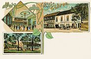
Gasthof Goehren

Goehren

Gruna

Tanzberg


In the course of the land reform in 1946, the Kötzschwitz estate, the Sestewitz Vorwerk and the areas of the former Göhren brewery were expropriated and 26 new farmer positions were set up. After the war, the population grew again due to the influx of expellees from the former German eastern regions. At the end of the 1950s, collectivization began in agriculture with the LPG "Göseltal" in Göltzschen. In 1960 Magdeborn was “fully cooperative”, and in 1963 seven LPGs were formed into a single village - “United Magdeborn”.
At the end of the 1960s, the resettlement of the residents of the Magdeborn districts began, which were now intended to be demolished and dredged over by the Espenhain open-cast lignite mine . They mostly received apartments in the new prefabricated housing estates in Leipzig, such as Grünau , Mockau or Schönefeld , but also in Borna . Former homeowners looked for new properties with the help of their moderate compensation, mostly in the vicinity of Leipzig. Some residents moved away from the area entirely. The resettlement and devastation of the districts took place at the following times:
- 1963: Gruna and Kötzschwitz
- 1965: Dechwitz
- 1967/68: Göhren with Sestewitz
- 1977–1980: Magdeborn, Tanzberg, Göltzschen
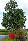
“Survival chestnut” Gruna,
the only surviving tree in Magdeborn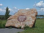
Memorial stone for the former municipality of Magdeborn on the south bank of Lake Störmthal


Before it was demolished, the Magdeborn Church was deedicated on September 3, 1978. Many of their furnishings are now used in other churches, such as B. the altar in the Luther Church Chemnitz-Harthau , the organ in the Martin Luther Church Markkleeberg , the pulpit in the Resurrection Church Leipzig-Möckern and three bells in the Pauluskirche Leipzig-Grünau .
From August 1, 1980, the area of the former municipality of Magdeborn belonged to Störmthal, which in turn was incorporated into Großpösna in 1996. 1993–1996 the open-cast mining operation of the Espenhain mine was gradually discontinued. The last coal train drove on June 27, 1996, and the overburden conveyor bridge was blown up on May 6, 1997. Since January 1, 2001, the remaining hole Espenhain has been filled with water to the Störmthaler See , the official start of flooding with swamp water from still active opencast mines was on September 13, 2003. In 2012, the flooding was over.
School system
Until the 17th century, the (mainly religious) instruction of children was taken over by the church in the person of the so-called Kirchner. Philip Widemann is mentioned as the first schoolmaster in Magdeborn in 1646. From 1729 to 1840, the Magdeborn schoolmaster's position was in the hands of the Winkler family for 111 years, with grandfather, father and son teaching the children of the Magdeborn parish one after the other (and partly at the same time as a “substitute”).
From 1841 two schoolmasters were required because of the increase in the number of children (180). In 1896 a new school was built with two classrooms, in 1912 and 1933/34 this was expanded by two classrooms each. In 1945, apartments above the school rooms were converted into classrooms. Some of the lessons were also taught in makeshift rooms outside the school building. In 1949 the construction of a 4-room school building began in the school yard. In 1959 the 8-class elementary school became the 10-class general polytechnic high school (POS). In 1965/66 another new building was built with 4 classrooms, teachers' rooms, gym and toilets. The space now comprised 15 classrooms, a chemistry room, 2 workrooms and a gym for around 550 students in 20 classes with 28 teachers.
Trade and commerce (selection)
Trade and commerce in Magdeborn were mainly characterized by retail and craft. It was mainly about the supply of the local population. Only about the last five positions on the following list had significance beyond the place.
- Inns:
- Schützenhof (Gruna) , in GDR times: Magdeborner Hof
- To the Schießgraben (Dechwitz) , in GDR times: Sächsischer Hof
- Gasthof Magdeborn (Göhren) , formerly affiliated brewery
- Bergschänke (Tanzberg)
- Gasthof Kersten (Gruna) , operated in addition to a shoemaker's shop
- At Hasch (Sestewitz) , during the GDR era: Dormitory for the Espenhain plant
- Bakers: Köhre (Gruna) , Däbritz, Wilke (Göhren) , Hänseroth (settlement)
- Fleischer: Kind (Göhren) , Schramm (Tanzberg) , Winter (settlement)
- Groceries: Mühlberg & Möckel (Göhren) (also building materials), consumption (settlement) , Lemmel (Tanzberg)
- Fish trade: Wilke (Göhren)
- Books and stationery: Haupt (Göhren)
- Textiles: Paschy (Dechwitz)
- Hairdressers: Lange (Göhren) , Hädrich (Göhren)
- Shoemaker: Kersten (Gruna)
- Plumber: Freudenberg (Göhren)
- Forge: Günsel (Göltzschen) , Deutrich (Göhren) , Strasbourg (Gruna)
- Construction business: Reiher (Göhren)
- Carpenter: Richter (Gruna) , Süßkind (Göltzschen)
- Roofing contractor: Misslitz (Kötzschwitz)
- Nursery: Dippe (Tanzberg) , Pietzsch (Göhren) , Krenek (Dechwitz)
- Coal trade: Brause (Göhren)
- Car repair u. Ä .: Chemnitz (Gruna) , Irmscher (Göhren)
- Saddlery: Voigt (Gruna) , Teuchert (Göhren)
- Laundry: Krah (Göhren) , Jahn (Gruna) , Berger (Sestewitz)
- Sweet cider press: Klaus (Göhren)
- Dairy: ham (Gruna)
- Mill: Gösel-Mühle Kaiser (Sestewitz)
Street directory
The list contains the streets of Magdeborn at the time the place was given up.
- At the Berggarten (Göhren)
- Am Tanzberg (Tanzberg)
- At the pond (Sestewitz)
- August-Bebel-Strasse (settlement)
- Barbara-Eck (settlement)
- Bornaische Strasse (Kötzschwitz, Gruna)
- Borngasse (Sestewitz)
- Cröberner Strasse (Göhren)
- Dechwitzer Strasse (Sestewitz, Dechwitz)
- Dorfstrasse (Dechwitz)
- Dreiskauer Strasse (Göltzschen, Tanzberg)
- Ernst-Thälmann-Strasse (Tanzberg, settlement)
- Ferdinand-Jost-Strasse (settlement)
- Franz-Mehring-Strasse (settlement)
- Friedrich-Ebert-Siedlung (settlement)
- Friedrich-Engels-Strasse (Göhren)
- Gartenstrasse (settlement)
- Göltzschener Strasse (Göltzschen)
- Güldengossaer Strasse (Göhren)
- Heinrich-Heine-Strasse (settlement)
- Karl-Liebknecht-Strasse (Göhren)
- Karl-Marx-Platz (settlement)
- Käthe-Kollwitz-Strasse (Göhren)
- Kirchgasse (settlement)
- Kirchstrasse (settlement)
- Long way (Göltzschen)
- Leipziger Strasse (F95) (Göhren, Gruna)
- Rosa-Luxemburg-Strasse (settlement)
- Rödgener Strasse (Göltzschen)
- Rudolf-Breitscheid-Strasse (settlement)
- Sestewitzer Strasse (Sestewitz)
- Störmthaler Weg (settlement)
- Wiesenstrasse (Dechwitz)
Follow-up time
Vineta on the Störmthal lake

The Vineta (2014)

Ferry to Vineta


The memory of Magdeborn, which sank in Lake Störmthal after its demolition, is kept alive in a special way. About one kilometer east of the old location of the Magdeborn Church, an installation (the so-called “Seekirche”) was anchored on the lake according to a project by Ute Hartwig-Schulz as part of the project Art Instead of Coal , which as an artistic interpretation of the former Magdeborn Church recognize is. ( → Position ) On a floating platform of approx. 15 x 20 meters there is a building of approx. 7 x 14 meters, crowned by a tower-like, illuminated structure approx. 15 meters high. It was built based on the passive house energy standard in wood construction including a photovoltaic system and heat recovery, so that the art object is operated almost energy self-sufficient.
The topping-out ceremony for the building took place on December 21, 2009. The floating on the anchoring point took place on November 24, 2010. On Sundays and public holidays in the summer half year from April to October, the Vineta ferry crosses the Magdeborn peninsula to the Seekirche.
The property is also available for events such as specialist lectures, readings and concerts. The Vineta is operated as an event location by the Krystallpalast Varieté Leipzig. The Großpösna registry office uses the Vineta as a wedding venue.
Lagovida


From 2013 to 2014 the holiday resort Lagovida was built on the Gruna Bay on the south bank of the Störmthaler See near the former Magdeborn district of Gruna . It consists of a hotel with a restaurant and holiday homes, of which the so-called harbor houses protrude over the water and the dune houses have direct access to the beach. A pleasure boat harbor is protected by a pier. A mobile home parking lot as well as a bathing and surfing beach complete the complex. The bronze statue Bella Gruna, created by Mölbis artist Jürgen Raiber , stands on a boulder at the lookout point in memory of the Mageborn district.
literature
- Saxony's church gallery . Volume: Inspections Leipzig and Grimma; Hermann Schmidt, Dresden 1837–1845
- 1000 years of Magdeborn , commemorative publication 1968
- In the Pleisse and Göselland between Markkleeberg, Rötha and Kitzscher - published by PRO LEIPZIG eV, Leipzig 1999, ISBN 3-9806474-1-2
- Authors' group Magdeborner Heimatfreunde (Ed.): Magdeborn - Verlorene Heimat , Südraum-Verlag Borna 2012, ISBN 978-3-937287-39-3
- Stefan Hänsel: Local family book Magdeborn 1673-1766. Berlin: epub 2014, ISBN 978-3-8442-9170-4 , 1756 families
- Magdeborn . In: August Schumann : Complete State, Post and Newspaper Lexicon of Saxony. 6th volume. Schumann, Zwickau 1819, p. 106 f.
- Magdeborn . In: August Schumann : Complete State, Post and Newspaper Lexicon of Saxony. 18th volume. Schumann, Zwickau 1833, p. 20.
- GA Poenicke (Ed.): Album of the manors and castles in the Kingdom of Saxony based on nature, newly recorded by F. Heise, Architect. I. Section: Leipziger Kreis. Leipzig 1860, Rittergut Kötzschwitz, pp. 179–180 (digitized)
Web links
- Private website about Magdeborn
- VINETA on the Störmthaler See - a unique event location in Europe. In: Website Großpösna. Retrieved April 13, 2020 .
- The realization of the Vineta project
- Lagovida website
- Magdeborn in the Digital Historical Directory of Saxony
Individual evidence
- ^ A b Digital Historical Directory of Saxony
- ↑ Sachsens Kirchen-Galerie, Dresden 1837–1845 Volume: Inspectionen Leipzig and Grimma, p. 147
- ^ Karlheinz Blaschke , Uwe Ulrich Jäschke : Kursächsischer Ämteratlas. Leipzig 2009, ISBN 978-3-937386-14-0 ; P. 60 f.
- ↑ The Amtshauptmannschaft Leipzig in the municipal register 1900
- ↑ http://www.kunst-statt-kohle.de/ Page of the project art instead of coal by Ute Hartwig-Schulz.
- ↑ http://www.vineta-stoermthal.de/ Page of the Vineta
Coordinates: 51 ° 14 ′ 15 ″ N , 12 ° 26 ′ 25 ″ E