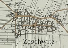
Zeschwitz
Zeschwitz was a village south of Leipzig that was the first to fall victim to central German lignite mining as a whole. Its corridor was incorporated into Böhlen in 1942 .
location
Zeschwitz was about two kilometers southeast of Zwenkau and just as far northeast of Böhlen and thus on the flat ridge between the valleys of the White Elster and the Pleiße . There was a road connection to both places and to Stöhna . The large forest area of the Harth began about 700 meters north of Zeschwitz .
In today's area, after the recultivation of the mining areas, the Zeschwitz square is to be paved about 500 meters southeast of the bridges on Bundesstrasse 2 in front of the Zwenkau industrial park (coming from Leipzig).
history
Like most places in the area, Zeschwitz was a Slavic foundation that must have existed long before it was first mentioned in 1431 as Scheschewitz. Gurlitt concludes from the characteristics of the construction of the Zeschwitzer church that it cannot be ruled out before 1300. The two church bells were labeled 1500. The names of the pastors in Zeschwitz are known from 1599, those of the school teachers from 1730. In 1825 the church tower was given a new hood, in 1829 the interior of the church was renovated, and in 1834 Urban Kreutzbach from Borna built a new organ. Zeschwitz was its own parish until 1924, when it became a branch church of Böhlen.
Zeschwitz did not own a manor, so the jurisdiction was partially exercised by neighboring landlords. From 1764 it was an administrative village of the Electorate of Saxony , i.e. directly subordinated to the lordly office of Pegau . However, it is believed that the largest farm in the village once belonged to the von Zweimen family . However, like the neighboring forest Die Harth, part of the village belonged to the Hochstift-Merseburg office of Zwenkau as an exclave until 1815 , which later became part of the office of Lützen and had been under Electoral Saxon sovereignty since 1561. With this this part belonged between 1656/57 and 1738 to the secondary education principality of Saxony-Merseburg . As a result of the resolutions of the Congress of Vienna , the western part of the Lützen district became part of Prussia in 1815. The part of Zeschwitz that remained with the eastern part of the Lützen office in the Kingdom of Saxony was initially assigned to the Leipzig district office in 1815 , but was later combined with the Pegau office part. Zeschwitz came in 1856 to the court office in Zwenkau and in 1875 to the Leipzig administration . The population of Zeschwitz was 229 in 1834 and rose to around 400 in the 1920s and 1930s.
Until around 1940, Zeschwitz was a popular hiking destination for the people of Leipzig from Gaschwitz train station through the Harth. That is why the well-filled beer gardens of the inns in Zeschwitz were often depicted on old postcards.
In 1921, the joint stock company Sächsische Werke (ASW) in Böhlen began to work on an open- cast lignite mine , from which the first coal was extracted in 1924. Zeschwitz was in the immediate catchment area. That is why ASW had already started to buy up farms and houses in Zeschwitz in the mid-1920s. At the beginning of the 1940s, the excavators from the Zwenkau opencast mine were located near the houses in Zeschwitz. On May 1, 1943, the evacuation of the place was completed. For the first time, an entire village was demolished for the extraction of lignite. Nothing on the recultivated former mining site reminds of the village of Zeschwitz.
Web links
Individual evidence
- ↑ a b c Digital Historical Directory of Saxony
- ↑ Cornelius Gurlitt : Zeschwitz. In: Descriptive representation of the older architectural and art monuments of the Kingdom of Saxony. 16. Issue: Amtshauptmannschaft Leipzig (Leipzig Land) . CC Meinhold, Dresden 1894, p. 141.
- ↑ a b c d Saxony's church gallery . Volume: Inspections Borna and Pegau , Dresden 1837–1845
- ^ Karlheinz Blaschke , Uwe Ulrich Jäschke : Kursächsischer Ämteratlas , Leipzig 2009, ISBN 978-3-937386-14-0 , p. 62 f.
- ^ Karlheinz Blaschke , Uwe Ulrich Jäschke : Kursächsischer Ämteratlas , Leipzig 2009, ISBN 978-3-937386-14-0 , p. 84 f.
- ↑ The Amtshauptmannschaft Leipzig in the municipal register 1900
- ^ Mining history on the website of the city of Zwenkau
Coordinates: 51 ° 12 ′ 32.8 " N , 12 ° 21 ′ 27.7" E


