Zaderlehde
|
Zaderlehde
Rural community of Mohlsdorf-Teichwolframsdorf
Coordinates: 50 ° 43 ′ 28 ″ N , 12 ° 13 ′ 30 ″ E
|
|
|---|---|
| Height : | 380 m above sea level NN |
| Postal code : | 07987 |
| Area code : | 03661 |
|
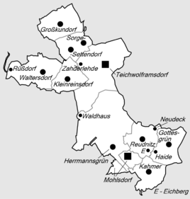
Location of Zaderlehde in the rural community of Mohlsdorf-Teichwolframsdorf
|
|
|
View of part of the local area
|
|
Zaderlehde (unofficially more rarely also Zahderlehde ) is a locality of Teichwolframsdorf , a district of the rural community Mohlsdorf-Teichwolframsdorf in the southeast Thuringian slate mountains and belongs to the district of Greiz in Thuringia .
location
The location of Zaderlehde is on the eastern slope of the "Obere Felder" elevation ( 410.1 m above sea level ) on the connecting road from Sorge-Settendorf to Teichwolframsdorf . The Kleinreinsdorf district is barely 500 m to the west . State road 2338 passes about 400 m north of the outskirts of Zaderlehde and is designated as a section of the Thüringenweg tourism project . About 500 meters (as the crow flies) to the northeast is the single farm "Fichtelburg", which also belongs to Teichwolframsdorf.
history
A Zader family that has been traceable since the 17th century is said to have acquired the fallow field on a mountain slope. Zahderlehde was first mentioned in a document in 1800, the first known spelling was "Zoterlede", then in 1810 "Zoterleite". The path leading to the then state border of Saxony-Weimar-Eisenach was used in the following years for the settlement of some farms and later preferred by craftsmen and workers who had simple houses built there and looked for their livelihood by working from home, as seasonal workers in the Worked in agriculture or found work in the Teichwolframsdorfer weaving mills and spinning mills.
literature
- The northern Vogtland around Greiz . A geographical inventory in the area of Greiz, Weida, Berga, Triebes, Hohenleuben, Elsterberg, Mylau and Netzschkau. In: Leibniz Institute for Regional Geography (Ed.): Landscapes in Germany . tape 68 . Böhlau Verlag, Leipzig 2006, ISBN 3-412-09003-4 , Teichwolframsdorf with Zahderlehde, Greiz district, p. 201-204 .
Web links
Individual evidence
- ↑ Reinhold, F .: A new interpretation of the field name Zahderlehde in Teichwolframsdorf / Greiz district . In: Yearbook of the Hohenleuben-Reichenfels Museum (MHR) . tape 23 , 1987, pp. 87 .
- ^ Wolfgang Kahl : First mention of Thuringian towns and villages. A manual. Rockstuhl Verlag, Bad Langensalza, 2010, ISBN 978-3-86777-202-0 , p. 322


