God green
|
God green
Rural community of Mohlsdorf-Teichwolframsdorf
Coordinates: 50 ° 40 ′ 21 ″ N , 12 ° 18 ′ 9 ″ E
|
|
|---|---|
| Height : | 363 m above sea level NN |
| Residents : | 260 |
| Incorporation : | March 8, 1994 |
| Incorporated into: | Mohlsdorf |
| Postal code : | 07987 |
| Area code : | 03661 |
|
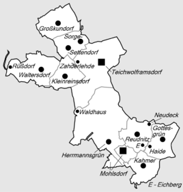
Location of Gottesgrün in the rural community of Mohlsdorf-Teichwolframsdorf
|
|
|
In the town
|
|
Gottesgrün is a district of the rural community Mohlsdorf-Teichwolframsdorf in the district of Greiz in Thuringia .
location
Gottesgrün is east of Mohlsdorf. The district is located on the border with Saxony near the village of Reuth . To the north of the village, the Werzeit-Greizer forest extends . The corridor of the street village Gottesgrün still belongs to the Thuringian Slate Mountains ( East Thuringian-Vogtland plateau ) in the Thuringian or Russian part of the historical Vogtland . The County Road 509 passes through the district. The Gottesgrüner Aubach flows through the village and merges in Mohlsdorf with the Reudnitzer Aubach to form the Aubach , a tributary of the White Elster .
history
The first documentary mention of the place was on May 23, 1507. The Evangelical Lutheran parish of Gottesgrün exists in the agricultural town.
As of 2012, 260 people live in the place.
Web links
Individual evidence
- ^ Wolfgang Kahl : First mention of Thuringian towns and villages. A manual. Rockstuhl Verlag, Bad Langensalza, 2010, ISBN 978-3-86777-202-0 , p. 96
- ^ Church district Greiz: Evang.-Luth. Church parish of Gottesgrün. Retrieved June 3, 2017 .

