
Aubach (White Magpie)
|
Aubach Gräßlitz (lower reaches) |
||
 The Aubach in Greiz-Aubachtal near the ice rink |
||
| Data | ||
| location | Thuringia , Germany | |
| River system | Elbe | |
| Drain over | White Elster → Saale → Elbe → North Sea | |
| origin | Union of Gottesgrüner Aubach and Reudnitzer Aubach in Mohlsdorf 50 ° 40 ′ 11 ″ N , 12 ° 15 ′ 59 ″ E |
|
| Source height | 317 m above sea level NN | |
| muzzle | in Greiz in the White Elster Coordinates: 50 ° 39 ′ 18 ″ N , 12 ° 12 ′ 0 ″ E 50 ° 39 ′ 18 ″ N , 12 ° 12 ′ 0 ″ E |
|
| Mouth height | 261 m above sea level NN | |
| Height difference | 56 m | |
| Bottom slope | 9.3 ‰ | |
| length | 6 km | |
| Left tributaries | Schönfelder Bach | |
| Right tributaries | Marksbach, Fersenbach, Bäumde | |
| Reservoirs flowed through | Mohlsdorf reservoir | |
| Medium-sized cities | Greiz | |
| Communities | Mohlsdorf-Teichwolframsdorf | |
The Aubach , called Gräßlitz in the lower reaches , is a right tributary of the White Elster in Thuringia about 6 km long (with a left source stream 12 km) . The source streams arise in Saxony.
course
The Aubach is created in Mohlsdorf by the union of two source streams, both of which are also called Aubach.
The six-kilometer-long source brook on the left, also known as God's green Aubach, rises near the town of Brunn at around 410 m above sea level. NHN. It initially flows north and is dammed into a washing pond in Reuth . Below this pond it crosses the border between Saxony and Thuringia, turns west and flows through the village of Gottesgrün . Mohlsdorf is reached along the road to Kahmer .
The right source stream, also called Reudnitzer Aubach, is about four kilometers long. It rises in the Wer Duration-Greizer Forest on Saxon territory east of the Thuringian hamlet of Neudeck at about 400 m above sea level. NHN and flows in a westerly direction via Reudnitz to Mohlsdorf.
Both streams meet in Mohlsdorf at the junction of the road to Kahmer from the Greiz - Werdau road . The Aubach passes under the latter shortly afterwards and flows around the Mohlsdorf sports field. In this area the Marksbach flows from the right, which for several decades flowed into the Reudnitzer Aubach above the junction of the two source brooks through artificial relocation.
It continues in a westerly direction until the Aubach is dammed about two kilometers below the village to the Mohlsdorf reservoir, also known as the Aubachtaler reservoir. This was built in the mid-1950s for the purpose of flood protection and for the supply of service water.
700 meters downstream of the reservoir is also fed by the Aubach Hirsch pond happened and the Greizer district Aubachtal is reached. Here the Schönfelder Bach flows from the left and the Fersenbach from the right.
This district is traversed approximately as far as Genossenschaftstraße, then the core town of Greiz begins. The creek then flows underground for a length of about 100 m, but comes to light again in the area of Brauereistraße. Shortly afterwards, it finally disappears underground and is called Gräßlitz from here on. It flows under the former textile finishing plant , crosses August-Bebel-Straße ( B 94 ) at 700 meters and, after Dr.-Rathenau-Platz, flows into the White Elster directly under the castle bridge.
history
In the past, the Gräßlitz flowed openly in Greiz in the middle of today's August-Bebel-Straße, then over today's Dr.-Rathenau-Platz, through today's Thomasstraße, over today's Puschkinplatz and through the Baderei and ended in the area of today's Sparkasse building.
In order to gain space for road traffic and to protect the city center from flooding, it was relocated from today's Dr.-Rathenau-Platz through the former kitchen garden of the Lower Castle in 1903 . When the old town bypass was built in the early 1990s, the course was slightly relocated.
In 1938 the overbuilding of the stream in today's August-Bebel-Straße began. The first construction phase between today's Friedrich-Naumann-Straße and Grünrathstraße was completed in May 1939, after which work came to a standstill due to the war. The project was only completed in 1963.
Until the construction of the Mohlsdorf sports field in the early 1950s, the Aubach accompanied Greizer Straße to the end of the town and only moved away from it there. The "Untere Mühle", which is no longer on the creek, testifies to this today.
In the mid-1980s, the creek bed in Greiz-Aubachtal was relocated to a length of around 300 m in connection with the extension of Feldschlößchenstrasse below the deer pond.
In prehistoric times the Gräßlitz - with today's location information - crossed the Marienstraße coming from the Thomasstraße and ended in the area of the Parksee. When the slope to the White Elster was broken through in the area of the Baderei, the Greizer Schlossberg emerged as a breakthrough mountain .
Mills
There used to be a few mills on the Aubach, which are only partially preserved today. The first two mentioned were not at the united Aubach, but at the source streams in Mohlsdorf, but should be mentioned anyway.
The Obermühle or Fuchsmühle was about 400 m above the junction of the source streams on the Gottesgrüner Aubach . Apart from a remnant building used as a garage, nothing remains of this. The Dittmar dye works was later built on the site, and today it is used by the "Weber Business Park".
The Mittelmühle is located about 70 m above the confluence between the two streams . One of the buildings housed the Mohlsdorf post office for years, today the remaining houses are used for residential purposes. The area around the mill pond was designed like a park at the beginning of the 21st century.
The Untere Mühle or Wolffsche Mühle can also be found in Mohlsdorf, on the right of the road to Greiz . The property is no longer on the creek today, the mill technology was removed in GDR times.
The Hirschmühle is located in Greiz-Aubachtal, on Werlänge Street . Until the second half of the 19th century, their buildings were the only ones in the Aubach valley between Mohlsdorf and Greiz. After the Second World War it served as a vocational school for the Greiz textile industry, and later for a long time as a day nursery. Today the restored mill buildings are used as apartments.
The Neumühle was located in the area of the new sports hall in Greiz-Aubachtal. The site was later used by the "Gentsch und Pertzel" weaving mill, Greika 's V / 2 factory during the GDR era . After this was shut down in the 1990s and demolished at the beginning of the 21st century, the area lay fallow until the construction of the sports hall in 2014.
The town mill in Greiz was not far from the confluence of the Gräßlitz into the White Elster until 1903, but was driven by the water of the latter and is therefore not considered here.
Flood
Again and again, floods from the Aubach and the Gräßlitz caused floods and considerable property damage, especially in the urban area of Greiz.
The worst flood disaster occurred on 3rd / 4th. June 1889. The water level marks of these days were never reached by any earlier or later flood. In the Aubachtal factories and in the city center of Greiz (today: August-Bebel-Straße, Dr.-Rathenau-Platz, Thomasstraße, Puschkinplatz, Baderei) the water caused great devastation.
In the summer of 1984, within a few days, the Werführung Strasse, the swimming pool and the Oßwaldstrasse in Greiz-Aubachtal were flooded twice. The cause was a broken dam in a pond.
During the flood in 2013 , streets, properties and the sports field in Mohlsdorf were affected. In Greiz-Aubachtal, the Hirschmühle, Werlänge Strasse, the swimming pool, the Käte Duncker kindergarten and Oßwaldstrasse sank into the water. The ice rink could be protected from damage by sandbag barriers.
Water quality
In the 20th century, the Aubach was heavily polluted with pollutants.
Households, industry and a pig fattening facility in and around Mohlsdorf discharged their wastewater mostly untreated.
In order to protect the fish population in the Mohlsdorf reservoir and in the deer pond, a partly open, partly cased ditch was created next to the stream, along the reservoir and finally even on the bottom of the water for the wastewater from a Mohlsdorf dye works. The dirty water only flowed into the Aubach after the extraction system for the deer pond.
In Greiz-Aubachtal there were several textile factories and other industrial companies that also discharged untreated wastewater. When the Gräßlitz still flowed openly through today's August-Bebel-Straße, the water color showed which fabrics were being produced.
Due to the closure of all farms and the pig fattening system after the political change and the construction of a central sewage treatment plant for Mohlsdorf in 2008, the water quality has improved considerably.
Order of the tributaries with their point of discharge
- from right: Marksbach in Mohlsdorf
- from left: Schönfelder Bach or St.-Adelheid-Bach in Greiz-Aubachtal at the junction of Feldschlößchenstraße from Fritz-Ebert-Straße
- from right: Fersenbach or Brandhausbach in Greiz-Aubachtal opposite the Hirschmühle
- from right: Bäumde in Greiz near Brauereistraße
photos

Union of the two source streams in Mohlsdorf

2013 flood in Mohlsdorf at the confluence of the source streams; in the picture the inn "Zum kühlen Morgen"
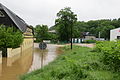
Flood 2013 at the Hirschmühle in Greiz-Aubachtal

Flood in 2013 in the Werlänge road in Greiz-Aubachtal
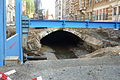
Construction work on the Gräßlitz development in August-Bebel-Straße

Muzzle into the White Elster

Today's Puschkinplatz in Greiz before 1903. The Gräßlitz flows to the left between the railing and the wall.


additional
From Gottesgrün to Greiz-Aubachtal, the Neumark – Greiz railway ran along the left slope of the valley.
Web links
- Greiz Gründerzeit - Open Gräßlitz Historical photos of the open Gräßlitz
Individual evidence
- ↑ a b c d e f g h measured with Google Earth
- ↑ Volkmar Schneider: Greizer home calendar 2004 . Printing & Bookbinding Ernst Tischendorf, Greiz 2003, Greizer Bilderbogen: Elster side valleys, their bridges and special features, p. 36 f .
- ↑ Volkmar Schneider: Greizer home calendar 2011 . Printing & Bookbinding Ernst Tischendorf, Greiz 2010, The overbuilding of the Gräßlitz, p. 21 .
- ↑ a b c d Gerd Elmar König: Greizer Encounters . tape 2 . Buchverlag König, Greiz 2009, ISBN 978-3-939856-24-5 , Chapter 9: Panoramic views - A little journey through time through Mohlsdorf, p. 388 ff .
- ^ Diethard Fricke: The Vogtland around Greiz . TITV eV, Regional Management of the Greiz Region, Greiz 2013, Hike 1: From the Lower to the Upper Castle - through the city center of Greiz, p. 17th f .
- ↑ Volkmar Schneider: Greizer home calendar 2015 . Printing & Bookbinding Ernst Tischendorf, Greiz 2014, From weaver to vocational school teacher, p. 182 .
- ↑ Volkmar Schneider: Greizer Heimatkalender 1999 . Printing & Bookbinding Ernst Tischendorf, Greiz 1998, The Gräßlitz flood of 1889, p. 63 ff .
- ↑ Volkmar Schneider: Greizer home calendar 2013 . Printing & Bookbinding Ernst Tischendorf, Greiz 2012, Greizer Bilderbogen: Raasdorf - Kleinod im Greizer Land, p. 33 .