Kahmer
|
Kahmer
Rural community of Mohlsdorf-Teichwolframsdorf
Coordinates: 50 ° 39 ′ 21 ″ N , 12 ° 17 ′ 8 ″ E
|
|
|---|---|
| Height : | 427 m above sea level NN |
| Residents : | 230 |
| Incorporation : | March 8, 1994 |
| Incorporated into: | Mohlsdorf |
| Postal code : | 07987 |
| Area code : | 03661 |
|
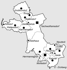
Location of Kahmer in the rural community of Mohlsdorf-Teichwolframsdorf
|
|
|
View of the place
|
|
Kahmer is a district of the rural community Mohlsdorf-Teichwolframsdorf in the district of Greiz in Thuringia .
location
The western exit of the village is touched by the county road 205. A local road leads through the street village to Gottesgrün . There is a larger forest area to the southwest. The other areas are used for agriculture. The local fire brigade is stationed in the center of the village.
history
The district, populated with 230 inhabitants, was first mentioned in a document on May 30, 1261.
Web links
Commons : Kahmer - collection of images, videos and audio files
Individual evidence
- ^ Wolfgang Kahl : First mention of Thuringian towns and villages. A manual. Rockstuhl Verlag, Bad Langensalza, 2010, ISBN 978-3-86777-202-0 , p. 136

