Großkundorf
|
Großkundorf
Rural community of Mohlsdorf-Teichwolframsdorf
Coordinates: 50 ° 44 ′ 36 ″ N , 12 ° 12 ′ 0 ″ E
|
|
|---|---|
| Height : | 360 (323–378) m above sea level NN |
| Residents : | 171 |
| Incorporation : | March 25, 1994 |
| Incorporated into: | Teichwolframsdorf |
| Postal code : | 07987 |
| Area code : | 036624 |
|
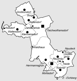
Location of Großkundorf in the rural community of Mohlsdorf-Teichwolframsdorf
|
|
|
View of Großkundorf
|
|
Großkundorf is a district of the rural community Mohlsdorf-Teichwolframsdorf in the district of Greiz in Thuringia .
location
Großkundorf is a street village on Kreisstraße 525. The village is located northwest of Teichwolframsdorf in the East Thuringian Slate Mountains . The municipality is located with its district on the border between Thuringia and Saxony . To the north and east is the rehabilitation area of the former uranium mining.
history
The place was first mentioned in a document on September 24, 1267. 171 people live in the village. Instead of the previous church, a hall church with a choir tower was built in 1748–50 .
Personalities
- Max Berbig (born November 16, 1856 in Großkundorf; † August 24, 1926 in Gotha ), seminar teacher in Gotha and local history researcher
Web links
Commons : Großkundorf - Collection of images, videos and audio files
Individual evidence
- ^ Wolfgang Kahl : First mention of Thuringian towns and villages. A manual. Rockstuhl Verlag, Bad Langensalza 2010, ISBN 978-3-86777-202-0 , p. 102.
- ^ Community Mohlsdorf-Teichwolframsdorf: Locations: Großkundorf. Retrieved June 3, 2017 .

