
Hallesche Kaliwerke
| Hallesche Kaliwerke Aktiengesellschaft | |||
|---|---|---|---|
| General information about the mine | |||
 |
|||
| other names | Saale potash works , Angersdorf mine | ||
| Mining technology | Chamber construction | ||
| Rare minerals | Tachyhydrite | ||
| Information about the mining company | |||
| Operating company | GTS Grube Teutschenthal Security GmbH & Co. KG | ||
| Employees | 390 (1924) | ||
| Start of operation | 1908 | ||
| Successor use | Backfill mine | ||
| Funded raw materials | |||
| Degradation of | Carnallitite / rock salt | ||
| Carnallitite | |||
| Kalifloz Staßfurt (K2) | |||
| Mightiness | 40 m | ||
| Raw material content | 21% | ||
| Rock salt | |||
| Degradation of | Rock salt | ||
| Staßfurt rock salt (Na2), Leine rock salt (Na3) | |||
| Mightiness | 50 m | ||
| Raw material content | 98% | ||
| Geographical location | |||
| Coordinates | 51 ° 27 '13 " N , 11 ° 52' 52" E | ||
|
|||
| Location | OT Angersdorf | ||
| local community | Teutschenthal | ||
| District ( NUTS3 ) | Saalekreis | ||
| country | State of Saxony-Anhalt | ||
| Country | Germany | ||
| District | Halle's potash district | ||

The Halle Kaliwerke Aktiengesellschaft is a former potash mine between Teutschenthal districts Angersdorf and Zscherben , on the outskirts of Halle . The mine is connected underground with the mine field of the former Saale potash works, which is adjacent to the north . In the latter, only stretches were driven without potash or rock salt being mined . The Saale union was owned by Halleschen Kaliwerke Aktiengesellschaft , but was independent under mining law because of the so-called quotation.
The common but unofficial designation "Schachtanlage or Grubenfeld Angersdorf" is common for both mines; today both operating departments of GTS Grube Teutschenthal Sicherheit GmbH & Co. KG , which is a subsidiary of the Geiger group of companies . Because of the minor excavations in the Saale mine field , this mine is to be dealt with in cooperation with the Halleschen Kaliwerk Aktiengesellschaft .
The shafts of the two mines, the Saale shaft and the Halle shaft , are only 730 m apart as the crow flies .
geology


The Kali flöz Staßfurt was applied to a sweeping km completely distance of about 1.6 unlocked and turned in all parts be extremely regularly deposited at a thickness m up to 40th The depth of the rock salt that is worth building is approx. 50 m.
From a geological point of view, the Angersdorf pit is located on the northeast flank of the Teutschenthaler saddle and on the south wing of the Bennstedt - Nietlebener special trough . The Teutschenthal and Angersdorf mining fields, which are very close to one another, have almost the same geological conditions. In the Angersdorf mine field, including the copper shale exploratory boreholes (UT boreholes Teutschenthal 1 and 2), outcrops from the middle to upper Permian (Eisleben layers to snow salt) exist. In particular, the snow salt was approached in a cross passage driven in the direction of NNW , the end point of which was only approx. 12 m below the Lower Buntsandstein .
History of the company
The Hallesche Kaliwerke Aktiengesellschaft was founded in 1905, traded as Hallesche Salzwerke AG from 1929 , took over the Saale trade union, founded in 1910, and the Chemische Fabrik Kalbe GmbH, and moved its headquarters to Calbe. From then on, this stock corporation was called Hallesche Salzwerke und Chemische Fabrik Kalbe . In 1945 the seat was moved again to Halle. In 1947 the stock corporation was expropriated without the consent of the Soviet Military Administration (SMAD). This was followed by the transfer of the company's assets and thus also the pits near Angersdorf into public ownership . On January 1, 1952 were Halleschen salt works as Halle VEB Salzwerke Angersdorf the potash plant Teutschenthal affiliated.
Since May 12, 1992, the Angersdorf mine and the neighboring Salzmünde and Teutschenthal mine interconnected underground have belonged to the GTS Grube Teutschenthal Sanierungs-GmbH company .
The search and exploration work
In the Höffigkeitsgebiet the "International Drilling Company in Erkelenz " sunk a large number of deep boreholes, of which the boreholes Zscherben I, II, IV and V, Bennstedt II and Holleben II, IV and VI struck salt. The bore Zscherben II, which at 579.06 m depth the rock salt was drilled, was continued and opened a of 712.0 m to 752.5 m ranging Carnallitlager ; Zscherben I drilled carnallite from 909.5 m to 957.0 m, Holleben IV drilled hard salt from 539.0 m to 544.6 m and carnallite from 593.17 m to 594.67 m, Holleben VI drilled carnallite from 593.17 m to 594.67 m. The remaining boreholes were only carried out to the rock salt for the purpose of field awarding. The digested hard salt storage resulted in an average KCl content of 19.66%.
The geological and hydrogeological reservoir conditions

The geological and hydrogeological deposit conditions are essentially the same as described in detail in the article on the Krügershall Teutschenthal potash plant .
According to Götze (in Pelzel et al., 1978), the Angersdorf mine is located on the SSE wing of the Bennstedt-Nietlebener special trough, to which the NE flank of the Teutschenthaler saddle connects in the SE. The dip of the deposit varies between 7 and 9 degrees. The salt level is approx. 1000 m south of the Halle shaft in the area of the Holleben 1, 2 and 3 boreholes. This merges towards the east into an eastward sloping salt slope on which deep-reaching salt leaching took place (the 0T Wörmlitz borehole only encountered the Werra rock salt ). The cause of these leaching phenomena can be seen in the fact that the hanging limbs of the Mesozoic Era lifted out to the east, spread out under tertiary cover in broad strips and thus gave the daywaters a broad catchment area.
On the other hand, the large depth of leaching is related to the facial formation of the Zechstein ; While gray salt clay and main anhydrite are normally present in a westerly direction, there is an increase in carbonate facies (irregular strata of marly carbonates and anhydrites) to the east . The rocks of the carbonate facies were strongly fractured and caused a strong water circulation. After the mighty salt deposits of the upper Zechstein had been leached, collapse formations emerged, which were again compressed into breccia by the overlying layers so that they formed dry rocks. Only in individual cases are these rocks nowadays carriers of brines (e.g. OT-Wörmlitz borehole, OT borehole Pfänizenship ). The statements made for the Teutschenthal mine also apply to the hydrogeological conditions of the overburden .
When sinking the Halle shaft, strong water inflows were recorded from the start. The tributaries came from the Middle and Lower Buntsandstein . The inflows were strongest in the 130–140 m depth section at 20 m 3 / h. There are only sparse records of the water inflow when sinking the Saale shaft. For the depth of 20 m, an inflow of 20 l / min is specified, which increased to 170 l / min with increasing depth. According to the records from the 1950s, the inflows fluctuated between 16 and up to 30 l / min as a result of leaky shaft construction . As a result of the washout of the filling site in the carnallitite, its lining continued in 1949 and 1955. In order to avoid further damage, the water that was sitting was diverted to the lower-lying stretches north of the shaft. In the process, 5–10 m deep, canyon-like washouts and crevices as well as larger underlines of stretches were created.
The tectonic conditions of the deposit are determined by its location in the SE part of the Bennstedt-Nietleben special trough. No major tectonic disturbances were found in the area of the mine or in the vicinity. Only the rock salt and kieserite layers that penetrate the potash deposits or the anhydrite and clay layers that penetrate the rock salt deposits indicate small tectonic movements through folds.
The corporate development of both plants from their foundation up to 1992
Hallesche Kaliwerke Aktiengesellschaft

- founding
The "Hallesche Kaliwerke Aktiengesellschaft" was founded on November 14, 1905 in Cologne. The founders were the Internationale Bohrgesellschaft in Erkelenz , General Director Anton Raky in Erkelenz, Johann Ohligschläger in Aachen , the Rheinische Bank in Essen -Ruhr, Fa. Wulkow and Cornelsen in Hamburg , Gebrüder Röchling in Saarbrücken , Jean Balthazar in Bonn and the Saxon-Thuringian corporation for lignite utilization in Halle / Saale.
The company was entered by the commercial court on February 14, 1906 and, after the company's headquarters were relocated from Cologne to Schlettau, on July 18, 1907.
Eight Prussian normal fields lent by the Oberbergamt Halle with the successful wells Zscherben I and Holleben and the later found well Zscherben II in the communities Schlettau , Beuchlitz, Zscherben , Graunau, Bennstedt and Holleben near Halle / Saale.
- Holdings
The company owned the entire 1000 Kuxe of the Saale union as well as 975 company shares of the chemical factory Kalbe GmbH
- Share capital
It was originally five million marks. Of this, two million marks (= 2000 shares) were reimbursed to the founders of the company for bringing in the potash rights of the company, namely:
- of the International Drilling Company 1194 pieces,
- Johann Ohligschläger 412 pieces,
- the Rheinische Bank 218 pieces as well
- of the Saxon-Thuringian stock corporation for brown coal exploitation 176 pieces.
- Capital increases
By resolution of the General Assembly of October 14, 1918 by issuing nom. 1.4 million marks of new ordinary shares, which were used to exchange for Kuxe of the subsidiary "Union Saale". Further increases are documented from the years 1920, 1921 and 1922.
- Changes in company names and ownership
1929 was renamed the company around and called himself Halle salt Werke Aktiengesellschaft . In 1937, in addition to the “Saale” trade union, it also took over Chemische Fabrik Kalbe GmbH and relocated its headquarters from Schlettau to Calbe. From then on it was called Hallesche Salzwerke and Chemische Fabrik Kalbe . Before the end of the Second World War , in early 1945, the company headquarters were relocated to Halle / Saale. This was followed in 1947 by the expropriation and transfer into public property . On January 1, 1952, the Halleschen Salzwerke were incorporated into the Teutschenthal potash works as VEB Hallesche Salzwerke Angersdorf .
Since May 12, 1992, the Angersdorf mine and the neighboring Salzmünde and Teutschenthal mine interconnected underground have belonged to the GTS Grube Teutschenthal Sanierungs-GmbH company .
"Saale" union
- founding
On June 24, 1910 by taking over the rights of the "Saale" mining company in Schlettau near Halle, founded in 1909 with a capital of 100,000 M, the first representative was O. Scheiding, mine director, Halle / Saale.
- Fair
The "Saale" mine, which was created through consolidation , had an area of 14,488,703 m², and is located in the districts of Schlettau, Passendorf, Zscherben, Lieskau, Dölauer Heide forest district, Granau, Nietleben and Bennstedt. In the site plan of the fair (see image above right) there is a fair named "Louisenhall" in the middle of the fair of the Saale union. This is the legal right of the Consolidated Halleschen Pfänkeit regarding the Alt-Zscherben lignite mine, which the Hallesche Pfänkeit on April 29, 1868 together with the former Royal. Prussian lignite mine at Langenbogen as well as the Royal Saltworks Halle had taken over from the tax authorities .
- Two-way question *
Penetrating with the Halleschen Kaliwerke shaft, which is 730 m away from the Saale shaft.
* Even before the turn of the century, there was a provision in the Clausthal Upper Mining District, according to which there should be two separate mobile exits to above the day for all mining facilities, i.e. a target regulation . Here, in the Upper Mining District of Halle, it was reserved for salt mines to a special regulation of the Upper Mining Office, whether and by what time they were to be provided with a second exit. The result was that most of the potash mines under construction in the Halle district initially only had one shaft. However, when a firedamp explosion occurred at the Frisch-Glück potash mine near Eime in 1902, the Prussian Minister for Trade and Industry urged the upper mining authorities in Halle and Clausthal to generally demand the second exit in potash mining as well. Since the shaft of a neighboring mine could be viewed as a second mobile exit, provided a connection was made underground to the neighboring mine field, the requirement for a second exit was satisfied.
- Shutdown
The funding was discontinued as early as 1912. The funding quota was taken over by the “Hallesche Kaliwerke Aktiengesellschaft”, which was owned by all the Kuxe of the Saale union.
In 1925, the decommissioning declaration was submitted to the potash inspection office until 1953 (the reason and the legal basis for the decommissioning are described here ). In 1925, the potash inspection agency gave the plant a stake of 67% of the average participation of all potash plants. In 1926 it was shut down. The union shaft was henceforth kept operational as a second mobile exit for Hallesche Salzwerke AG.
The construction of the Saale and Halle shafts
.png)

Hall shaft
The Halle shaft was sunk from July 8, 1908 to July 18, 1910 to the final depth of 761.0 m. The shaft disc has a diameter of 5.50 m, the shaft mouth is 102.81 m above sea level. NHN .
The following expansion was introduced:
0.0–3.0 m masonry; 3.0 to 266.0 m German tubbing ; 266.0–743.0 m reinforced concrete; 743.0–759.0 m German segments; 759.0–761.6 m reinforced concrete .
Filling locations are at: 628.2 m rock salt weather bed (626 m level); 645.6 m rock salt extraction level (646 m level); 728.9 m potash weather bed (729 m level) and 739.5 m potash extraction level (740 m level).
Saale shaft
The beginning of devastation was on January 1, 1910. On November 12, 1912, the potash store was approached in the shaft at a depth of 825 m. Filling points were set at 840 m and 849 m. The shaft was finally sunk to a final depth of 860.7 m in 1913. Diameter of the shaft tube 5.50 m; the shaft mouth is 96.17 m above sea level. NHN
The shaft is constructed as follows:
0.0 to 3.7 m German tubbing ; 3.7–8.5 m of masonry; 8.5–32.0 m German segments; 32.0–41.0 m of masonry; 41.0–369.0 m German segments; 369.0–860.7 m of masonry.
Two levels are attached to the shaft : A weather level at 839.7 m (840 m level) and the extraction level at 848.7 m (848 m level).
The mining operation
Removal and installation, dismantling and relocation processes

In the mine fields of the Halle and Saale shafts, first carnallitite from the Staßfurt seam (K2), then rock salt from the linen series (Na3) and finally rock salt from the Staßfurt series (Na2) were mined in this chronological order. The void volume of the construction fields was approx. 2 million m 3 (of which 1 million m 3 each in Staßfurt carnallitite and in Leine rock salt) [according to PELZEL et al., 1978, ff].
The brine caverns in Staßfurt rock salt have a volume of approx. 1 million m 3 and are filled with full brine.
In the mining field of the Saale union, only routes were driven. Carnallitite was only mined here briefly in 1916 after the rock attack in the western section of the Halle shaft.
In March 1913, the breakthrough to the pit field of the Halle shaft took place. In the mine field of the Halleschen Kaliwerke, carnallitite of the Staßfurt potash seam was extracted from the 740 m level in the mining chambers from 8 February 1911 to 1928.
The following mining parameters were essentially used: mining width 10–20 m; Pillar width 5–20 m; Dismantling height 7-10 m.
From 1923, the shaking chute was introduced in the floating mining chambers. Partial offset was introduced into the excavation chambers, which filled approx. 2/3 of the original cavity. After the rock attack in the Westfeld in 1916, the extraction of carnallitite was started from the eastern 740 m level. Potash salt was extracted from the overhead and substation mining near the Halle shaft. In 1928 the driveways began in the Leine rock salt about 100 m above in preparation for rock salt extraction. Carnallitite production was ended in the same year.
From 1928 to 1965, Leine rock salt was mined on the 646 m level. The dismantling method was the usual roof chamber construction without offset. The excavations are arranged in a floating manner with the parameters: excavation width 20 m; Pillar width 20 m; Dismantling height 12–15 m, dismantling length 80–100 m. The rock salt mining field has a total extension of 1500 m in a striking and 120–150 m in a crosscutting direction.
First in the western field: 19 excavations using the roof chamber construction method (dimensions of the excavation chambers: length 80 m; width 20 m; height 13–15 m: pillar thickness 20 m). Then in the east field: with the same chamber dimensions from 1953. From 1956 the length of the excavations was extended to 100 m. Up until this type of rock salt mining was discontinued, 17 mining chambers were built here. The rock salt heap was mined from 1928 until the end of operation through the use of vibrating chutes (see top right photo). From 1963 to 1965, the mining chambers "Streichender West" (approx. 240 m long, 20 m wide and 8 m high; stack volume approx. 29,000 m 3 ) and "Streichender" were drawn from the "Lower Weather Line" in an easterly and westerly direction Dismantling East ”(approx. 120 m long, 20 m wide and 2–8 m high; stack volume approx. 5,000 m 3 ) and the debris removed using a scraper.

In 1965 the rock salt production was stopped and the underground borehole extraction began. The Staßfurt rock salt (up to 300 m thick) was extracted by guided brining in 3 underground boreholes. Probes I and II are located in the connecting section between the Halle and Saale shafts. The starting point of probe III is approx. 150 m southeast of the Halle shaft.
Probe I (starting point at −755.4 m above sea level; borehole depth 188.5 m), put into operation on January 16, 1965, had to be shut down in 1974 due to a leak in the area of the suspended rock salt suspension.
Probe II (starting point at −754.6 m above sea level; borehole depth 194.0 m; commissioning in 1966) has not been operated as a reserve cavern since September 1975. Both probes are located in the connection between the Halle and Saale shafts.
Probe III (starting point at −636.6 m above sea level; borehole depth 225.2 m; commissioning on June 15, 1973) located approx. 150 m south-east of the filling point of the potash bottom of the Halle shaft, was the main production probe from 1975 (the right photo shows this Sinking the probe bore). Probe III was taken out of service on December 7, 1979 after 6 years of operation. From then on, the extraction of brine was carried out using two surface probes. These are located outside of the mine field, were "made up" after the brine production was discontinued in 1993 and have been used for underground gas storage until now.
The extracted saline
The Staßfurt rock salt
The fact that Staßfurt rock salt was mined is only known from oral traditions from older hunters . The extraction locations are uncertain. Possibly z. For example, the removal of salts from the connection between the Halle and Saale shafts has been referred to as "rock salt extraction". Most of the Staßfurt rock salt was extracted by means of borehole extraction. During the brining, mainly the middle and lying parts of the Staßfurt rock salt were recorded because of the floating against the routes. An average NaCl content of 88.53% has been determined for the building pane of probes I and II .
The "Staßfurt" potash deposit
In this regard, reference can be made to the information on the Teutschenthal mine field , as the geological positions of the potash store are the same in both mine buildings. Nothing precise is known about the location of the mines at the level of the potash store (stratigraphic classification of the building pane). However, recovery seems to have been avoided mainly in the area above the 10th Unstrutbank. For it speak u. a. various clay breaks that occurred because the levitation of 1 to 2 m against the deck anhydrite / gray salt clay was too low. Carnallitite was extracted from 1911 to 1928 using chamber construction methods and partial backfilling. The excavation chambers were given a floating and floating arrangement and about 70% of the excavation cavity was offset.
The Leine rock salt
The Leine rock salt of the Angersdorf mine is formed as edge facie salt . The Ronnenberg group (orange base salt, line and band salt) is not developed or deviates from the normal profile of the Leine series. Anhydrite salt, steam and clay flake salt are available, but cannot be clearly demarcated from one another.
From 1928 to 1965, the linseed rock salt was extracted in the Firstenkammerbau without offset just above the carnallite field, west and east of the Halle shaft, at a depth of approx. 650 m. The excavation chambers were raised with a slight ridge arching and floating. The maximum dismantling height is 15 m with pillar widths of 20 m. The thickness of the Leine rock salt is on average 50–53 m, of which 12.5–15.0 m were mined. The excavation floor of the rock salt ridges was approx. 25 m above the main anhydrite. From the chamber ridge to the red salt clay a salt packet of approx. 17 m. This "suspension" is caused by the clayey impurities that increase after the hanging wall, which also cause greater difficulties during mining in the form of clay looseners. The rock salt mines are not staggered.
Embedded rock salt nests that occurred sporadically in the mining horizon and reached sizes of a few cubic meters are characteristic of the Leine rock salt from Angersdorf. They consisted of crystal salt as clear as water with inclusions of lye and gas bubbles.
The factory processing of the extracted salts
Saale mine
Since neither carnallite nor rock salt was mined in the pit field of this mine, no manufacturing processing took place here. In the event of later mining of salts, the idea was to process them in the factories of the Halle potash works. Nevertheless, the union already had a "final caustic concession" for the discharge of manufacturing potash final caustic solutions into the Saale above the city of Halle for 5000 quintals of carnallite processing per day . This permit was transferred to Halleschen Kaliwerke Aktiengesellschaft.
Hall shaft system
On October 1, 1907, the construction of the daytime facilities and the 1350 m long connecting line to Schlettau station began. The permit for the discharge of the final caustic solution from the potassium chlorine factory to be built into the Saale above the city of Halle with daily processing of 5000 dz carnallite was granted by the Merseburg district committee even before the factory was built. When it was built, this plant had a grinding plant with two mill systems, six agitated dissolving vessels, a kieserite extraction and washing plant, two complete large evaporation stations (Sauerbrey system), an auxiliary evaporation and preheating plant, a crystallization room with 217 crystallization boxes with 5702 m 3 capacities, a drying station with two drum dryers and a storage room for at least 60,000 dz of packaged salt products. At the beginning of 1911, the processing of the crude salt began. In 1925/26 a bromine and a chlorine magnesium factory were built. Potash fertilizer salts , chlorine potassium, sulfuric acid potassium magnesia and kieserite were produced .
In the early years, e.g. B. delivered: 1911 22,557 dz K 2 O , 1912 52,653 dz K 2 O, 1913 63,489 dz K 2 O. Sales quotas, especially after the First World War and the subsequent loss of the monopoly of the German potash industry, severely restricted sales. In the archives, for example, the maximum sales of these potash products for 1922 is 82,720 dz K 2 O.
As a result of the development in the potash industry at the beginning of the 1920s, which generally resulted in a concentration of the extraction and processing of potash salts on plants with large production, which increasingly restricted the competitiveness of the smaller potash plants, the company saw itself compelled in 1928 to set up its former principal activity, namely to abandon the potash, and their ratio in the potash syndicate and its investments in the by-product generation and -paragraph including the allocation of quotas of the union "Saale", all of whose mining shares were in their possession, with effect from 1st January 1929 to December 31, 1953 to the "Kaliwerke Salzdetfurth A.-G." 1 .
1 Emerged from the stock corporation for mining and deep drilling in Goslar, founded by PRINCE HENCKEL VON DONNERSMARCK and HÜTTENDIREKTOR OSKAR SCHRADER
In January 1928 the mining of rock salt began; In December of the same year, carnallite production was discontinued.
The day facilities were partially made usable for the construction of a modern salt works. The salt works consisted of 10 boiling pans, two of which were equipped with an automatic discharge device. The brine required for the production of evaporated salt was produced by dissolving mined rock salt over the course of the day. In addition, a dry classifier system and a packaging system for the production of packet salt were built. The salt works had an annual production capacity of 40,000 tons of evaporated salt. The brine required for the saltworks operation was produced in five masonry loosening ponds, in which the rock salt extracted and brought to the surface was loosened.
| year | 1938 | 1945 | 1946 | 1947 | 1948 | 1949 | 1950 | 1951 | 1952 | 1953 | 1954 | 1955 | 1956 | 1957 | 1958 | 1959 | 1960 | 1961 | 1962 | 1963 | 1964 | 1965 | 1966 | 1967 | 1968 | 1969 |
|---|---|---|---|---|---|---|---|---|---|---|---|---|---|---|---|---|---|---|---|---|---|---|---|---|---|---|
| Rock salt promotion | 22306 | 24632 | 35920 | 54570 | 58466 | 53173 | 58850 | 51856 | 55384 | 55894 | 66360 | 63457 | 69007 | 67039 | 68579 | 76460 | 85239 | 79463 | 84289 | 85693 | 76375 | 17205 | - | - | - | |
| Production of vacuum salt | 18930 | 15170 | 15246 | 11562 | 12995 | 11063 | 18763 | 18977 | 15056 | 18893 | 17977 | 17411 | 19324 | 20872 | 20176 | 19382 | 18503 | 17333 | 19153 | 21110 | 20544 | 20891 | 22131 | 23894 | 25004 | 12289 |
The rock salt production was stopped at the end of 1966, the vacuum salt production in July 1969. The technical systems were then converted to the extraction of bishopite (MgCl 2 solid).
The mountain blow of 1916
On January 22, 1916, a rock attack occurred in the carnallite field at a depth of 740 m. The size of the construction site affected was around 30,000 m 2 (approx. 100 m across and 300 m across). Of the 13 affected dismantling - their dimensions were quite different - 10 were marked as staggered. The quarries that were excavated in the southern part of the quarry between 1910 and 1913 were 20 m wide, 9 m high and 100 m long. The width of the piers between two quarries was 15 m. Likewise, the excavation chambers excavated in the NW part in 1913 were 15 m wide, 9 m high and 200 m long. The pillars between two quarries were not strictly geometrical and varied in width between 10 and 20 m. To the north-east of the Bruchfeld , the chambers built between 1914 and 1915 were much smaller. Their width was 9–12 m, the pillars that were left were only 6 and 8 m wide.
As offset most likely factory wet processing residue was used. Backfill leaches have been reported that collected in lower-lying quarries and led to the pillar weakening there. The supporting effect of the offset must be assessed as low.
The free space between the offset and the roof is estimated by various authors to be around 0.4 m. With regard to the quality of the offset, the statements by PFORR (1961) are informative: The structures of the fracture field are largely located in the bearing part rich in tachhydrite. In particular, difficulties were encountered with the manufacturing of carnallitite, which has a strong tendency to form sludge. This high proportion of sludge also had a negative effect on the backfill properties of the factory residue, especially because of the moisture content and the poor drainage possibilities of the alkalis contained in the backfill caused by the sludge.
In an evaluation of the mountain range, a letter dated March 6, 1916, demands from the royal mountain district official :
- Bring in dry offset
- Change of mining method, i.e. smaller mining areas and stronger pillars,
- route pillars must also be 10 m wide,
- Introduce the offset quickly (maximum 15 months after dismantling).
This evidence confirms the assumption that in some of the excavations of the fracture field the backfill had not yet been introduced after 15 months, or that these had not yet been or not completely shifted when the rockfall occurred. In view of the high tachhydrite content of the pillar material and the very narrow width of the piers, their partial or complete decomposition by solutions that are unsaturated with MgCl 2 and adhering to the factory residue cannot be ruled out. The offset was apparently not able to sufficiently compensate for the overloading of the mining piers caused by the extreme undersizing (MINKLEY W .; 2001).
There are consistent reports in several sources of earthquake-like vibrations and a violent blast of air, which counteracted the current of weather and caused the intake shaft to blow out for several minutes. This is to be interpreted as a consequence of a compression of the air in the mines by the convergence jump and the collapsing pillars. There is also a report of a relatively even lowering of the roof by an amount that is given as 10 - 20 cm. With regard to the magnitude of this rockfall, there are no metrologically proven values. An estimate based on the relationships between the release of energy, the size of the fracture field, the jump in convergence that has occurred and the voltage drop in the pier support system provides for the local magnitude M L = 3… 3.5. The majority of the quarries located in the rock field were marked as not being offset. The reason for the rockfall is the static undersizing due to the very slim carnallite pillars and the poor quality, especially the excessive humidity of the manual offset (MINKLEY W .; 2003).
State of the mine in 2012
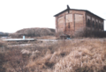
Fig. 1: Covering the Saale shaft in January 2000

Fig. 2: Saale shaft cover on November 2, 2012

Fig. 3: Halle mine on November 2, 2012

Fig. 4: Target borehole for brine cavern III

Fig. 5: Brine elevation, brine cavern III
.png)
.png)

.png)
.png)
Schacht Saale was abgepfropft in 1983-84 above the Salinars, the headframe was dismantled. Above the plug, the shaft has drowned. The shaft opening was covered with a concrete slab (see Figure 1).
The Halle shaft was grafted in 1988. However, the plug was removed again in 1992 for operational reasons (restoration of navigability) (see Figure 2).
The mining company GTS is planning the safekeeping of the Angersdorf mine field including both day shafts. These plans are about to be approved. For the long-term behavior of the stability of the Angersdorf minefield, KNOLL et al. (2000) found that this was mainly due to the three brine-filled caverns in the Staßfurt rock salt (Na2) with a total volume of approx. 1.0 to 1.1 million m 3 (filled with saturated NaCl solution), from the stacked MgCl 2 solutions in the field part at the Saale shaft (approx. 0.1 million m 3 , essentially as "Q solution", i.e. saturated potassium hydroxide solutions, created from undissolved NaCl solutions) as well as air-filled cavities at the level of the rock salt (Na3 ) with a volume of approx. 0.98 million m 3 and at the level of the Staßfurt potash seam with approx. 0.48 million m 3 residual void.
The solutions displaced from Cavern III by the natural convergence have been taken from the cavern as saturated NaCl solutions via a borehole since 1999 and stacked in the Strike Mining West (see Fig. 3 and 4). This keeps them away from potash mining and prevents the effects of dissolution kinetics. Caverns I and II are located near the Saale shaft. Solutions pressed out by convergence reach the potash seam in the area of the connecting surfaces between the Saale and Halle shafts.
"If, according to new geomechanical model calculations that are better adapted to the geometry of the mines, the stability of the protective layers in the weak points is proven, as planned, in particular the rock salt mines and the caverns can be filled and the salt solutions can be bound, the Angersdorf mine field is geological after the shafts are closed Long-term view securely separated from the hydro - and biosphere ”(REICHENBACH, W., 2005).
literature
- W. Blei, W. Jung: About the anomalous Zechstein profiles in the area of the Mansfeld Mulde. (= Freiberg research books. HC 133). Akademie-Verlag, Berlin 1962.
- Werner Gimm , Herbert Pforr: Rock blows in potash mining, taking into account experience in coal and ore mining. (= Freiberg research books. A 173). Akademie-Verlag, Berlin 1961.
- J. Löffler: The potash and rock salt deposits of the Zechstein in the GDR. Part III: Saxony-Anhalt. (= Freiberg research books. C 97 / III). Akademie-Verlag, Berlin 1962.
- Günter Pinzke: "A contribution to the assessment of mining damage of disused potash and rock salt mines". Dissertation. TU Bergakademie, Freiberg 1981.
Web links
- The late Weichselglacial and Holocene climatic and environmental history of the Mansfeld region , dissertation by Volker Wennrich, University of Leipzig (8.4 MB; PDF)
- State of Saxony-Anhalt: Seismology
- State of Saxony-Anhalt: State agency for the clearance of contaminated sites
- Günter Pinzke: Photos of shafts in Saxony-Anhalt and Teutschenthal shaft
- Union and drilling company (2.4 MB; PDF)
- Hans-Heinz Emons: The Potash Industry - History of a German Industry? (1.6 MB)
- Ordinance on the transfer of responsibilities in old mining
- Depiction of mining in Saxony-Anhalt ( Memento from August 12, 2011 in the Internet Archive ) (PDF; 465 kB)
- http://www.hgn-beratung.de/Dateien/Broschueren/TBBr804_Tiebohrtechnik_Kavernenspeicher.pdf
- Early documents and newspaper articles on the Halle potash works in the 20th century press kit of the ZBW - Leibniz Information Center for Economics .
Bibliography
- Florian Weber: Historical Securities - Explanation of Terms
- Hanns Freydank: The Hallesche Pfänerschaft 1500–1926 . Hall 1930.
- Karl Heinz Götz: Collection of mining documents and photos.
- Wolfgang Götze: Exposé, mining part of KALIMAG GmbH . Teutschenthal 1991.
- Dietrich Hoffmann: Eleven decades of German potash mining . Glückauf GmbH, Essen 1972.
- Johannes Kluge: Mining historical documents and photos , private collection.
- P. Knoll, B. Wermuth, M. Finder: Development of a concept for the implementation of security measures for the final safekeeping of the Teutschenthal mine by GTS GmbH & Co. KG, 1st update . Teutschenthal 2006.
- Wolfgang Minkley: Preliminary statement on the possibility of stacking Q-Lye in the deep potash mines ( −667.2 to −638.4 m) of the Angersdorf mine . Ed .: IfG Institute for Mountain Mechanics GmbH. Leipzig 2001.
- Wolfgang Minkley: Mountain mechanical description of softening and brittle fracture phenomena in Carnallitit . TU Bergakademie, Freiberg 2003 (habilitation thesis).
- Julius Mossner (ed.): Handbook of the potash mines, salt pans and deep drilling companies . Finanz-Verlag, Berlin 1936.
- Pelzel, Götze, Bauer, Kiesewetter: Analysis of mining damage in the Teutschenthal and Angersdorf pits . Staßfurt 1978.
- W. Reichenbach: Long-term proof of safety in the Teutschenthal pit, update of the Angersdorf pit, geological section . Ed .: IfG Institute for Mountain Mechanics GmbH. Leipzig 2005.
Individual evidence
- ^ Hallesche Salzwerke and Kalbe AG chemical factory. Retrieved October 12, 2012 .
- ^ GTS Teutschenthal mine. Retrieved October 12, 2012 .
Remarks
- ↑ The direction that runs horizontally across the longitudinal axis of the deposit is referred to as cross-cutting . (Source: Förderverein Rammelsberger Bergbaumuseum Goslar eV (Ed.): Ore mining in Rammelsberg. )