
Angersdorf
|
Angersdorf
Community Teutschenthal
|
|
|---|---|
 |
|
| Height : | 81 m above sea level NHN |
| Area : | 6.37 km² |
| Residents : | 1152 (Apr 29, 2015) |
| Population density : | 181 inhabitants / km² |
| Incorporation : | September 1, 2010 |
| Postal code : | 06179 |
| Area code : | 0345 |
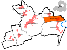  Location of Angersdorf in Teutschenthal
|
|
,_the_village_church.jpg)
Angersdorf is a district of the municipality Teutschenthal in the Saalekreis in Saxony-Anhalt , Germany. The place was co-administered by Teutschenthal until it was incorporated on September 1, 2010.
geography
location
Angersdorf is about 1 km southwest of Halle (Saale) , on a hill west of the Saale floodplain.
To the south of Angersdorf is the Teutschenthal district of Holleben , the district of Zscherben is about 1 km to the northwest.
climate
The annual precipitation is 437 mm. The rainfall is extremely low. They are in the lower twentieth of the values recorded in Germany. Lower values are not registered at any of the German Weather Service's measuring stations . The driest month is February, with the most rainfall in June. In June there is 2.2 times more rainfall than in February. Precipitation hardly varies and is evenly distributed over the year. Lower seasonal fluctuations are recorded at only 24% of the measuring stations .
Local division
Schlettau is designated as a district of Angersdorf.
history
The place name Schlettau is of Slavic origin ( Sletowe ) and dates back to about the year 600, at a time when the Sorbs settled the banks of the Saale. The development of the community took place from then on in close alternation with the city of Halle and the community of Holleben .
Angersdorf and Schlettau belonged to the Hochstift-Merseburg office of Lauchstädt until 1815 , which had been under Electoral Saxon sovereignty since 1561 and belonged to the secondary school principality of Saxony-Merseburg between 1656/57 and 1738 . The Saale formed the border to the Saalkreis, which was under the sovereignty of the Archbishopric of Magdeburg , which came under Brandenburg-Prussian rule in 1680 as the Duchy of Magdeburg . In 1750 the place Schlettau was almost completely destroyed by a devastating fire and had to be rebuilt.
By the resolutions of the Vienna Congress Angersdorf and Schlettau came in 1815 to Prussia and were 1,816 Merseburg in the administrative district of Merseburg of Saxony Province allocated to which they belonged to the 1950s. A new heyday began when the technical age arrived in 1863 with the construction of the Halle-Kassel railway line . The mining of potash and lignite began on a large scale.
The current district of Angersdorf was created in 1936 by merging the towns of Angersdorf and Schlettau. With the first district reform in the GDR, Angersdorf was reclassified from the Merseburg district to the Saalkreis on July 1, 1950 , which came to the Saalkreis in the Halle district during the second district reform in 1952 . With this Angersdorf came to the Saalekreis in 2007. On September 1, 2010 it was incorporated into Teutschenthal. Newly created residential areas have led to a strong influx from the neighboring Halle in recent years.
coat of arms
In the silver coat of arms a red brick round arch stone bridge with (7,4,1) set arches in three levels, which extends to under a narrow head of the shield .
politics
The honorary town mayor Manfred Wagenschein was re-elected in 2015.
Culture and sights
music
- Choir community "Sang und Klang" (since 1901)
Historical monument
- Memorial stone from 1953 on Lauchstädter Strasse for the communist politician Ernst Thälmann , who was murdered in Buchenwald concentration camp in 1944 .
Economy and Infrastructure
economy
The area around Angersdorf is one of the oldest mining areas in the region. In the western part of the village there is a potash mine ("Angersdorf Shaft"), in which potash and rock salt were mined from 1908 to 1993 .
In the north of Angersdorf, directly on the city limits of Halle, a larger industrial area was created in the 1990s.
The chemical sites of Schkopau ( Buna works ; 10 km away) and Leuna (20 km away) are in the immediate vicinity of Angersdorf .
traffic

Angersdorf station is on the Halle – Hann railway line. Münden with local trains stopping every hour in the direction of Halle (Saale) and Lutherstadt Eisleben / Nordhausen .
Angersdorf is connected to the city center of Halle 5 km away via the two-lane federal highway 80 . Via the L164n there is a connection to the Federal Motorway 143, which has been partially completed since 2007, and thus to the double ring of the Central German Loop Halle-Leipzig.
The Leipzig / Halle airport is about 25 km away.
Web links
Individual evidence
- ↑ StBA: Area changes from January 01 to December 31, 2010
- ^ Karlheinz Blaschke , Uwe Ulrich Jäschke : Kursächsischer Ämteratlas , Leipzig 2009, ISBN 978-3-937386-14-0 , p. 84 f.
- ^ The district of Merseburg in the municipal directory 1900
- ↑ Teutschenthal on gov.genealogy.net