Walkstrom
| Walkstrom | ||
|
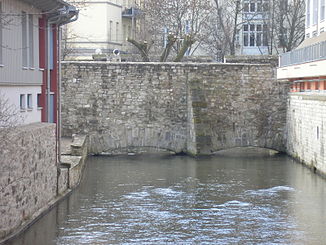
The Walkstrom passes under the inner wall of the Erfurt city fortifications |
||
| Data | ||
| location | Erfurt , Thuringia , Germany | |
| River system | Elbe | |
| Drain over | Gera → Unstrut → Saale → Elbe → North Sea | |
| origin |
Gera between Cyriak- Espachstraße and 50 ° 58 '23 " N , 11 ° 1' 16" O |
|
| confluence | with the mountain stream back to the Gera Coordinates: 50 ° 58 ′ 3 ″ N , 11 ° 1 ′ 16 ″ E 50 ° 58 ′ 3 ″ N , 11 ° 1 ′ 16 ″ E
|
|
The Walkstrom is an arm of the Gera in the western urban area of Erfurt . The Walkstrom got its name from a well-located there Walkmühle , this type of mill was used for cloth finishing or in the tanning of leather. The Walkstrom was part of a water distribution system that had already emerged in the High Middle Ages.
Plans and descriptions of the numerous hydraulic structures are available in the Erfurt City Archives; they allow a meter-accurate reconstruction of the original sections of the former mill and water ditches, which are barely visible in today's cityscape. The Walkstrom flows parallel to the Espachstraße – Gustav-Adolf-Straße – Melanchthonstraße – Fischersand road.
The Walkstrom branches in the southwest of Erfurt between Cyriak- and Espachstraße from the Gera, regulating the water flow was used there, the Espachwehr with the Espachteich . His preliminary destination is the Long Bridge , behind which it reunites with the Gera and from now on flows as a broad stream through the center of Erfurt's old town.
The mill ditch to the Karthäusermühle - also called Karthäusermühle - leads the water to the water-filled moat of the city fortifications, section Kleiner Königsgraben . Its barred passage was inserted into the city wall at the half-moon lock (name probably after the shape). If necessary, fresh water could be fed into the fortress moat here. The Carthusian mill followed right behind the city wall. This was followed by a first connecting ditch to the Gera - the Hanegraben - to supply this craftsmen's quarter with service water. After about fifty meters, the Mühlgraben divided into the western ditch - Walkstrom and the eastern ditch - Hirschlache . The fulling current now met the Neuwerksmühle and at a distance of a few hundred meters on the fulling mill that gave it its name . Again the Walkstrom hit a weir, it withdrew water for the dig , which the Geringsmühle made possible, and flowed into the Gera at the Vogelsbrücke .
The Roßwehr was also on the Gera. Here the Walkstrom flowed into the Wilde Gera . But its water was the by lowering a lock in the branching here to the north Mühlgraben Breitstrom be redirected. As early as 1898, the Wilde Gera was backfilled from Lutherstrasse.
Merian representation
The view of the city of Erfurt contained in the copperplate engraving collection by Matthäus Merian provides an insight into the service water supply and the location of mills and fortification ditches in the city of Erfurt around 1650.
Here mean: (1) Gera, (2) Bergstrom, (3) Karthäuserfluss, (4) Gera, (5) Hahnegraben, (6) Hirschlache, (7) Walkstrom , (8) Wilde Gera, (9) Mühlgraben / width Gera.

