Fougerolles (Haute-Saône)
| Fougerolles | ||
|---|---|---|

|
|
|
| local community | Fougerolles-Saint-Valbert | |
| region | Bourgogne-Franche-Comté | |
| Department | Haute-Saône | |
| Arrondissement | Lure | |
| Coordinates | 47 ° 53 ' N , 6 ° 24' E | |
| Post Code | 70220 | |
| Former INSEE code | 70245 | |
| Incorporation | 1st January 2019 | |
| status | Commune déléguée | |
 Mairie Fougerolles |
||
Fougerolles is a commune Déléguée in the town of Fougerolles-Saint-Valbert with 3,566 inhabitants (at January 1, 2017) in the French department of Haute-Saône in the region Bourgogne Franche-Comté .
geography
Fougerolles is located at an altitude of 305 m above sea level, eight kilometers north of Luxeuil-les-Bains and about 35 kilometers north-northeast of the city of Vesoul (as the crow flies). The village extends in the northern part of the department, on the eastern edge of the plain of Saint-Loup-sur-Semouse, in the valley on both sides of the Combeauté , on the edge of the western foothills of the Vosges .
The area of the 51.12 km² area of the Commune déléguée (and thus the second largest municipal area of the Haute-Saône department until its dissolution in 2019) comprises a section of the valley-traversed plateau landscape on the western edge of the Vosges. From east to west the area is crossed by the alluvial lowland of the Combeauté, which provides drainage via the Sémouse to the Lanterne . The lowland lies at an average of 300 m and has a width of about one kilometer. At Fougerolles, the Combeauté emerges from the plateaus of the western Vosges into the alluvial plain of Saint-Loup-sur-Semouse. On the parish grounds, it includes the Ruisseau des Novelots and the Ruisseau du Bas de la Goutte from the south, and the Ruisseau des Gouttes and the Ruisseau des Pochattes from the north .
South of the Combeauté valley level, the terrain gradually rises to the mostly wooded heights of La Chaîne Roblin (460 m), Croslières and Bois du Fays . The southern border marks the valley of the Rôge , which rises in the Bois du Fays. At 569 m, Fougerolles' highest point is reached in the clearing Le Houssot in the far east .
To the north of Fougerolles, there is an agricultural plateau (around 330 m). An approximately 100 m high step leads to the plateau of the Bois de Lancerand and the Beaumont . The slopes are subdivided by the erosion valleys of various short side streams of the Combeauté. This high plateau reaches a height of 515 m. In the north, it drops abruptly to the deeply cut valley of the Augronne , which marks the northern border of the municipality.
From a geological and tectonic point of view, the heights consist mainly of red sandstone from the Lower Triassic . In some places the crystalline bedrock is also exposed. The valleys are filled with Tertiary and Pleistocene sediments .
In addition to the actual town, the Commune déléguée Fougerolles includes numerous settlements, hamlets and farms, including:
- Les Chavannes (288 m) in the Combeauté valley on the edge of the Saint-Loup-sur-Semouse plain
- La Germenain (321 m) on the plateau south of the Combeauté
- Les Granges de l'Église (352 m) at the height south of the Combeauté
- La Chiquerie (358 m) in the valley of the Ruisseau du Bas des Gouttes south of the Combeauté
- Blanzey (359 m) at the height south of the Combeauté
- Fougerolles-le-Château (313 m) on both sides of the Combeauté
- Croslières (434 m) at the height south of the Combeauté
- Le Champ (335 m) on the northern edge of the Combeauté valley
- Pré du Rupt (325 m) on the plateau north of the Combeauté
- Le Petit Fays (342 m) on the plateau north of the Combeauté
- La Ramouse (358 m) on the ascent to the plateau north of the Combeauté
- Prémourey (435 m) on the plateau between Combeauté and Augronne
- Beaumont (472 m) on the plateau between Combeauté and Augronne
- Blanc Rouchot (430 m) on the plateau between Combeauté and Augronne
- Le Sarcenot (460 m) on the plateau between Combeauté and Augronne
Neighboring municipalities of Fougerolles were Aillevillers-et-Lyaumont and Plombières-les-Bains in the north, Le Val-d'Ajol and Saint-Bresson in the east, Raddon-et-Chapendu , Froideconche and Saint-Valbert in the south and Fontaine-lès-Luxeuil , Corbenay and La Vaivre to the west.
history
The first clearing of what is now the Commune déléguée Fougerolles was probably carried out by the monks of the Luxeuil monastery . In the 11th century, the Baron von Faucogney had a castle built for one of his three sons in the Combeauté valley. The district of Fougerolles-le-Château later developed from this. The rule of Fougerolles, whose name is mentioned in 1131, was always on the borderline of the influence of the Dukes of Lorraine and Franche-Comté. For three centuries it had the status of “Surséance”, which brought certain privileges and freedoms, but also numerous conflict situations with it. Fougerolles suffered during the Thirty Years War.
Unlike the rest of Franche-Comté, Fougerolles did not come to France with the Peace of Nijmegen in 1678. In 1683 the residents swore allegiance to the French King Louis XIV . With the Treaty of Besançon , Fougerolles officially came to the French crown in 1704. After the French Revolution, Fougerolles became the capital of a canton of the same name in 1793, which was integrated into the canton of Saint-Loup-sur-Semouse as early as 1801 .
Thanks to the abundant hydropower, Fougerolles developed very early into an industrial and commercial location with mills, iron and forge works, wood processing, tanneries and the textile industry. Fruit growing and the production of kirsch later became very important. With the opening of the railway line from Aillevillers to Le Val-d'Ajol, Fougerolles was connected to the French railway network in the second half of the 19th century.
The municipality of Fougerolles merged with Saint-Valbert to form the Commune nouvelle Fougerolles-Saint-Valbert on January 1st, 2019 . Since then it has had the status of a Commune déléguée.
Attractions
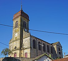
The Saint-Étienne church was built in 1775, later extensively restored several times (the last time in 2001) and is now classified as a Monument historique . The furnishings include the gilded wooden altar, the richly carved choir stalls and paneling from the 18th century. There are eight chapels and numerous Calvaires throughout the parish , including the Calvaire of Blanzey-Haut (16th century; Monument historique) and a stone wayside cross in Le Champ, which is dated to 1212. The Mairie (Town Hall) is located in a large 19th century building. In Le Petit-Fays there is a farm with a cherry distillery, also designated as a monument historique, to which the Écomusée du Pays de la Cerise is affiliated.
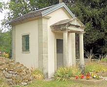
Basse Robert Chapel
Before 1863 there was an old oratory at the site of the chapel along the road from Fougerolles to Le Val-d'Ajol . From 1861 to 1863, the Nurdin and Cholley families from the hamlet of Basse Robert were brought to court over disputes over water rights. Claude Joseph Nurdin swore that if he won the trial, he would build a chapel. In 1862 a judge ordered Joseph Cholley to restore the watercourse to its original state and to pay Claude Joseph Nurdin damages of 2,000 francs. The Nurdin family then built this chapel in 1863 by engraving “Virgin Mary” on the lintel as a token of gratitude. The Basse-Robert chapel remained in the family for a long time. At the beginning of the Second World War it escaped several bombings on the railway line that ran along the banks of the Combeauté . In 2011, the Saint-Étienne de Fougerolles association renovated the exterior and interior of the chapel. Also present was Florent Nurdin , the great great great grandson of the founder Claude Joseph Nurdin . On June 7, 2013, a ceremony was celebrated to mark the chapel's 150th anniversary.
population
With the last 3618 inhabitants (as of January 1, 2016), Fougerolles was one of the largest municipalities in the Haute-Saône department. Fougerolles reached its highest level of population in the period around 1890 with around 6,000 inhabitants. After the population had decreased significantly in the first half of the 20th century, only relatively minor fluctuations were recorded between 1950 and 1990. Since then, a population decrease of around 8% has been observed again.
| Population development | ||||||||
|---|---|---|---|---|---|---|---|---|
| year | 1962 | 1968 | 1975 | 1982 | 1990 | 1999 | 2009 | 2017 |
| Residents | 4185 | 4247 | 4043 | 4155 | 4167 | 3967 | 3839 | 3566 |
Economy and Infrastructure
Fougerolles developed into an industrial and commercial location very early on. The most important employer today is a company that specializes in the manufacture of transmissions for the automotive industry (Lufkin Industries). There are also various small and medium-sized businesses, primarily in the printing and packaging industry, precision mechanics, cherry and schnapps distillery, metal and wood processing, textile industry and in the transport sector. As a regional center, Fougerolles has numerous retail establishments and services for daily needs. It is the location of two colleges. In the last few decades the village has also turned into a residential community. Many workers are therefore commuters who go to work in the other larger towns in the Luxeuil region.
The village is well developed in terms of traffic. It is located near the national road N57 , which leads from Vesoul via Luxeuil-les-Bains to Remiremont . There are other road connections with Saint-Loup-sur-Semouse, Aillevillers, Le Val-d'Ajol and Raddon. The nearest train stations on the Lure-Épinal line are in Aillevillers and Luxeuil-les-Bains.
tourism
Fougerolles has various facilities for tourism. It is the location of the Écomusée du Pays de la Cerise, which is housed in the house of a former owner of a distillery and shows the techniques of making kirsch then and now. In Fougerolles and the surrounding area there are numerous other schnapps distilleries (for cherries, mirabelle plums, plums and pears) that can be visited and inspected. On the border with Saint-Valbert there is an 80 hectare animal park and an arboretum nearby. The municipality of Fougerolles is part of the Ballon des Vosges Regional Nature Park and has numerous hiking and cycling trails for so-called green tourism.


