Urville (Vosges)
| Urville | ||
|---|---|---|
|
|
||
| region | Grand Est | |
| Department | Vosges | |
| Arrondissement | Neufchâteau | |
| Canton | Vittel | |
| Community association | Terre d'Eau | |
| Coordinates | 48 ° 11 ′ N , 5 ° 45 ′ E | |
| height | 327-428 m | |
| surface | 4.02 km 2 | |
| Residents | 57 (January 1, 2017) | |
| Population density | 14 inhabitants / km 2 | |
| Post Code | 88140 | |
| INSEE code | 88482 | |
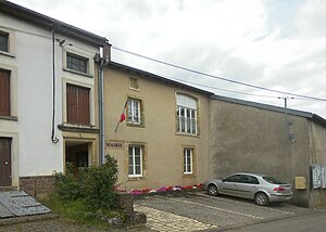
 Mairie Urville |
||
Urville is a French commune with 57 inhabitants (January 1, 2017) in the Vosges department in the Grand Est region ( Lorraine until 2015 ). It is part of the Neufchâteau arrondissement and the Terre d'Eau community association founded in 2017 .
geography
The municipality is located about 20 kilometers west of Vittel in the extreme southwest of Lorraine between the regions of Bassigny in the southwest and Xaintois in the northeast. The western municipal boundary formed the border of the then Lorraine and Champagne-Ardenne regions until 2015 . Several side streams of the Anger , a tributary of the Mouzon , which belongs to the catchment area of the Meuse , have their source in the municipality . The little relief terrain of the 4.02 km² community area is poor in forests; only in the northwest some mountain slopes are covered with forest. Here is the 428 m high La Godelle, the highest point in Urville.
Neighboring municipalities of Urville are Médonville in the north, Aingeville in the northeast, Saint-Ouen-lès-Parey in the east and south, Crainvilliers in the southeast, Vrécourt in the southwest and Soulaucourt-sur-Mouzon in the northwest.
history
During the Ancien Régime , Urville was part of the Bailliage Neufchâteau . In addition, the inhabitants were subjects of the barons of Beaufremont , who shared tithes with the parish of Urville and the canons of Bourmont . Between 1790 and 1800 Urville belonged to the canton of Vrécourt.
Population development
| year | 1962 | 1968 | 1975 | 1982 | 1990 | 1999 | 2006 | 2017 | |
| Residents | 124 | 101 | 86 | 76 | 64 | 64 | 69 | 57 | |
| Sources: Cassini and INSEE | |||||||||
Attractions
- Church of the transfer [of the relics] of St. Martin ( Église de la Translation-de-Saint-Martin ) from the 12th and 13th centuries (tower), with a surrounding wall from the 16th century, Monument historique
- Lavoir
- Fountain
Economy and Infrastructure
There are three farms in Urville (horse and cattle breeding). In addition, services and trade play a certain role.
Urville is away from the nationally important traffic routes. The Autoroute A31 (Dijon-Nancy-Metz-Luxemburg) runs on the southeast edge of the municipality of Urville, but the closest connections to it are ten kilometers away. The D17 leads from Bulgnéville to Vrécourt through the neighboring municipality of Saint-Ouen-lès-Parey , two kilometers away . The nearest railway connection is in Contrexéville, 15 kilometers away, on the railway line from Nancy to Culmont - Chalindrey , which is operated by TER Lorraine .
supporting documents
- ↑ Urville on vosges-archives.com ( Memento of the original from March 5, 2016 in the Internet Archive ) Info: The archive link was inserted automatically and has not yet been checked. Please check the original and archive link according to the instructions and then remove this notice. , PDF file, French, accessed September 2, 2015
- ↑ Urville on cassini.ehess.fr
- ↑ Urville on insee.fr
- ^ Entry in the Base Mérimée of the Ministry of Culture. Retrieved September 2, 2015 (French).
- ↑ Farms on annuaire-mairie.fr (French)

