Lignéville
| Lignéville | ||
|---|---|---|

|
|
|
| region | Grand Est | |
| Department | Vosges | |
| Arrondissement | Neufchâteau | |
| Canton | Vittel | |
| Community association | Vosges Côté Sud Ouest | |
| Coordinates | 48 ° 10 ′ N , 5 ° 57 ′ E | |
| height | 362-457 m | |
| surface | 12.53 km 2 | |
| Residents | 315 (January 1, 2017) | |
| Population density | 25 inhabitants / km 2 | |
| Post Code | 88800 | |
| INSEE code | 88271 | |
 Location of the commune of Lignéville in the Vosges department |
||
Lignéville is a French commune in the department of Vosges in the region Grand Est . It is part of the Neufchâteau arrondissement and the Vosges Côté Sud Ouest community association founded in 2017 .
geography
The community of Lignéville with 315 inhabitants (January 1, 2017) is located four kilometers south of the spa town of Vittel and 45 kilometers west of Épinal in southwest Lorraine.
The 12.5 km² municipal area of Lignéville extends in the area of the Monts Faucilles on the watershed of the catchment areas of the Meuse and Saône . The Ruisseau de Belle Fontaine rises in the municipality and drains over the Petit Vair and the Vair to the upper Meuse. Only about 40 hectares of the municipal area are forested, the majority of the area is used for agriculture.
Neighboring communities of Lignéville are Vittel in the north, Thuillières in the east, Saint-Baslemont in the south-east, Provenchères-lès-Darney and Viviers-le-Gras in the south, Dombrot-le-Sec in the south-west and Contrexéville in the north-west.
Place name
The name Lignéville is of Latin (Gallo-Roman) origin. It is made up of the prefix lignum ( wood ) and villa ( settlement ). Over the centuries, the place name changed several times. Legisvilla is proven for the year 1030 . Via Lyenivillae (1124), Lygnevilla (1402) and Ligniville (1594), the name developed into Lignéville , which has been in use since the 18th century . The local knighthood of those of Lignéville retained the name Ligniville in some branches .
Population development
| year | 1962 | 1968 | 1975 | 1982 | 1990 | 1999 | 2007 | 2016 | |
| Residents | 253 | 272 | 288 | 310 | 323 | 309 | 295 | 316 | |
| Sources: Cassini and INSEE | |||||||||
Attractions
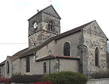
- Saint-Pierre-ès-liens church, classified as a monument historique since 1948
- Saint-Basle chapel with a pietà from the 16th century
- Lavoir
Economy and Infrastructure
There are eight farms in the municipality of Lignéville (dairy farming, horse and cattle breeding).
The main road D 68 leads through Lignéville from Vittel to Saint-Baslemont . There is a connection to the Autoroute A 31 eleven kilometers northwest of Lignéville . The nearest train station is in the neighboring town of Vittel.

