
Valfroicourt
| Valfroicourt | ||
|---|---|---|
|
||
| region | Grand Est | |
| Department | Vosges | |
| Arrondissement | Neufchâteau | |
| Canton | Vittel | |
| Community association | Terre d'Eau | |
| Coordinates | 48 ° 12 ' N , 6 ° 6' E | |
| height | 295-419 m | |
| surface | 13.8 km 2 | |
| Residents | 241 (January 1, 2017) | |
| Population density | 17 inhabitants / km 2 | |
| Post Code | 88270 | |
| INSEE code | 88488 | |

Valfroicourt is a municipality located at 310 meters above sea level in the French department Vosges in the Grand Est region (until 2015 Lorraine ). It belongs to the canton of Vittel in the Neufchâteau arrondissement . It borders in the northwest on Remoncourt , north to Rozerotte , on the northeast by Rancourt , on the east by Bainville-aux-Saules , on the southeast by Frénois and Les Vallois , on the south by Sans-Vallois and southwest of Dommartin-lès-Vallois and Esley .
Population development
| year | 1962 | 1968 | 1975 | 1982 | 1990 | 1999 | 2008 | 2014 |
|---|---|---|---|---|---|---|---|---|
| Residents | 300 | 278 | 236 | 244 | 257 | 258 | 248 | 246 |
Attractions
- Maugiron Castle, built in the 16th century, has been a monument historique since August 31, 1990
- Church of the Assumption ( Église de l'Assomption-de-Notre-Dame )
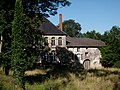
Maugiron Castle

Church of the Assumption

.jpg)
Web links
Commons : Valfroicourt - collection of images, videos and audio files