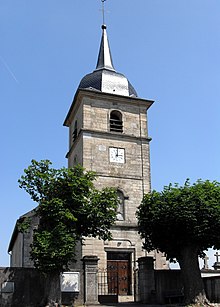
La Neuveville-sous-Châtenois
| La Neuveville-sous-Châtenois | ||
|---|---|---|

|
|
|
| region | Grand Est | |
| Department | Vosges | |
| Arrondissement | Neufchâteau | |
| Canton | Mirecourt | |
| Community association | Ouest Vosgien | |
| Coordinates | 48 ° 18 ' N , 5 ° 53' E | |
| height | 306-363 m | |
| surface | 7.41 km 2 | |
| Residents | 377 (January 1, 2017) | |
| Population density | 51 inhabitants / km 2 | |
| Post Code | 88170 | |
| INSEE code | 88324 | |
 Location of the commune in the Vosges department |
||
La Neuveville-sous-Châtenois is a French commune with 377 inhabitants (January 1, 2017) in the Vosges department in the Grand Est region . It belongs to the Arrondissement Neufchâteau and the municipality association Ouest Vosgien .
geography
The municipality of La Neuveville-sous-Châtenois is located at about 315 m above sea level in the south of Lorraine, about 18 kilometers southeast of Neufchâteau , and about 45 kilometers south of Toul . The village extends in the transition area between the Bassigny as part of the plateau of Langres and the Xaintois . The river valleys, which fan-shaped towards the upper Meuse, are characteristic of the area .
The 7.41 km² municipal area covers a section of the gently undulating landscape in the area of the Maas tributary Vair , whose winding course limits the municipality to the east and north. In the area of the municipality, the small brooks Ruisseau de Niével, Ruisseau de Gerrerupt and Ruisseau du Bougney flow into the Vair from the southwest. The gentle valleys are flanked by partially wooded hills. The municipality includes the forest areas of Le Grand Maix in the north, La Goule in the middle, Le Quartier Notre-Dame in the southwest and Bois du Nouvéchamp in the southeast. The proportion of forests in the municipal area is less than ten percent. By far the largest part of the community area is available for agriculture.
Neighboring municipalities of La Neuveville-sous-Châtenois are Houécourt in the northeast and east, Dombrot-sur-Vair in the southeast, Sandaucourt in the southwest, Longchamp-sous-Châtenois in the west and Châtenois in the northwest.
history
Before the French Revolution, La Neuveville belonged to the Bailiwick of Neufchâteau . The church was part of the deanery Châtenois in the diocese of Toul , the tithe got the chapter Poussay .
A predecessor settlement, which existed in the 10th century and was further to the southwest and thus higher up, was destroyed by Hungarian horsemen . In the period that followed, a new settlement was built directly on the river Vair , which in the middle of the 13th century was large enough to form its own parish and build a first church.
In 1306, Duke Theobald II granted the place called La Nueveville desouz Chastenois the right to hold a covered weekly market. The street name Rue de la Halle has been preserved to this day.
The settlement area was divided into two parts that still exist today: the rue de la Halle as part of the main road from Neufchâteau to Mirecourt formed the economic center of the municipality, while a T-shaped structure developed to the southeast with the Church and the watering hole on Vair stand.
The Church of the Nativity of the Virgin, which had already been closed due to dilapidation, was reconstructed in 1789. After the completion of the work, which fell in the middle of the French Revolution, the church was closed. It was not until 15 years later that the first mass was read in the converted church.
Population development
| year | 1962 | 1968 | 1975 | 1982 | 1990 | 1999 | 2007 | 2017 |
|---|---|---|---|---|---|---|---|---|
| Residents | 303 | 338 | 368 | 373 | 374 | 326 | 360 | 377 |
| Sources: Cassini and INSEE | ||||||||
coat of arms
Blazon : “A silver arched bridge in blue, on it a red shield with the golden initials L and N, above the bridge a golden oak branch, on the upper left the Lorraine coat of arms - in gold a red diagonal bar with three mutilated silver eagles ( Alérion ). "
The bridge stands for the transition over the Vair , the initials for the place name. The Lorraine coat of arms symbolizes the affiliation of the bearer of the coat of arms, the oak leaf symbolizes the vast forests in southwest Lorraine.
Economy and Infrastructure
Agriculture still plays an important role in La Neuveville today. There are three farms in the municipality (mainly cattle breeding). Some residents commute to the nearby industrial parks or the health resorts of Contrexéville and Vittel to the south .
The D 166 trunk road from Épinal to Neufchâteau, which is partially two-lane and free of intersections, bypasses the municipality in the north. It crosses the Autoroute A31 ( Toul - Dijon ) immediately west of La Neuveville . The motorway junction set up here is one of three connections in the Vosges department and an important regional transport hub.
supporting documents
- ↑ La Neuveville-sous-Châtenois on vosges-archives.com. (pdf; 114 kB) (No longer available online.) Archived from the original on December 22, 2015 ; Retrieved June 29, 2011 (French). Info: The archive link was inserted automatically and has not yet been checked. Please check the original and archive link according to the instructions and then remove this notice.
- ↑ Monograph on the history of the place by Abbot Petitjean , pastor in La Neuveville-sous-Châtenois until 1914, published in the parish newsletter
- ↑ La Neuveville-sous-Châtenois on cassini.ehess.fr
- ↑ La Neuveville-sous-Châtenois on insee.fr
- ↑ Coat of arms of the municipality of La Neuveville-sous-Châtenois on genealogie-lorraine.fr. Retrieved July 2, 2011 (French).
- ↑ Farms in annuaire-mairie, fr (French)

