
Poussay
| Poussay | ||
|---|---|---|

|
|
|
| region | Grand Est | |
| Department | Vosges | |
| Arrondissement | Epinal | |
| Canton | Mirecourt | |
| Community association | Mirecourt Dompaire | |
| Coordinates | 48 ° 19 ′ N , 6 ° 7 ′ E | |
| height | 256-327 m | |
| surface | 8.69 km 2 | |
| Residents | 689 (January 1, 2017) | |
| Population density | 79 inhabitants / km 2 | |
| Post Code | 88500 | |
| INSEE code | 88357 | |
 Location of the commune of Poussay in the Vosges department |
||

Poussay (until 1793 still with the spelling Poussey ) is a French commune in the Vosges department in the Grand Est region . It belongs to the Arrondissement Épinal and the municipal association Mirecourt Dompaire .
geography
The community of Poussay, with 689 inhabitants (January 1, 2017), is located 35 kilometers northwest of Épinal and 45 kilometers south of Nancy on the Madon River .
Poussay consists of the old village center, which rises about 20 meters above the lower village, as well as the former manufacturing settlement in the north and spacious single-family house structures in the south, which extend to the limits of the urban area of Mirecourt.
Neighboring communities of Poussay are Ambacourt in the north, Chauffecourt in the northeast, Mazirot in the east, Mirecourt in the south, Ramecourt in the southwest and Puzieux in the northwest.
- Poussay

below the former manufacturing settlement, on the left the lower village, on the slope above the upper village, in the background the area of the agricultural fair

Unterdorf


history
The name of the place is derived from the Latin Portus suaci (or Portus suavis ). The place Poussay was on a road laid out by the Romans.
In the early 11th century, Berthold, Bishop of Toul , founded a Benedictine monastery , the fourth in Lorraine after Remiremont , Bouxières-aux-Dames and Épinal . The abbey was consecrated in 1026.
In 1598, under the aegis of Pierre Fourier, the first girls' school was established in Poussay , where Alix Le Clerc taught free of charge.
The Saint-Maurice church was built in 1757, the town hall ( Mairie ) dates from 1842.
Population development
| year | 1962 | 1968 | 1975 | 1982 | 1990 | 1999 | 2007 | 2017 | |
|---|---|---|---|---|---|---|---|---|---|
| Residents | 457 | 462 | 498 | 786 | 810 | 733 | 725 | 689 | |
| Sources: Cassini and INSEE | |||||||||
Attractions
- Village fountain from the 17th century, when historique monument classified
- Parish Church of St. Mauritius

Village fountain

Southwest side of the church
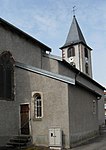
Northwest side of the church
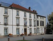
town hall


Economy and Infrastructure
In the south of the municipality is the L'Aéropôle Sud Lorraine industrial park . Not far from the Épinal-Mirecourt regional airport, numerous businesses have been able to settle here, including agricultural and food companies as well as aeronautical engineering companies. Nine farms are located in the municipality (cultivation of grain and nuts, dairy farming, breeding of horses, cattle, sheep and goats).
One of the largest agricultural exhibitions in France with over 1000 exhibitors takes place every year on a site west of the village center.
The D 166 trunk road, which is partially expanded to two lanes, runs through the south of the municipality from Épinal to Neufchâteau with a connection to the A31 autoroute . The railway line from Nancy via Mirecourt and Vittel to Merrey , which is operated by TER Lorraine , runs through Poussay.
Web links
supporting documents
- ↑ toponym on cassini.ehess.fr
- ↑ short summary on foiredepoussay.canalblog.com (French)
- ↑ Poussay on vosges-archives.com ( Memento of the original from March 4, 2016 in the Internet Archive ) Info: The archive link was inserted automatically and has not yet been checked. Please check the original and archive link according to the instructions and then remove this notice. (French; PDF; 50 kB)
- ↑ Poussay on cassini.ehess.fr
- ↑ Poussay on insee.fr
- ↑ Economy on cc-paysdemirecourt.fr ( Memento of May 14, 2013 in the Internet Archive ) (French)
- ↑ Farms on annuaire-mairie.fr (French)