Fomerey
| Fomerey | ||
|---|---|---|
|
|
||
| region | Grand Est | |
| Department | Vosges | |
| Arrondissement | Epinal | |
| Canton | Golbey | |
| Community association | Epinal | |
| Coordinates | 48 ° 13 ' N , 6 ° 20' E | |
| height | 333-381 m | |
| surface | 5.03 km 2 | |
| Residents | 158 (January 1, 2017) | |
| Population density | 31 inhabitants / km 2 | |
| Post Code | 88390 | |
| INSEE code | 88174 | |
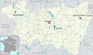
 Location of the municipality of Fomerey in the Vosges department |
||
Fomerey (1801 still with the spelling Fromecy ) is a French commune in the Vosges department in the Grand Est region (until 2015 Lorraine ). It belongs to the Arrondissement Épinal and since 2012 the municipal association Agglomération d'Épinal .
geography
The community of Fomerey with 158 inhabitants (January 1, 2017) is located eleven kilometers northwest of Épinal , the prefecture of the Vosges department.
The Ruisseau de l'Étang , a tributary of the Avière, has its source in the municipality . The Ruisseau de Jaunay, which comes from the northwest, flows northeast of the village center into the Ruisseau de l'Étang . The settlement was built on the slightly elevated terrain between the two streams. The ground relief around Fomerey is characterized by gentle hills, in the east of the municipality the terrain rises gradually and reaches the highest point at 381 meters above sea level.
The town hall ( Mairie ) forms the center of the village, which is surrounded by closed buildings; there is no church in Fomerey. The Route de Gigney to the north is loosely built and merges seamlessly into the area of the municipality of Gigney .
The four forest areas in the west, south-west and east of the municipality have a total area of approx. 100 hectares. Most of the five km² municipal area is used for agriculture.
Neighboring communities of Fomerey are Gigney in the north, Domèvre-sur-Avière in the east, Uxegney in the south-east, Darnieulles in the south and Bocquegney in the west.
history
Remains of a Gallo-Roman settlement were found one kilometer from the village center. The existence of the village of Fomerey has been attested since the 15th century. The spell of Bocquegney , which also includes the village Fomerey mattered was owned by the governors of Darney .
Population development
| year | 1962 | 1968 | 1975 | 1982 | 1990 | 1999 | 2007 | 2017 | |
| Residents | 103 | 112 | 96 | 105 | 112 | 120 | 149 | 158 | |
| Sources: Cassini and INSEE | |||||||||
Attractions
- three wells
- Lavoir
- stone wayside cross
Economy and Infrastructure
Five farms (fruit growing, dairy farming, cattle breeding) and small craft businesses (horticulture, facade renovation, plumbing) are located in Fomerey. Some residents commute to the nearby Épinal agglomeration. Since the school in Fomerey closed, the children have been looked after in neighboring Darnieulles .
Fomerey is connected to the neighboring communities by side roads, south of the community the D 166, which is partially expanded to two lanes, leads from Épinal to Vittel / Neufchâteau .
supporting documents
- ↑ toponym on cassini.ehess.fr
- ↑ Fomerey on cc-olima-aviere.fr ( Memento of January 7, 2015 in the Internet Archive ) (French)
- ↑ vosges-archives.com ( Memento of the original from January 26, 2016 in the Internet Archive ) Info: The archive link was inserted automatically and has not yet been checked. Please check the original and archive link according to the instructions and then remove this notice. (French, PDF file; 91 kB)
- ↑ Fomerey on cassini.ehess.fr
- ↑ Fomerey on insee.fr
- ↑ Farms on annuaire-mairie.fr (French)

