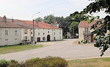
Boulaincourt
| Boulaincourt | ||
|---|---|---|

|
|
|
| region | Grand Est | |
| Department | Vosges | |
| Arrondissement | Epinal | |
| Canton | Mirecourt | |
| Community association | Mirecourt Dompaire | |
| Coordinates | 48 ° 22 ' N , 6 ° 5' E | |
| height | 292-342 m | |
| surface | 2.51 km 2 | |
| Residents | 71 (January 1, 2017) | |
| Population density | 28 inhabitants / km 2 | |
| Post Code | 88500 | |
| INSEE code | 88066 | |
 Location of the commune of Boulaincourt in the Vosges department |
||
Boulaincourt is a French commune in the Vosges department of Region Grand Est (2015 Lorraine ). It belongs to the Arrondissement Épinal and the municipal association Mirecourt Dompaire, founded in 2017 .
geography
The community of Boulaincourt, with 71 inhabitants (January 1, 2017), is located in the Xaintois , 42 kilometers northwest of Épinal and 40 kilometers south of Nancy . The municipality protrudes like a spur to the north into the Meurthe-et-Moselle department .
The Ruisseau de la Grosse Fontaine rises in Boulaincourt and drains south to the Madon tributary of the Moselle . Apart from the settlement area and small, 15 hectares of forest in the north, the municipality consists of arable land and grassland. Immediately north of Boulaincourt, the striking Colline de Sion with the Signal de Vaudémont tower rises 541 meters above sea level.
Boulaincourt's neighboring municipalities are Forcelles-sous-Gugney in the north, Bouzanville in the east, Frenelle-la-Grande in the south and Fraisnes-en-Saintois in the west.
history
In the year 877 a place called Bodelincurte is mentioned for the area . Whether it is Boulaincourt is uncertain.
The choir of the former church was probably built in the 14th century, the mayor's and school building ( mairie-école ) dates from 1867.
Population development
| year | 1962 | 1968 | 1975 | 1982 | 1990 | 1999 | 2007 | 2017 | |
| Residents | 49 | 53 | 50 | 39 | 37 | 37 | 63 | 71 | |
| Sources: Cassini and INSEE | |||||||||
Attractions
From the Assumption Church ( Église de l'Assomption de Notre-Dame ), which was demolished because of the risk of collapse, only two walls remain. The church bells were set into the wall windows. This monument is crowned by the weathercock of the former church.
Economy and Infrastructure
Agriculture continues to play an important role in Boulaincourt and the surrounding area. Four farms are located in the municipality (cereal cultivation, dairy farming).
The village is away from the national traffic flows. The partially two-lane RN 66 runs nine kilometers south of the village and leads from Épinal via Mirecourt to Neufchâteau . The railway line runs through the municipality from Nancy via Mirecourt and Vittel to Merrey , which is operated by TER Lorraine ; the next stop is in Diarville, four kilometers away .
supporting documents
- ↑ | Boulaincourt on vosges-archives.com ( Memento of the original from November 26, 2015 in the Internet Archive ) Info: The archive link was inserted automatically and has not yet been checked. Please check the original and archive link according to the instructions and then remove this notice. (French, accessed on October 28, 2010; no longer available since mid-2016)
- ↑ Boulaincourt on cassini.ehess.fr
- ↑ Boulaincourt on insee.fr
- ↑ Farms on annuaire-mairie.fr (French)


