Laval-sur-Vologne
| Laval-sur-Vologne | ||
|---|---|---|
|
|
||
| region | Grand Est | |
| Department | Vosges | |
| Arrondissement | Epinal | |
| Canton | Bruyères | |
| Community association | Bruyères-Vallons des Vosges | |
| Coordinates | 48 ° 12 ' N , 6 ° 42' E | |
| height | 409-500 m | |
| surface | 3.58 km 2 | |
| Residents | 631 (January 1, 2017) | |
| Population density | 176 inhabitants / km 2 | |
| Post Code | 88600 | |
| INSEE code | 88261 | |
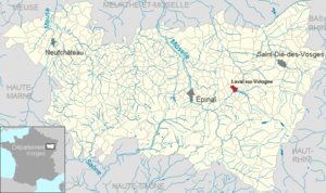
 Location of the commune of Laval-sur-Vologne in the Vosges department |
||
Laval-sur-Vologne is a French commune with 631 inhabitants (as of January 1, 2017) in the Vosges department in the Grand Est region . It belongs to the Arrondissement Épinal and the municipality of Bruyères-Vallons des Vosges .
geography
The municipality of Laval-sur-Vologne is located in the Vosges at an altitude of 420 m above sea level, about halfway between Épinal and Saint-Dié .
The area of the municipal area of 3.58 km² covers a section of the Vologne valley . The Vologne rises on the Vosges ridge, changes its direction of flow by 90 ° from northwest to southwest and thus reaches its northernmost point in Laval. In the municipality, arable and pasture land predominates, only on the slopes of the Haut de Thiémont in the west, south of the Vologne ( Les Noves ) and in the extreme northwest ( Forêt de Faîte ) there are smaller wooded areas.
The traditional paper mill south of the village center, for which water is branched off from the Vologne via the Canal des Usines, is characteristic of the settlement of the village .
The hamlets and farms of Champ Graville, Les Fayés, Les Antilleux and Les Grandes Feignes belong to Laval .
Neighboring municipalities of Laval-sur-Vologne are Bruyères in the northeast, Champ-le-Duc in the east, Fiménil in the southeast, Prey in the southwest and Fays in the west.
history
The village of Laval-sur-Vologne was called Laval until 1937 . In the Ancien Régime it belonged to the bailiwick of Bruyeres and to the parish of Champ-le-Duc, which was dependent on the chapter in Remiremont .
Population development
| year | 1962 | 1968 | 1975 | 1982 | 1990 | 1999 | 2006 | 2017 | |
| Residents | 523 | 548 | 639 | 746 | 687 | 609 | 625 | 631 | |
| Sources: Cassini and INSEE | |||||||||
Attractions
- Church of St. Magdalena ( Église Sainte-Madeleine ), interior renovated in 2009/2010 with money from the sale of the rectory
- Church of St. Magdalena
Economy and Infrastructure
The largest company in Laval is the Novatissue SAS paper mill , a subsidiary of the Italian Cartiere Luccese Spa (Lucart) . The company produces cardboard boxes for food packaging as well as paper towels, toilet paper and handkerchiefs. He is continuing the more than 150-year-old paper processing tradition in the Volognetal . There are also several service companies in the village. There are also seven farms in the municipality (dairy farming, cattle breeding).
Laval is a kindergarten and primary school location.
The road D 44 from Bruyères to Docelles , which follows the Volognetal , runs through the municipality of Laval. The road forms one of the two direct connections between Épinal and Saint-Dié , the two largest cities in the department. The nearest train station is in the small town of Bruyères, two kilometers away, on the Arches – Saint-Dié line operated by TER Lorraine .
supporting documents
- ↑ Monograph de Laval sur Vologne. Archived from the original on July 13, 2012 ; Retrieved October 23, 2011 (French).
- ↑ Laval-sur-Vologne on cassini.ehess.fr
- ↑ Laval-sur-Vologne on insee.fr
- ^ Restoration of the Sainte-Madeleine church. Retrieved October 23, 2011 (French).
- ↑ New production line in the paper mill. (pdf) Archived from the original on May 10, 2012 ; Retrieved October 23, 2011 (French).
- ^ History of Cartiere Luccese with aerial photo of the Laval paper mill. Retrieved October 23, 2011 (Italian).
- ↑ Farms on annuaire-mairie.fr (French)


