
Uxegney
| Uxegney | ||
|---|---|---|

|
|
|
| region | Grand Est | |
| Department | Vosges | |
| Arrondissement | Epinal | |
| Canton | Golbey | |
| Community association | Epinal | |
| Coordinates | 48 ° 12 ′ N , 6 ° 22 ′ E | |
| height | 329-381 m | |
| surface | 8.94 km 2 | |
| Residents | 2,294 (January 1, 2017) | |
| Population density | 257 inhabitants / km 2 | |
| Post Code | 88390 | |
| INSEE code | 88483 | |
| Website | http://www.uxegney.fr/ | |
 Mairie Uxegney |
||

Uxegney is a French commune with 2,294 inhabitants (as of January 1, 2017) in the Vosges department in the Grand Est region (until 2015 Lorraine ). It belongs to the Arrondissement Épinal , the canton Golbey and the municipal association Agglomération d'Épinal . The inhabitants call themselves Ursinia .
geography

The center is located between the Avière and the Canal des Vosges , about six kilometers from Épinal . Neighboring communities of Uxegney are Domèvre-sur-Avière in the north, Golbey in the east, Les Forges in the southeast, Sanchey in the south, Darnieulles in the west and Fomerey in the northwest.
history
In the 10th century Uxegney was mentioned as Ursiniacum and was assigned to the Bailliage of Darney . In the 12th century the village housed two buildings of the Knights Templar . In 1549, the Duke of Lorraine had a water mill built on the Avière. In 1656 the place was mentioned as Uchigney in a document. Uxegney Church is dedicated to Saint Romaric.
Cont
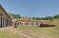
In the area of the municipality are Fort d'Uxegney and Fort de Bois l'Abbé, two of the large fortifications built in a ring around Épinal after the Franco-Prussian War .
- Fort d'Uxegney , (also called Fort Roussel ), located immediately northeast of Uxegney , was built in 1882–1884 and modernized in 1914. On April 29, 2002, it was officially recognized as a Historic Monument .
- The Fort de Bois l'Abbé , including Fort Poniatowski called, is located 370 meters above sea level in a forest 1,500 meters northeast of the village. The fortification was supposed to secure the defense of the road from Épinal to Vittel . Construction of the fort began in 1883 and was continuously expanded and expanded in the years up to 1916. The crew consisted of up to 300 men. Like the neighboring Fort d'Uxegney, the fort belongs to a history association that takes care of maintenance and repair. Guided tours are held twice a year and are attended by several hundred people.


Fort d'Uxegney
Fort de Bois l'Abbé


Population development
| year | 1962 | 1968 | 1975 | 1982 | 1990 | 1999 | 2007 | 2017 |
| Residents | 891 | 1,074 | 1,352 | 1,550 | 1,745 | 1,905 | 2.017 | 2,294 |
Individual evidence
- ↑ Uxegney. In: Base Mérimée. Ministère de la culture, accessed August 9, 2010 (French).
- ↑ Fort de Bois l'Abbé on fortiffsere.fr (French)
Web links
- Images of Fort Uxegney (German)
- Fort d'Uxegney on fortiffsere.fr (French)