Baudricourt
| Baudricourt | ||
|---|---|---|

|
|
|
| region | Grand Est | |
| Department | Vosges | |
| Arrondissement | Epinal | |
| Canton | Mirecourt | |
| Community association | Mirecourt Dompaire | |
| Coordinates | 48 ° 19 ' N , 6 ° 3' E | |
| height | 291-378 m | |
| surface | 3.48 km 2 | |
| Residents | 328 (January 1, 2017) | |
| Population density | 94 inhabitants / km 2 | |
| Post Code | 88500 | |
| INSEE code | 88039 | |
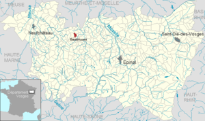
 Location of the commune of Baudricourt in the Vosges department |
||
Baudricourt is a French commune with 328 inhabitants (as of January 1, 2017) in the Vosges department in Grand Est . It belongs to the Arrondissement Épinal and the municipal association Mirecourt Dompaire .
geography
The municipality of Baudricourt is located in the southeast of the Xaintois , about 40 kilometers northwest of Épinal . The landscape around Baudricourt is hilly and characterized by grain fields. With the Bois les Etots , the municipality has around 30 hectares of woodland in the south. The area is drained by the Cochon , a tributary of the Val d'Arol , which flows into the Madon near Mirecourt .
The village is located on the Cochon, nestled between hills in the west and east, the height of which rises above the valley floor by 50 meters. A side valley of the Cochon opens to the north. Baudricourt borders in the northeast on the site of the Épinal-Mirecourt airport , which is operated by the Chamber of Commerce and Industry of the Vosges Department ( Chambre de commerce et d'industrie des Vosges ).
In addition to the core town, the suburb of Bassompierre and the Vorwerk Faubourg Saint-Rémy to the south belong to the municipality. Both districts are on the old road connection from Mirecourt to Neufchâteau .
Neighboring municipalities of Baudricourt are Juvaincourt in the north, Domvallier in the east, Thiraucourt in the southeast, Remicourt in the south, Rouvres-en-Xaintois in the west and Oëlleville in the northwest.
history
The place was first mentioned in the 10th century as Baldricicurt . In the Ancien Régime Baudricourt belonged to the Bailiwick of Mirecourt . The church, consecrated to Saint Remigius , was part of the Poussay deanery within the diocese of Toul . From 1719 to 1766 the village was called Saint-Menge .
coat of arms
The black, red armored and crowned lion on a golden background was originally the coat of arms of the knights and lords of Baudricourt.
Population development
| year | 1962 | 1968 | 1975 | 1982 | 1990 | 1999 | 2007 | 2017 | |
| Residents | 218 | 225 | 172 | 283 | 317 | 280 | 310 | 328 | |
| Sources: Cassini and INSEE | |||||||||
Attractions
- Saint-Remy Church ( St. Remigius )
 |
Economy and Infrastructure
Agriculture still plays a role in Baudricourt (grain and feed cultivation, slaughterhouse). Some residents commute to the business parks at Épinal-Mirecourt Airport or Gironcourt-sur-Vraine .
The partially two-lane expressway D 166 from Épinal via Mirecourt to Neufchâteau bypasses Baudricourt in the south with two connections to the southwest and southeast of the village center. Road connections also exist to the neighboring communities of Offroicourt and Oëlleville .
supporting documents
- ↑ Baudricourt on vosges-archives.com. (pdf; 54 kB) (No longer available online.) Archived from the original on March 5, 2016 ; Retrieved September 3, 2011 (French). Info: The archive link was inserted automatically and has not yet been checked. Please check the original and archive link according to the instructions and then remove this notice.
- ↑ Baudricourt on cassini.ehess.fr
- ↑ Baudricourt on insee.fr


