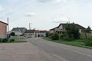
Haillainville
| Haillainville | ||
|---|---|---|

|
|
|
| region | Grand Est | |
| Department | Vosges | |
| Arrondissement | Epinal | |
| Canton | Charms | |
| Community association | Epinal | |
| Coordinates | 48 ° 24 ' N , 6 ° 29' E | |
| height | 293-381 m | |
| surface | 12.26 km 2 | |
| Residents | 167 (January 1, 2017) | |
| Population density | 14 inhabitants / km 2 | |
| Post Code | 88330 | |
| INSEE code | 88228 | |
 Haillainville |
||
Haillainville is a French commune with 167 inhabitants (as of January 1, 2017) in the Vosges department in the Grand Est region (until 2015 Lorraine ). It belongs to the Arrondissement Épinal and the Canton of Charmes .
geography
The municipality is located about 40 kilometers south-east of Nancy on the border with the Meurthe-et-Moselle department . Neighboring communities are Giriviller in the northeast (Département Meurthe-et-Moselle), Clézentaine in the east, Fauconcourt and Saint-Genest in the southeast, Rehaincourt in the south, Damas-aux-Bois in the west and Essey-la-Côte in the northwest (Département Meurthe-et -Moselle).
Population development
| year | 1962 | 1968 | 1975 | 1982 | 1990 | 1999 | 2006 | 2017 |
| Residents | 246 | 226 | 203 | 194 | 193 | 172 | 158 | 167 |
Attractions
- Saint-Èvre church
Web links
Commons : Haillainville - collection of pictures, videos and audio files


