Méménil
| Méménil | ||
|---|---|---|
|
|
||
| region | Grand Est | |
| Department | Vosges | |
| Arrondissement | Epinal | |
| Canton | Bruyères | |
| Community association | Bruyères-Vallons des Vosges | |
| Coordinates | 48 ° 13 ' N , 6 ° 35' E | |
| height | 343-577 m | |
| surface | 9.15 km 2 | |
| Residents | 151 (January 1, 2017) | |
| Population density | 17 inhabitants / km 2 | |
| Post Code | 88600 | |
| INSEE code | 88297 | |
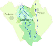
 Location of the municipality of Méménil in the Vosges department |
||
Méménil is a French commune with 151 inhabitants (as of January 1, 2017) in the Vosges department in the Grand Est region (until 2015 Lorraine ). It belongs to the Arrondissement of Épinal and the canton of Bruyères .
geography
The municipality of Méménil is located 15 kilometers northeast of Épinal , the capital ( prefecture ) of the Vosges department.
The municipality of Méménil extends on the edge of a foothill of the Vosges that extends far to the west . Several headwaters of the Durbion ( Ruisseau de la Grande Roye, Le Rouot Ruisseau ) and the Durbion itself - a right tributary of the upper Moselle - have their source in the 9.15 km² municipality . The forest-covered area rises gradually to the south and reaches the highest point on the southern municipal boundary at 577 meters above sea level.
Neighboring municipalities of Méménil are Girecourt-sur-Durbion in the north, Gugnécourt in the northeast (point of contact), Viménil in the east, Fays in the southeast, Deycimont in the south, Le Roulier in the southwest and Fontenay in the west.
history
The name of the village first appeared in writing in 1594 as Memesnil . At that time it was part of the ban of Dompierre in the bailiwick of Bruyères . Ecclesiastically, Méménil belonged to the parish of Aydoilles and only received its own church in 1856. The primary school was built in 1844, and the Mairie building followed in 1882.
Population development
| year | 1962 | 1968 | 1975 | 1982 | 1990 | 1999 | 2007 | 2014 |
| Residents | 136 | 121 | 105 | 92 | 95 | 124 | 153 | 149 |
Attractions
- Church of the Assumption of the Virgin Mary ( Église de l'Assomption-de-Notre-Dame ) from the 19th century
- Church of the Assumption
Economy and Infrastructure
In Méménil there are not only farms but also smaller trading, craft and service companies. Most of the residents commute to the nearby industrial parks in and around Épinal.
The road from Épinal to Saint-Dié-des-Vosges (D 420 or former RN 420 ) passes the neighboring village of Fontenay . Other roads connect Méménil with Girecourt-sur-Durbion, Gugnécourt and Viménil. There is a rail connection at the nearby Épinal transport hub.
supporting documents
- ↑ Méménil on vosges-archives.com. (pdf file; 46 kB) (No longer available online.) Archived from the original on March 4, 2016 ; Retrieved February 5, 2013 (French). Info: The archive link was inserted automatically and has not yet been checked. Please check the original and archive link according to the instructions and then remove this notice.
Web links
- Méménil on comcomadp.fr (French)
- Population development since 1793 (French)


