Dignonville
| Dignonville | ||
|---|---|---|
|
|
||
| region | Grand Est | |
| Department | Vosges | |
| Arrondissement | Epinal | |
| Canton | Epinal-2 | |
| Community association | Epinal | |
| Coordinates | 48 ° 15 ′ N , 6 ° 30 ′ E | |
| height | 322-400 m | |
| surface | 5.93 km 2 | |
| Residents | 190 (January 1, 2017) | |
| Population density | 32 inhabitants / km 2 | |
| Post Code | 88000 | |
| INSEE code | 88133 | |
 Town hall and school building |
||
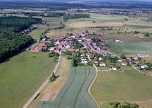
Dignonville is a French commune with 190 inhabitants (as of January 1, 2017) in the Vosges department in the Grand Est region ( Lorraine until 2015 ). It belongs to the arrondissement Épinal , the canton Épinal-2 and the municipal association Agglomération d'Épinal .
geography
The municipality of Dignonville is located about three kilometers northeast of Épinal . Neighboring municipalities are Villoncourt in the northeast, Sercœur in the east, Longchamp in the southeast, Jeuxey in the south, Dogneville in the southwest, Girmont in the west and Bayecourt in the northwest.
history
The place was called Dinovilla in the 11th century, other names were Denovelle (1336), Daigneville (1393) and Degnonville (1494).
Population development
| year | 1962 | 1968 | 1975 | 1982 | 1990 | 1999 | 2006 | 2017 |
| Residents | 123 | 120 | 113 | 174 | 179 | 171 | 188 | 190 |
Attractions
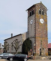
- Church Saint-Vincent in the 16th century
- chapel
- four stone crosses
Web links
Commons : Dignonville - collection of images, videos and audio files


