
Bruyères
| Bruyères | ||
|---|---|---|

|
|
|
| region | Grand Est | |
| Department | Vosges | |
| Arrondissement | Epinal | |
| Canton | Bruyères | |
| Community association | Bruyères-Vallons des Vosges | |
| Coordinates | 48 ° 12 ' N , 6 ° 43' E | |
| height | 390-704 m | |
| surface | 16.02 km 2 | |
| Residents | 3,064 (January 1, 2017) | |
| Population density | 191 inhabitants / km 2 | |
| Post Code | 88600 | |
| INSEE code | 88078 | |
| Website | http://www.ville-bruyeres.fr/ | |
 Bruyères in the Vosges department |
||

Bruyères is a French commune with 3,064 inhabitants (as of January 1, 2017) in the Vosges department in the Grand Est region ( Lorraine until 2015 ). It belongs to the Arrondissement Épinal and is the seat of the community association Bruyères-Vallons des Vosges .
geography
The small town of Bruyères is located in the Vosges at an altitude of 480 m above sea level, about halfway between Épinal and Saint-Dié .

The core of the 16.02 km² community encompasses an area around a mountain saddle , which is framed by four prominent mountain peaks. The center of the village nestles against the southern flank of a 533 m high mountain cone, which is only called a château and on which a castle once stood. A 570 m high hilltop rises to the west, the 571 m high Buemont to the northwest and the Grande Avison with a viewpoint and a radio antenna to the east, reaching 593 m . The saddle on which Bruyères lies forms a watershed . It separates the catchment areas of the rivers Mortagne in the north and Vologne in the south. Several streams arise in the municipality of Bruyères, including the Arentèle , which drains over the Mortagne to the Moselle , the Ruisseau de l'Avison , which flows over the Moxené to the Mortagne and the Lizerne , a small tributary of the Vologne. The highest point in the municipality is marked by a 704 m high sub-peak of Borémont in the far west. The north-western and eastern parts of the municipality are covered by dense forests, which are managed as Forêt Communale de Bruyères . In the lower elevations of the municipality there is arable land, towards the higher forests grasslands and pastures dominate. The settlement image of the small town shows a dense development in the center, which extends from the church and the town hall to the Place Stanislas and also includes some side streets. Several streets with single-family houses have emerged on the periphery. The south of the small town is characterized by a mixture of residential and commercial zones.
Bruyères includes the districts of Le Hallier, Les Baraques, Le Beheue and Haut des Fourches as well as the hamlets and farms L'Écrevisse, La Bouillante, Le Printemps, Grandrupt, Les Sept Sceaux, Grandes Boulayes and La Bergerie .
Neighboring municipalities of Bruyères are Brouvelieures in the north, Vervezelle and Belmont-sur-Buttant in the northeast, La Chapelle-devant-Bruyères and Laveline-devant-Bruyères in the southeast, Champ-le-Duc and Fiménil in the south, Laval-sur-Vologne and Fays in the southwest, Viménil in the west (point of contact) and Grandvillers in the northwest.
history
Settlement and city foundation
The earliest traces of settlement on the terrain of today's city of Bruyeres were found on the summit of the striking Grande Avison mountain . These were stone remains that were interpreted as a shrine and dated to the 3rd or 4th century.
The exposed location at the junction between the Mortagne and Vologne rivers probably allowed military fortifications to be built early on, before a settlement could be spoken of. The mountain, at the foot of which lies Bruyères, has long been known as the Château (= castle) . There are no written records, but it is believed that there was a castle in the 10th century that the Duke of Lorraine built.
The first written records of Bruyères date from the early 12th century and were found in the archives of the Remiremont chapter . A document has survived from 1189 in which Pierre de Brixey , Bishop of Toul, certified a donation from Gérardus de Brueriis to the Beaupré Abbey in what is now the municipality of Moncel-lès-Lunéville . 1196 confirmed Emperor Heinrich VI. in Bruyères passing through the privileges of the bishops of Saint-Dié .
During the 13th century, the village of Bruyères grew along a trade route that led from Arches on the Moselle via Bruyères and Saint-Dié and the Col de Saales into the Alsatian Breuschtal . During the reign of Duchess Katharina von Limburg , who reigned from 1251 to 1255 for her not yet of legal age son, who later became Duke Friedrich III of Upper Lorraine . led, Bruyères got the privileges of a market place . In 1263 the market, together with Arches, was granted city rights .
Late 13th to early 17th century
In the further course of the 13th century there were persistent disputes over the tax revenue of the city between the Chapter Remiremont and the Duke of Lorraine, which were only settled in 1295, when a treaty stipulated the split. This treaty also mentions Audate de Bruyères , the city's first provost . He was appointed by the Duke and entrusted with administrative, tax, police and judicial duties.
The end of the 15th century was also marked by the Burgundian Wars in the western Vosges region. In 1476 the Lorraine duke René II conquered Bruyères, which had been taken a year earlier by the Burgundian duke Charles the Bold .
From the 15th to the 17th centuries, Bruyères experienced a slow but steady upswing due to its geographical location at the intersection of two roads that led to the Vosges crossings (the wine trade played a major role). In 1503 the place had 140 inhabitants, in 1602 545 inhabitants were counted. The parish of Bruyères was founded in 1612, and construction of the church was completed two years later.
From the Thirty Years War to the French Revolution
During the Thirty Years' War the plague claimed many victims (1629/1630), mercenaries of the Protestant princes on the side of Sweden plundered the city twice: in 1635 and 1643. The population fell from 1618 (690 inhabitants) to 330 inhabitants in 1648. How In other parts of Central Europe, too, many areas of land only recovered very slowly - in Bruyères it was not until 1708 that more than 700 inhabitants were counted again.


The 18th century was characterized by economic recovery and relative prosperity. Among other things, more than 200 cattle were sold each year at each of the five markets held. The traders came from Alsace, Lorraine and Burgundy. In 1703 the city built a granary (later used as a school, today as a post office), the courthouse (now the Hôtel de ville ) was built a year later. The Saint-Jean municipal hospital was founded in 1716, and the pharmacy at the hospital also dates from this period, both houses were donated by the Count of Girecourt . At the administrative level, the provost Bruyères became the bailiwick of Bruyères in 1751. In 1779 the city planted linden trees around the new Place Stanislas , which emerged from the old cattle market. The square was named after the Lorraine Duke Stanislaus I. Leszczyński . Bruyères already had 1,813 inhabitants in 1783, including many traders, craftsmen and administrators.
At the time of the French Revolution , Bruyères was initially one of the ten district capitals in the newly created Vosges department . When the then five arrondissements were rebuilt , Bruyères went empty-handed (the area of the former provost's Bruyères was divided into the cantons of Brouvelieures , Corcieux and Bruyères ), so the city became “only” the capital (chef-lieu) of a canton.
19th century
A new economic boom began in the 19th century: on the second and fourth Wednesday of each month, Bruyères held agricultural markets, which were of great importance in the now densely populated Volognetal . The now too small church was demolished in favor of a new, larger one. The new Church of the Assumption of the Virgin Mary was consecrated in 1842. The connection to the railway network created new possibilities. The city made great financial efforts to run the railway line in the Vologne valley in a wide arc up to Bruyères and back into the Vologne valley. The construction of a tunnel and the operation of the station were also at the expense of the city. The Arches - Saint-Dié railway line opened in 1869.
After the end of the Franco-Prussian War in 1871, Bruyères was only 30 kilometers from the German border, which ran on the ridge of the Vosges. Due to its strategic location, Bruyères became a garrison town. Two infantry and one artillery brigade were stationed. The barracks area for several thousand soldiers and officers (quartier Barbazan) was built on the road to Laval in the southwest of the city. The first hotels appeared in the city at the end of the 19th century. The town's residents, who first crossed the 4,000-resident limit in 1891, were also able to work in textile companies in the Vologne valley and in factories that produced potato starch.
20th century
In 1902 the railway line from Bruyères to Rambervillers was opened, so that a continuous connection from Lunéville to Gérardmer was now available.
The First World War from 1914 to 1918 interrupted the development of the city. After the Franco-German border was moved to the Rhine, Bruyères had lost its military importance. The garrison was disbanded and as a result the population decreased from 4,450 in 1911 to 2,908 in 1926.

During the Second World War , the city suffered severe damage. On June 18, 1940, five German planes bombed the city. The German occupation began on June 21, 1940 and lasted until October 1944. During this time, 18 residents disappeared in the Nazi concentration camps, eleven of them Jews. The fighting to liberate the city of Bruyères lasted three days due to difficult topographical and climatic conditions and killed hundreds of soldiers and 25 civilians. On the American side, the 442nd Infantry Regiment and the 100th Infantry Battalion operated with many Hawaiian soldiers of Japanese origin - one reason for the city partnership with Honolulu , which was sealed by veterans in 1961 - against the 736 Grenadier Regiment, the 192 Panzer Grenadier Regiment and the Association of Legion Free India on the side of the Germans.
After 1945
After the war, Bruyères concentrated on building school structures and the health system. A grammar school (lycée) was established in 1965 , followed by a college in 1975 . The city hospital was also modernized and several care facilities were built. In 1960 the production of car rearview mirrors began on the site of a former textile factory near the train station. Due to structural crises and the closure of many medium-sized companies in the 1970s and 1980s, Bruyères also had to struggle with high unemployment; it was followed by a wave of emigration to the industrial companies in the Moselle valley around Épinal. Bruyères today focuses on the health industry and tourism.
Population development
| year | 1962 | 1968 | 1975 | 1982 | 1990 | 1999 | 2007 | 2017 | |
|---|---|---|---|---|---|---|---|---|---|
| Residents | 3639 | 3767 | 3852 | 3679 | 3368 | 3362 | 3310 | 3064 | |
| Sources: Cassini and INSEE | |||||||||
Culture and sights
Churches and chapels
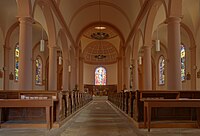
- Church of the Assumption (Église de l'Assomption-de-Notre-Dame)
- Notre-Dame-de-la-Roche chapel on the eastern flank of the Grande Avison
- Church of the Assumption of Bruyères


Former synagogue
In 1903 the Jewish community of Bruyères received a synagogue on the Rue de l'Hôpital . The financial support for the construction came from the Parisian banker Daniel Iffla (1825–1907), who appointed the architect Lucien Hesse to carry out the construction . During the Second World War, the German military profaned the synagogue and used it as a warehouse. From 1942 the Jewish residents of the town were deported and murdered. Since only three Jewish families returned to Bruyères after 1945, the synagogue and the ministre-officiant's house had to be sold. The proceeds were used to rebuild the synagogue in Épinal . In 1994 and 1995 the synagogue was restored. It is classified as a monument historique .
museum
The Henri-Mathieu Museum moved into the building of the old synagogue in 1996 . It shows a collection of ceramics from the 18th and 19th centuries that Henri Mathieu (1913–1994, initiator of the museum) brought together, as well as various objects related to the history of the synagogue and Judaism in the Vosges. Furthermore, pictorial works by Jean Lurçat as well as everyday objects from earlier epochs are shown - including a complete set of old pharmacy equipment.
War memorial
The memorial to the fallen American soldiers was inaugurated in 1947. In 1994 it was expanded by an iron "knot of friendship" that Shinkichi Tajiri created.
Town twinning
Bruyères has partnerships with the small Belgian town of Vielsalm (since 1959) and the Hawaiian city of Honolulu (since 1961). Vielsalm, located between Liège and Luxembourg, has many parallels in history to Bruyères. The partnership with the metropolis Honolulu is unusual because of the size difference (Honolulu has more than a hundred times the population). It results from the fighting of the Allies in October 1944 against the Germans, in which many Hawaiians fought on the side of the Americans. During numerous visits to the theaters of war by former soldiers, the desire for a permanent partnership arose, which was sealed on October 15, 1961 and is now supported by veterans and history associations.
Economy and Infrastructure
The largest employers in Bruyères are the city hospital and various nursing homes. Tourism, trade, crafts and small and medium-sized businesses also offer jobs. In the city center there are around 40 shops and supermarkets, which are also used by the population of the surrounding villages. In addition, many residents are commuters to the nearby industrial zones of the lower Volognetal (paper production) and the Moselle valley . In relation to the number of jobs, agriculture and forestry only play a subordinate role.
education
Bruyères is a kindergarten and school location - also for the nearby small communities:
- École Jean Rostand, kindergarten and preschool
- École Jules Ferry, primary school
- Collège Charlemagne with over 600 students
- Institution Jeanne d'Arc, private school of different age groups
- Lycée Jean Lurçat, state high school since 1979 with over 400 students


Transport links
Several nationally important roads meet in Bruyères. There are favorable connections to Épinal , Remiremont , Rambervillers , Saint-Dié , Anould and Gérardmer . Bruyères station is on the Arches- Saint-Dié line operated by TER Lorraine . The railway line from Bruyères to Rambervillers was shut down in 1980 (passenger traffic) and 1988 (freight traffic).
Personalities
- Jean-Baptiste Mougeot (born September 25, 1776 in Bruyères), French doctor, paleobotanist and botanist
- Antoine Mougeot (born May 8, 1815 in Bruyères), French doctor, paleobotanist and geologist
- Arsène Houssaye (born March 28, 1815 in Bruyères), French journalist, writer and art and literary critic
- Jean Lurçat (born July 1, 1892 in Bruyères), French painter, ceramist and picture maker
- André Lurçat (born August 27, 1894 in Bruyères), French architect
- Gaston Litaize († August 5, 1991 in Bruyères, French composer, organist and music teacher)
supporting documents
- ↑ Drawing of the former castle
- ^ Battle of Bruyères ( Memento from August 15, 2002 in the Internet Archive ) (English)
- ↑ Bruyères autrefois ... - Historical outline by Claude Marchal , Professor of History at the Lycée Jean Lurçat de Bruyères. Retrieved February 19, 2012 (French).
- ↑ Bruyères on cassini.ehess.fr
- ↑ Bruyères on insee.fr
- ↑ Former synagogue, today's Henri-Mathieu Museum in the Base Mérimée of the French Ministry of Culture (French)
- ↑ ville-bruyeres.fr/Tourisme/Musee (French)
Web links
- Community presentation (French)
- Tourism portal Bruyères (French)
- Champ des Roches
- Population statistics