
Fremifontaine
| Fremifontaine | ||
|---|---|---|

|
|
|
| region | Grand Est | |
| Department | Vosges | |
| Arrondissement | Epinal | |
| Canton | Bruyères | |
| Community association | Bruyères-Vallons des Vosges | |
| Coordinates | 48 ° 14 ' N , 6 ° 45' E | |
| height | 329-470 m | |
| surface | 9.56 km 2 | |
| Residents | 469 (January 1, 2017) | |
| Population density | 49 inhabitants / km 2 | |
| Post Code | 88600 | |
| INSEE code | 88184 | |
 Mairie and Elementary School in Fremifontaine |
||

Fremifontaine is a French municipality with 469 inhabitants (1 January 2017) in the department of Vosges in the region Grand Est . It belongs to the Arrondissement Épinal and the municipality of Bruyères-Vallons des Vosges .
geography
The municipality of Fremifontaine is located in the Vosges , 24 kilometers northeast of Épinal and halfway between the towns of Bruyères and Rambervillers .
The 9.56 km² large municipal area includes a section of the western Vosges foothills. The upper reaches of the Mortagne River forms the eastern municipal boundary of Fremifontaines over a length of three kilometers. The mountain streams Xeuty, Corbeuse, Linty and Optinrupt flow into the river valley, which is cut up to 80 meters deep, in the Fremifontaine area . From the left bank of the Mortagne the terrain rises steeply to the west and culminates in a wooded plateau with heights of over 400 m above sea level ( Haut de Xeuty 427 m , Haut de Linty 470 m , Benaté 404 m ). Almost 70% of the community area is covered by forests ( Bois Beni, Bois Chevillots ). In the terrain sloping to the west, the forerunners of today's settlement developed on clearing islands. The upper village ( La Haute Ville ) has now grown together with the middle village ( La Moyenne Ville ) and the lower village ( La Basse Ville ). The western edge of the municipality coincides with the edge of the Vosges and the flatter hill country that begins here and extends to the Moselle, which runs 20 kilometers further west . The west of the municipality of Fremifontaine is drained by the Ruisseau de Dracourt, Ruisseau des Roseaux and Ruisseau de Benazé streams , which flow into Mortagne via the Arentèle .
The neighboring municipalities of Fremifontaine are Sainte-Hélène and Autrey in the north, Mortagne in the east, Domfaing in the southeast, Grandvillers in the south and Pierrepont-sur-l'Arentèle in the west.
history
The area on the western edge of the Vosges was populated as early as Gallo-Roman times . The remains of statues, including those of the goddess Epona , were found near Fremifontaine . The first tradition of the place name Fremifontaine comes from the year 1309, when the Templars were offered a building here. The Templars left the heavily weathered ruins of a castle in the mountain forest southwest of the town center, which are still visible today.
Different families had different rights in the three former districts (Ober-, Mittel- and Niederdorf). The upper village belonged to the sphere of influence of the Abbot of Autrey . Shortly before the French Revolution, the three villages were part of the Bruyères Bailiwick . After the revolution and the foundation of the church, the disputes over the old rights continued for many years. Ecclesiastically, Fremifontaine belonged to the parish of Destord . The Saint-Dié chapter held the patronage rights to this parish . In 1845 the parish church of St. Petri in Ketten ( Église Paroissiale Saint-Pierre-ès-Liens ) was built in Fremifontaine .
Population development
| year | 1962 | 1968 | 1975 | 1982 | 1990 | 1999 | 2009 | 2017 | |
| Residents | 302 | 295 | 296 | 304 | 327 | 347 | 457 | 469 | |
| Sources: Cassini and INSEE | |||||||||
Attractions
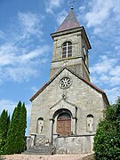
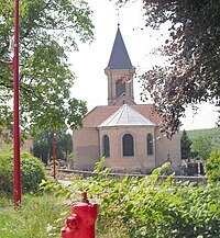
- Parish Church of St. Petri in Ketten ( Église paroissiale Saint-Pierre-ès-Liens )
- Memorial to the 45th US Infantry Division, which played a key role in the liberation of the town in October 1944
- numerous fountains, etc. a. the Fontaine Saint-Firmin from the 12th century
- weathered ruins of a Templar castle on the southern slope of the 470 m above sea level. M. highest point in the municipality
- Church of St. Petri in Chains
_%C3%A9glise.jpg)

Partner municipality
Fremifontaine has a partnership with the American community of Calera in Bryan County, Oklahoma.
Economy and Infrastructure
There are eight farms in the community (potato cultivation, dairy farming, cattle breeding); there is a bakery and a butcher shop. Fremifontaine is also a primary school and kindergarten location.
East and west of Fremifontaine, two roads lead from Rambervillers to Bruyères (D 48 in Arentèletal and D 50 in Mortagnetal). Other roads connect Fremifontaine with Mortagne and Pierrepont-sur-l'Arentèle . The Bruyères station, seven kilometers south of Fremifontaine, is on the Arches- Saint-Dié railway line operated by TER Lorraine . The railway line from Bruyères via Fremifontaine to Rambervillers was shut down in 1980 (passenger traffic) and 1988 (freight traffic).
supporting documents
- ↑ Fremifontaine on vosges-archives.com ( Memento of the original from December 28, 2013 in the Internet Archive ) Info: The archive link has been inserted automatically and has not yet been checked. Please check the original and archive link according to the instructions and then remove this notice. (French; PDF)
- ↑ History abstract on Fremdifontaine.fr ( Memento of December 28, 2013 in the Internet Archive ) (French)
- ↑ Fremifontaine on cassini.ehess.fr
- ↑ Fremifontaine on insee.fr
- ↑ Entry on culture.gouv.fr (French)
- ↑ Farms on annuaire-mairie.fr (French)
Web links
- www.fremifontaine.fr ( Memento of December 28, 2013 on the Internet Archive )
- Population statistics